The CC Trig Point bagger thread, now incorporating other interesting geographs

Page may contain affiliate links. Please see terms for details.

biggs682

Itching to get back on my bike's
Location
Northamptonshire
O e between Denford and Raunds logged before

IMG_20250322_063446_PORTRAIT.jpg
 
Saturday 22nd
1.

Sunday School (originally)
Mill Hill
(off) Wakefield Road
Normanton
Wakefield

IMG_3837.jpeg


IMG_3838.jpeg


To the rear of the Chapel; https://www.geograph.org.uk/photo/7121905
 
Last edited:
Saturday 22nd
2.
The Junction & Midland Hotel (right)
Market Street
Normanton
Wakefield

Both are named such, for the inportant railway junctions that intersected in the town
The Midland seems to have a slightly unsavoury reputation, as it seems to keep closing/licence suspended
The railway station isn't too far away (less than 300yards)
IMG_3839.jpeg


IMG_3841.jpeg


IMG_3842.jpeg


A new sign, as someone's actually realised why it bears that name, for a long time, it just had a 'cross-roads' on the sign
IMG_3840.jpeg


Midland; https://www.geograph.org.uk/photo/3516759
Junction; https://www.geograph.org.uk/photo/363004

Possibly 1920s?; https://maps.nls.uk/geo/explore/#zoom=16.3&lat=53.70175&lon=-1.42466&layers=168&b=ESRIWorld&o=82
 
Last edited:
Saturday 22nd
3.

'Memorial'
Market Place
Normanton
Wakefield
This is a very recent addition, as I have't seen it in the past week or so, plus the local feral youths haven't spray-painted over it

IMG_3843.jpeg


The section of the building to the extreme left was 'Rushworths', the local papershop, where I bought my Cycling Weekly from
Midland Hotel. from *2 is in the background
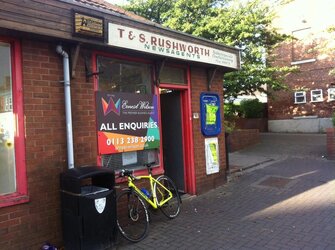
IMG_3851.jpeg

IMG_3844.jpeg

I know of the railways history, but not about the post office
At the time of construction, it was the worlds longest platform, at 1/4 mile long!
IMG_3845.jpeg


IMG_3846.jpeg


IMG_3847.jpeg


IMG_3848.jpeg


1970s?
I remember the buildings being there, but not in use (barring, maybe a couple of store-rooms?\\\\0

14830426480_e2148bab2f_b.jpg


1975, so it states
All of the sidings/goods yard have gone, with houses built there
Every trace of a building is now obliterated (the road bridge is the same, but with the arches filled)
The pedestrian bridge to the 'Station Hotel', later the Flying Scotsman has gone, with just traces of the abutments left (now rebuilt, as 'apartments')
Queen Victoria stayed there once


30645693880_c98f18503d_b.jpg


2009; https://www.geograph.org.uk/photo/3460793
 
Last edited:

PeteXXX

Cake or ice cream? The choice is endless ...
Photo Winner
Location
Hamtun
DSC_5953~2.JPG

Firstly, a BM on the Post Office in St Giles' Street, Northampton.. As it's in an alcove, I think the green algae is of a dubious origin!

DSC_5949.JPG


Beckets Well pic taken from Beckets Park so I didn't get mown down by the traffic!

DSC_5951~3.JPG


DSC_5952~2.JPG

Somewhere @Drago might know well: the Old Police Station in Angel Street.. 👮
 
Wednesday 26th

Trash Screen Bridge
‘Stanley Ferry’
Stanley
Wakefield

The bridge to the left is the 1980s concrete aquaduct carrying the Aire & Calder Navigation Canal over the River Calder
(a grade 1 listed cast-iron aquaduct is out of sight, to the left)

They’re cleaning all of the detritus from earlier high-water
It’s about 12 foot from the mesh to the river, but sometimes it flows over it
(this is a normal level)

IMG_3884.jpeg


I’ve seen it higher than this, seen from the bank where the machinery is; https://www.geograph.org.uk/photo/4740035
 
Last edited:
'Market'?!?
I'm not certain when one solitary stall (selling womens clothes) constitutes a market!!

It made it to the BBC though; https://www.bbc.co.uk/news/articles/cwyj41m3lkvo

There are a few (5?) permanant shops on the periphery (& a 'B&M'); https://www.geograph.org.uk/photo/364091
 
Last edited:
A re-visit, on a dog-walk, this 'village' isn't too far away from where we live
(we did look online, whilst there, at a cottage that's for sale up there - at a surprising price!!)

Saturday 29th
1.

Kings Arms
Heath (conservation village)
Wakefield

IMG_3917.jpeg


IMG_3915.jpeg


IMG_3918.jpeg


https://britishlistedbuildings.co.uk/101135548-kings-arms-warmfield-cum-heath
https://wakefieldvistas.wordpress.com/2019/07/21/heath-village-of-the-mansions/

General view; https://www.geograph.org.uk/photo/2072643
Rear lounge; https://www.geograph.org.uk/photo/7283832
Taken from the demolished (1600's) Heath Old Hall; https://www.geograph.org.uk/photo/7283837
Corridor bar, immediately upon entering; https://www.geograph.org.uk/photo/7283830
 
Last edited:
Last edited:
Top Bottom