The CC Trig Point bagger thread, now incorporating other interesting geographs

Page may contain affiliate links. Please see terms for details.
Sunday 30th
1.

I'd gone back to pick our daughter (& her b/f) up, who'd stayed overnight, at a wedding, at the 'Wentbridge House'

Wesleyan Methodist Chapel
Great North Road
Wentbridge

Now a house

IMG_0629.jpeg


It's around the corner, out of sight, looking southwards; https://www.geograph.org.uk/photo/2642236
 
Last edited:
 
Last edited:
Friday 24th
2.

Marsh Street
Rothwell
(south-east of Leeds, & until the 1600s, of far greater importance than Leeds)

Number 2
View attachment 731884

https://britishlistedbuildings.co.uk/101184702-2-marsh-street-rothwell-ward
https://www.geograph.org.uk/photo/1294306
Monday 1st

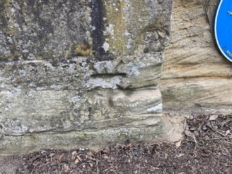
I’d taken my mother shopping to the ALDI (the photograph was taken from their car-park),so just walked over the road to Library to return some books
As l got to the far side, l noticed this stone

IMG_0646.jpeg
 
Tuesday 2nd

The Mexborough (as was)
Church Street
Castleford

We were in there earlier this morning, as Doris (11 month old Border Terrier) was dropped off for speying

IMG_0658.jpeg


The other 2 buildings seen are both pubs
The white one is closed, last open as ’Lagentivm’ (the Roman name of what became Castleford), & prior to that the Horse & Jockey
The tiled building is ’The Junction’
IMG_0659.jpeg


IMG_0657.jpeg


https://www.geograph.org.uk/photo/372666

https://www.geograph.org.uk/photo/372664

EDIT @ 12:29

The fort site was excavated a fair few years ago by ‘Time Team’
It’s just to the north of the ‘Mex’, & is now reburied, for future generations
The Roman crossing point of the River Aire is nearby too, & commemorated by a tile frieze; https://www.geograph.org.uk/photo/393608
 
Last edited:

Badger_Boom

Veteran
Location
York
Tuesday 2nd

The Mexborough (as was)
Church Street
Castleford

We were in there earlier this morning, as Doris (11 month old Border Terrier) was dropped off for speying

View attachment 736150

The other 2 buildings seen are both pubs
The white one is closed, last open as ’Lagentivm’ (the Roman name of what became Castleford)
The tiled building is ’The Junction’
View attachment 736151

View attachment 736149

https://www.geograph.org.uk/photo/372666

https://www.geograph.org.uk/photo/372664

EDIT @ 12:29

The fort site was excavated a fair few years ago by ‘Time Team’
It’s just to the north of the ‘Mex’, & is now reburied, for future generations
The Roman crossing point of the River Aire is nearby too, & commemorated by a tile frieze; https://www.geograph.org.uk/photo/393608

Time Team spent a jolly weekend there, but under various permutations the local authority's archaeologists have been excavating parts of the fort since the 1970s.
 
Tuesday 9th
1.

Miners Welfare Hall
Main Street
Garforth
(east of Leeds)

IMG_0731.jpeg


https://www.geograph.org.uk/photo/2788467
 
Last edited:
Last edited:

Badger_Boom

Veteran
Location
York
Good old Bloody Pomfret. We rented part of the house opposite for a while. It was relatively modern (19th century), but had a stone-built cellar that was originally part of one of the gate houses to the outer bailey.
 
Top Bottom