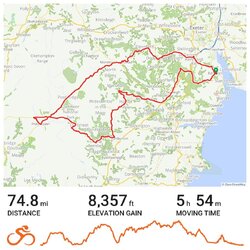
Back in the Belgian Ardennes for my third time, and this is the first day of our stay near Malmedy. We stayed nearby back in 2010, when all of my cycling concentrated on the German-speaking Ost Kantons. This time we are staying to the North of Malmedy, way up above the town in the High Fens Nature Park in a village called Mont at the top of Mont Spinette. Pretty much everywhere I want to cycle will be downhill from here, with an uphill return to figure into my timing calculations. I headed off through the forest along the lumpy, but quite quiet road to Hockai ....
which looked quite flat on Street View, but was actually nearly all either up or down. At Hockai, I hung a right and dropped down onto an old railway line cycle path that is now part of the amazing local "RAVeL" network - old railway paths laid with smooth tarmac, well signposted and with occasional picnic area facilities.


I was well impressed. The first signpost I saw stated that my destination for the morning (Spa) was 11km away, and I knew it would all be downhill. It was quite easy to roll along at over 20mph with little or no pedaling, slowing for dog walkers occasionally, but pleased to see that pedestrians and cyclists seem to co-exist happily here and all dogs are kept on leads. Eventually I arrived in the outskirts of Spa, where I was astonished to have a nonchalant red squirrel casually cross my path. You arrive in Spa via a number of minor road junctions, where all the drivers I encountered slowed right down and seemed to expect me to take priority, thanking me when I did not. The RAVel delivers you right into the heart of town, gradually dropping in altitude all the way. At the very end of it there are plenty of benches and convenient bicycle parking facilities.

I opted to carry on cycling through the streets of the town to take a look at a big church/cathedral that I had spotted on Street View. When I got there, two thirds of it were covered in scaffolding and coloured netting, which was a shame.


I proceeded round to the right, having learned a route that would get me back to the RAVeL, only to find a no entry sign where I really didn't need one to be. And up ahead of me was a long, steep hill, with a railway bridge going over it that I instantly recognised as the one I had just taken a photo from. Nothing for it, I just had to turn back and try to find my way back around the one way system. Easier said than done. Eventually I just got off and pushed for a hundred yards to get back into the road I needed to be in, before climbing back up to the start of the RAVeL for a one hour climb back up to Hockai. Near the top I took advantage of one of the picnic spots which had a view across the valley and the peaceful sounds of bird song and cascading water.

Then it was just the matter of the up and down road through the forest back to Mont. I actually carried on past the house to the old customs house, the "Ancienne Douane" which once marked the border of Germany before the Treaty of Versailles. I know that some Cyclechatters get side-tracked by that Alphabet game, where you have to find places to cycle to in alphabetical order, providing proof of passage. Towns beginning with some letters are hard, if not impossible to find, so some leeway is allowed. I just had to post this picture of the Ancienne Douane taken from just inside "Xhoffraix" though! This part of Belgium is not short of place names beginning with a silent X.
My first 23 miles of the week done. I have a feeling I'll be making much more use of this wonderful RAVel network in the coming week.


