Velo Viewer

Page may contain affiliate links. Please see terms for details.
That's the one I use (every tile) and it's been pretty reliable when Ive flicked it on. My only real criticism is sometimes it's a little too small (big scale) and I'm a little unsure that I am heading towards a red tile or away from it. I am also not sure if the green tiles are those Ive been in on the ride or in the computers memory. But I'd like a record of all time explored cells but I guess that would probably be too memory intensive.
 

Supersuperleeds

Legendary Member
Location
Leicester
That's the one I use (every tile) and it's been pretty reliable when Ive flicked it on. My only real criticism is sometimes it's a little too small (big scale) and I'm a little unsure that I am heading towards a red tile or away from it. I am also not sure if the green tiles are those Ive been in on the ride or in the computers memory. But I'd like a record of all time explored cells but I guess that would probably be too memory intensive.

You can set it to store a grid of 100x100 squares which shows squares you’ve never ridden (red); squares you have ridden (dark green); and squares you have ridden through on the current ride (light green.) It also shows a count of how many unique squares you’ve been through on the current ride along with the number of new squares.

You need to manually update the grid as it doesn’t automatically update after each new ride. I only bother if I’m going to the same area again since the last update.

You also get to choose the centre of the grid, so if going to a new area you can change it.

The links posted earlier should have instructions on how to do it. If not let me know and I’ll post them up.
 

Saluki

World class procrastinator
Although my Veloviewer has lapsed (because I am a twit and didn’t renew, but I will) I never quite understood the tile thing. I could only find it occasionally, by accident. Is it something that I have to be a Strava subscriber to see - the tile thing I mean - as I am not a subscriber to Strava. Totally happy to pay for Veloviewer though. I really liked it.
 

Supersuperleeds

Legendary Member
Location
Leicester
Although my Veloviewer has lapsed (because I am a twit and didn’t renew, but I will) I never quite understood the tile thing. I could only find it occasionally, by accident. Is it something that I have to be a Strava subscriber to see - the tile thing I mean - as I am not a subscriber to Strava. Totally happy to pay for Veloviewer though. I really liked it.

You need a Strava account as Veloviewer pulls your data from there. I don’t know if you need to have a premium account with Strava though.

Personally I do have a premium account as I use their route planner, as I’ve found it the easiest way to plan square grabbing routes.
 

alex_cycles

Veteran
Location
Oxfordshire
You can set it to store a grid of 100x100 squares which shows squares you’ve never ridden (red); squares you have ridden (dark green); and squares you have ridden through on the current ride (light green.) It also shows a count of how many unique squares you’ve been through on the current ride along with the number of new squares.

You need to manually update the grid as it doesn’t automatically update after each new ride. I only bother if I’m going to the same area again since the last update.

You also get to choose the centre of the grid, so if going to a new area you can change it.

The links posted earlier should have instructions on how to do it. If not let me know and I’ll post them up.

Yeah I did all that straight away when setting it up. From now on it should store all the new tiles within that 124x124 grid so shouldn't need updating again unless something goes wrong. It was a bit fiddly getting the map string from computer to phone, but in the end I used Google Keep. (There's no need to use Garmin Express if the Connect IQ app on your phone can use Bluetooth to update settings on your Edge - works fine on the 530.)

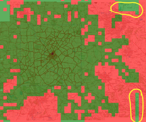
The map string generator doesn't copy ALL your visited tiles (as I assumed it might), just the ones around your max cluster (with 10 squares padding because that's what the KML file from VeloViewer contains). That caught me slightly by surprise when I wondered why the outer edge was more or less square shaped. (Although, revisiting this, some of the outside edge does look wrong, but it's well outside my current area of interest and that looks right, so I'm not bothered at the moment).

Screen Shot 2024-08-03 at 09.33.25.png

Tiles.png Overlaying the output on a map of my VV tiles does show some anomolies, but they are outside my current area of interest.
 
Last edited:

alex_cycles

Veteran
Location
Oxfordshire
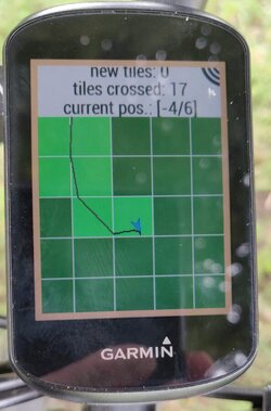
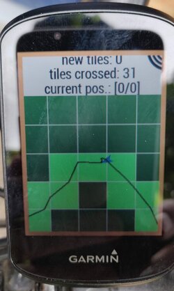
Just tried out the Garmin IQ Everytile app on a ride. It's absolutely brilliant. Shows a trace of your path, a pointer with your heading and all tiles you've visited go bright green. The rest are dark green on my screen because I didn't go anywhere new. But unvisited tiles will be in red I think.
IMG_20240804_114552.jpg about halfway round

IMG_20240804_124842.jpg at the end of the loop.
 
Last edited:

lazybloke

Priest of the cult of Chris Rea
Location
Leafy Surrey
Just tried out the Garmin IQ Everytile app on a ride. It's absolutely brilliant. Shows a trace of your path, a pointer with your heading and all tiles you've visited go bright green. The rest are dark green on my screen because I didn't go anywhere new. But unvisited tiles will be in red I think.
View attachment 739848 about halfway round

View attachment 739849 at the end of the loop.

I was using it on an 87 mile ride last night, it's good, but sometimes i wish it could overlay a simple map, and updating the red/green with each sync would be fab.

I'd planned my route in advance on Strava using the veloviewer plugin, but either I'd screwed up, or some of my roads just missed the squares, so i had to keep getting my phone out and looking at the veloviewer website map to make course corrections. And being a night ride, i was skeep-deprived and made a few bad 'on the fly' routing decisions!
Probably there's something better/quicker on my phone i could use.
 

alex_cycles

Veteran
Location
Oxfordshire
I was using it on an 87 mile ride last night, it's good, but sometimes i wish it could overlay a simple map, and updating the red/green with each sync would be fab.

Oh. Does it not retain the info for new squares you visit?

Perhaps I misread the blurb on the site, or it's written ambiguously? I haven't yet 'flipped' a new tile with it in use.
The list of visited-tiles is persistent. It is reset when the home-coordinates in the settings change. The settings also allow to upload a custom list by providing an encoded string. A string can be generated on http://www.shmo.de/EveryTile

If it's not doing that, it'll need updating regularly, which is a little tedious, but not as tedious as missing squares and having to go back :laugh:
 

Supersuperleeds

Legendary Member
Location
Leicester
Oh. Does it not retain the info for new squares you visit?

Perhaps I misread the blurb on the site, or it's written ambiguously? I haven't yet 'flipped' a new tile with it in use.


If it's not doing that, it'll need updating regularly, which is a little tedious, but not as tedious as missing squares and having to go back :laugh:

No it doesn't retain new squares, you need to re download your KML file, also you need to change your longitude and latitude settings ever time you update. a single digit change is enough on either longitude or latitude.
 
I went and grabbed that tile tonight and the one next to it 🙃

View attachment 739273

View attachment 739274

Increased my max square yesterday afternoon to 26x26. I had set it up for a 27x27 and whilst I could have probably fired google maps up and routed round the closure (its pretty limited area road wise and severed by the A14 though) but I had already done 70 miles in the morning and I'd done 27miles to that point so I turned round and went home so I'd be back before my parents called. It was 59 miles when I got home and 129 miles for the day and I was back with 15minutes to spare.

1722890164827.png


1722889890553.png


My morning ride actually got me a few tiles but it was a group road ride; lol, two of them because the newer gps tracked the road alignment properly (the road down to the Willingham cafe, scone picture below). The other 3 were on the A road north of Needingworth

1722890416279.png
 

Supersuperleeds

Legendary Member
Location
Leicester
21 new squares today which saw me increase the cluster by 26.

I have to ride at least 40 miles now before grabbing a new square, today was nearly 70 miles into the ride before the first one was bagged. I'm now at the point were the only way to really extend everything is by either driving out to a start point or getting a train to a start point and riding back, or vice versa, or move house ^_^

1722891287783.png
 
21 new squares today which saw me increase the cluster by 26.

I have to ride at least 40 miles now before grabbing a new square, today was nearly 70 miles into the ride before the first one was bagged. I'm now at the point were the only way to really extend everything is by either driving out to a start point or getting a train to a start point and riding back, or vice versa, or move house ^_^

View attachment 739983

It gets boring east of Pottyboro (Peterb) anyway :okay:

I live in the town but my max square only goes 6km to the east.

1722892018158.png
 
Top Bottom