The Rail Enthusiast thread

Page may contain affiliate links. Please see terms for details.
Sunday looks like it's going to be a 'family day-out'
I've suggested Pickering & Thornton-le-Dale

With a route there (or back) via Helmsley & Ampleforth

I'll hazard a guess that most of you know one of the reasons for Pickering^_^
Even though it's not open for the season, till 6th April, there's bound to be some activity so close to the date?
(well, and for the 'geographs' thread too!!)
For those that may not, shame on you!!

Pickering; https://www.nymr.co.uk/
Thorton-le-Dale; https://mathewsons.co.uk/ (it's the garage featured in the TV series 'Bangers & Cash')
Ampleforth (or to be more accurate, Gilling East) https://rsme.org.uk/index.php

YES!!, there will be photographs

EDIT @ 11:51
The other directions journey will be via Sutton Bank & Thirsk, which I like as a market town


Sadly there was nothing happening at Pickering Station, just the teak LNER coaches at the platform (out of the worst of the winters weather, I guess?)
Plenty of volunteers about though, & at least a dozen in the same café as us
(always a good sign, when 'locals' use it)


Gilling East was also quiet, with just a trio of guys there, performing a bit of track-repair
We did get invited in, to have a look at the grounds though
I did expect some 'pre-season' running from an engine or two?

508627


I seem to recall that this covers some 'underground' sidings?
508628


508629


508630


508631


This lift is for the bigger guages:eek:

508632


View: https://www.youtube.com/watch?v=W7z8GpmZI30


View: https://www.youtube.com/watch?v=2xu5I6S0Dyk
 
Last edited:
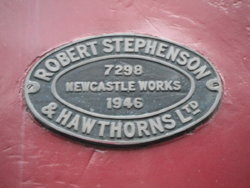
On the way back from photographing 'Black Dicks Temple'. I passed the National Coal Mining Museum, & stopped to photograph an outside exhibit
509028


509029


509027


https://preservedbritishsteamlocomo...rn-works-no-7298-christopher-progress-0-6-0t/
Before it was moved to road-side display; https://www.geograph.org.uk/photo/4645387
 
On the way back from photographing 'Black Dicks Temple'. I passed the National Coal Mining Museum, & stopped to photograph an outside exhibit
View attachment 509028

View attachment 509029

View attachment 509027


https://preservedbritishsteamlocomo...rn-works-no-7298-christopher-progress-0-6-0t/
Before it was moved to road-side display; https://www.geograph.org.uk/photo/4645387

I love the vagueness of that address: "Near Wakefield..."

By way of a contrast in technology, this high-tech piece of kit insinuated its way into Emmendingen station while I was waiting for my train back today:

2020_03_18_Emmendingen_Flat_31.JPG


Normally I'm all for interesting big yellow machines but I was a bit apprehensive about this one as I knew there had been problems (probably a suicide, sadly) earlier in the line to the south, but my train came along on time and as it did, this trundled off towards Freiburg.
 
I love the vagueness of that address: "Near Wakefield..."

Wakefield was still the County town at that point, so in a way it is a bit odd to us
But, there would have been no such thing as postcodes back then

Wakefield, was the centre of a very large area over the centuries
The jurisdiction of its Manorial Courts, for example, extended as far west as Todmorden (from the 1300s till into the 1800s)
 
Last edited:

rogerzilla

Legendary Member
Class 20s look pretty funky in DRS livery. They are truly ancient - they've outlived a lot of people born at the same time! Very simple, though, and there isn't anything else in that (Type 1) power range.
 
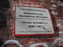
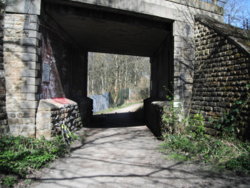
It seems that Northallerton has moved over 40miles:wacko:

Circa 2 miles east of Wakefield city-centre; https://www.geograph.org.uk/photo/3675625

510805 510806


Edit @ 12:22


And it's certainly not NewLands Lane, at that point either
The closest named road that I can see (or know of) is 'Half Moon Lane'
Kirkthorpe (1)
https://www.geograph.org.uk/photo/6093263


It comes out, in the village, near a 1780s House; https://www.geograph.org.uk/photo/2079292
Plus, there's a 1595 'Hospital' - more correctly, an Almshouse; https://www.geograph.org.uk/photo/2388953


1. a 'conservation village'. as is Heath, approximately 1/2 mile to the south-west, but that has a LOT more houses worthy of the term
 
Last edited:
At work yesterday afternoon, one of the other staff told me about a minature railway in the woods that he walks his Dogs in
After a brief search, it turns out to be this
Just over a mile from the 'White Rose Shopping Centre'

http://churwellwoodlandrailway.simplesite.com/423638325

Plus there's this one, a similar distance to the other side of 'W R S C' (just off Bradford Road, between jct 41/M1 & jct 28/M62)
https://sites.google.com/site/westridingsmallloco/home
I've been there a few times, as we knew one of the 'main men', before he passed away
 
This morning
After dropping daughters car off for an MoT test, & whilst waiting for the phone-call to walk back to collect it


Lady Ann Road
(at junction with Primrose Hill)
Batley

Long, dark, sloping, very restricted height (under 6foot points!)

511396


511397


511398


From the west side;
511399


https://britishlistedbuildings.co.u...-mdl131-lady-ann-road-subway-batley-east-ward

https://www.geograph.org.uk/photo/5428637
Only one light working, at the moment; https://www.geograph.org.uk/photo/5428646
https://www.geograph.org.uk/photo/5434006
 
Top Bottom