The CC Trig Point bagger thread, now incorporating other interesting geographs

Page may contain affiliate links. Please see terms for details.
 
Tuesday 1st
1

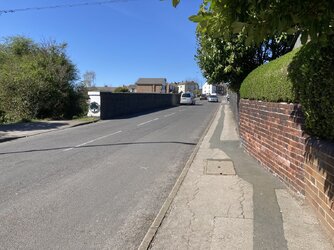
Church Of St Peter Gates
Stanley
Wakefield

As seem from Aberford Road/A642
It wasn't an old Church, being rebuilt just before WW1, but mining subsidence was its (quite literal) downfall
(mining, footwear & rhubarb/market gardening, were 3 of the big local employers

We were taking my mother shopping, so once more I walked part-way with the dog


IMG_3957.jpeg


https://en.m.wikipedia.org/wiki/St_Peter's_Church,_Stanley,_West_Yorkshire

The Church can be seen, it was probably already closed/decommisioned by then; https://www.geograph.org.uk/photo/2935303
 
Last edited:
Tuesday 1st
4.

Church Of St Peter Cemetery
Stanley
Wakefield

Looking northwards, towards Lake Lock Road
The 3 buildings just beyond the hedge (on 'LLR') are associated with the long-established local funeral director, the steep white 'gable-end', being their Chapel of Rest
The Wesleyan Methodist Chapel, on Mount Road, can be seen (large building), it's now in private hands, & being converted into a house/flats
(more photos/information)

IMG_3970.jpeg


This gravestone used to have a carved Anvil on top

IMG_3971.jpeg


The gates, at Lake Lock Road

IMG_3972.jpeg


The gates, with Bells Funeral Director showing, at the junction with Mount Road; https://www.geograph.org.uk/photo/7755958
When the Anvil was still in place; https://www.geograph.org.uk/photo/1001359
 
Last edited:
Tuesday 1st
5

St Peters Infant School
Stanley
Wakefield

It was the School, now home to a playgroup, there's a Sunday Service, & the groups that used the (demolished) Church meet here

IMG_3973.jpeg


Behind it runs one of the local 'wagon-ways', from collieries, to a loading staith on the (previous alignment of (what became) the Aire & Calder Navigation Canal (parts are stll in water, but as simply fishing ponds)
Now a public footpath, to cut a corner from Mount Road, to Aberford Road

https://www.geograph.org.uk/photo/499339
https://www.geograph.org.uk/photo/4321807
 

Attachments

  • IMG_3974.jpeg
    IMG_3974.jpeg
    304.3 KB · Views: 0
Last edited:
There might be a few additions from around the Barnsley area tomorrow, as I have to take the trailer & help friends of ours to empty there 'self-storage' unit
I'll be passing through Barnsley itself, along the A61, to Worsborough
Passing what was a level-crossing, on the old 'Woodhead Line', a canal basin, & what used to be the home of a Planet X shop, plus passing the obelisk at Birdwell
 
Last edited:

Badger_Boom

Veteran
Location
York
Tuesday 1st
4.

Church Of St Peter Cemetery
Stanley
Wakefield

Looking northwards, towards Lake Lock Road
The 3 buildings just beyond the hedge (on 'LLR') are associated with the long-established local funeral director, the steep white 'gable-end', being their Chapel of Rest
The Wesleyan Methodist Chapel, on Mount Road, can be seen (large building), it's now in private hands, & being converted into a house/flats
(more photos/information)

View attachment 767505

This gravestone used to have a carved Anvil on top

View attachment 767506


The gates, at Lake Lock Road

View attachment 767507

The gates, with Bells Funeral Director showing, at the junction with Mount Road; https://www.geograph.org.uk/photo/7755958
When the Anvil was still in place; https://www.geograph.org.uk/photo/1001359

It's been so long since I drove along Aberford Road that the church was still standing then.
 
Top Bottom