Tiny rides of 2023

Page may contain affiliate links. Please see terms for details.
Tiny ride last week:
went out to test ride an old bike i've been refurbishing. got a few hundred meters from the house and the chain broke!
slightly embarrassing walk back to the house with chain in hand.
i'm just glad this was a tiny ride and i wasn't phoning for help (come to think of it i don't even think i had my phone on me)
 

Windle

Über Member
Location
Burnthouses
A belated tiny ride report from Friday gone when I went to see the National Circuit Championship race which was hooning round Darlington town centre. I didn't have time to ride there and back so it was car to the outskirts and ride into town past the Mowden pub, traversing the two (usually very busy) mini roundabouts then along the slightly odd and much talked about Woodlands road cycle path, which I believe took the council two goes to get right. There were a surprisingly large number of visitors there to see the race, and of course it being Friday night it was busy with pub-goers as well. The whole route was barriered off fortunately so everything seemed to work OK. Anyway, a few photos from the evening. Riders amassing on Prebend Row just before rolling up to the start.

GOPR1015.JPG

The bottom part of the circuit with the corner of the old Northern Echo building to the right and one of Darlos 'spoons, The William Stead (former editor of the Northern Echo) opposite, Cornmill shopping centre behind.

GOPR1011.JPG


Blurry action from the roundabout at Crown Street / East Street with the old Post Office building opposite and behind me the empty carcass of the departed Wilko :sad:.
GOPR1017.JPG

I recall years back (probably mid '80's) there being evening crits round the town centre occasionally, running anti-clockwise along High Row, then up Bondgate before turning a tight left along Skinnergate (there was a chemist on the corner that always needed straw bales piled in front to prevent unwanted after hours flying visitors) then left again down Blackwellgate and back to High Row.
A decent night's entertainment although only 5 miles ridden. I even got me 'sell on the telly :tongue:.
 
Last edited:

Windle

Über Member
Location
Burnthouses
I've been neglecting my local loop for a while and haven't been out much at all lately (although I did a 20 miler on the Trek Singletrack round Spennymoor, Sunderland Bridge and Willington a couple of weeks ago which I failed to do a write up of). So with my toolkit and computer still on the Trek I had a run round my local this evening. The lane across to Cockfield football ground has fully dried out at last but the vegetation has come on in leaps & bounds. The anti motorbike barrier at the start of 'nettle alley', luckily someone has given the pathway a trim further down at the worst bit.

GOPR1050.JPG


Cockfield Fell looking up towards the village.
GOPR1051.JPG


The work to repair the viaduct parapet stopped and was seemingly abandoned several months ago, they've put some sort of tarmac waterproofing down at the end but never got round to finishing what they were doing to the stonework, the fencing is just left and the track-way access from the road at the other end of the fell has been taken up.
GOPR1054.JPG

I battled the usual headwind going west across the fell and returned via my usual railway path route then via Scotland lane which was very busy with cars coming down tonight, there must be a scout / guide camp on at the old farm building up at the end of North Wood. An enjoyable run out, though only about six miles. I needed to tighten the stem bolts when I got home as the steerage had decided to go slightly on the p#ss all by itself!
 

a.twiddler

Veteran
Tiny Ride Today
5/7/24
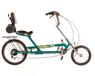
To the Town Centre on the Spirit Recumbent


A cloudy, slightly breezy day, a little cool for the time of year. First ride since my half century last week. Not going to break any records today.
Left out of the back gate, right into an estate road, then steadily pedalling until I reached an uphill right turn. The road then went left and levelled out. Speed gradually rose until I came to a T junction. Left here and downhill for some easy speed and gradually right and slowing down on the level again. Very little traffic about, making the ride very pleasant.

Soon I came to a place where the road began a steady climb up to a junction with the A 54. Near the top a very upright cyclist came the other way, presumably electric. I wondered if he looked down on mere leg powered cyclists. Though realistically, with a seat height of about 24 inches most people have to look down on this bike.

Just before the junction was a right turn so I turned right then left on to the pavement. I followed this round to where it paralleled the A54 uphill. There was no one on it apart from a distant chap on a mobility scooter. I pulled over when I reached him to let him past. On the flat, approaching the A54 roundabout, I turned right, got on the road then left to sweep round the roundabout onto the downhill dual carriageway. Still not much traffic, what there was gave me plenty of room, and I was able to change lanes and go to the filter lane to turn right at the next lights without any trouble.

I called in at the surgery to drop off a prescription, nipped into a nearby supermarket after chaining to a pillar, then back across the road, via a service road to the precinct. After calling in at a chemist after locking up to a floral pillar
Spirit and Floral Pillar.JPG

I went downhill to supermarket No 2, locked up, dived in then out, unlocked, then across the car park. Me, I don't hang about (though my average speed readings tend to disagree).

Left at the exit roundabout, right at the next to Dingle Lane to test my suspension on its speed humps, across the pavement at the end, through an estate road, right on Gladstone St, Townfields road. Up the long hill just as the sun came out, getting unreasonably hot. Face burning with the effort, I was grateful when the slope eased approaching the traffic lights at the top. Left downhill, something going on at the pub opposite my usual turning, cars all over the place, so I went straight on. I turned round further up the road, then came back and turned off. I had intended to stop and take a picture of the bike with wildflowers, as there were many more this year by the junction than last year, but there was a car parked not only on the pavement but on to the grass and flowers. Perhaps I should have taken a photo of that instead.

I tried not to let that spoil my ride as I freewheeled mindfully through the lanes to my back gate.

Since my last ride I’d replaced the folding pedals I’d been using with some old free spinning BMX pedals. The pedalling felt more direct with these though as they’re more chunky it might benefit from moving the seat back a fraction. I’ll ride it a bit more before I change anything.
I always feel better after a bike ride

4.31 miles. Max 23.9 mph. Average 7.9 mph. According to Garmin.
Ascent 159 ft. According to Bikehike
 

a.twiddler

Veteran
Tiny Ride Today
8/7/24
On the Spirit to the Town Centre again


I was expecting rain today but it’s been intermittently cloudy with sunny spells. I’d been to the town centre in the car earlier as I’d had some bulky items to drop off but forgot to pick up something else on the way back. I decided to cycle as I’d been itching to get out again since my last ride. This bike has certainly grown on me since I’ve been using it for longer trips.

Out through the back gate, right along the lane, eventually reaching Swanlow Lane and the uphill traffic lights, intending to head into the right hand lane to turn right. A car was behind me, undecided whether he was going to pass, so I just stuck my hand out and moved right, then waited as the light turned green, uncomfortably sandwiched between oncoming traffic and traffic passing on the left, waiting for a gap so I could turn.

A gap appeared, off I went, then left again downhill for the town centre. I’d warmed up approaching the traffic lights so as the speed rose my temperature dropped. A red Audi had to go rasping past even though he had to slow down again behind the next car ahead. I was right behind him most of the way, powered by gravity, until he turned left at a mini roundabout, and the rest of the traffic and I went straight on to the town centre.

Straight through the next lights then right into a service road at the end of which I hopped off and walked the bike into the precinct. I locked up to a floral pillar, went to collect my item, then wheeled back to the service road. Out on the road again, I turned right to the next set of traffic lights. Left here, along a short roadside bike lane separated by a white line. Where this ended I got onto the pavement and began to pedal up the long hill.

Soon after I got on to the pavement there were excavations marked by barriers which narrowed the space available to single file. After waiting for some oncoming pedestrians to pass I ran the gauntlet. The route was not straight, at times I was travelling at less than walking speed and found myself unconsciously shimmying the bars to stay balanced. I got through without bumping the barriers or having to stop. After that it was plain sailing. Despite being a long hill it’s not as steep as other routes out of the centre and I made reasonable progress. Even though the day was warming up there were shady trees dotted about. Near the top where the pavement curves round to join Swanlow Lane there is a green area with a bench and a paved path that cuts the corner. I followed the path . Ahead, an old lady with a shopping bag and a walking stick was walking slowly along the path. She stopped to change shoulders with the bag then carried on. She did this several times. I stopped in the shade to give her time to go round the corner.

Once I reached that spot I got on to the road and carried on along Swanlow Lane. For a change I turned right on to Beeston Drive and after a short up gradient enjoyed the level then a downhill. In the far distance, a tiny speck which is the crag on which Beeston Castle stands, hence the name of the road. Depending on the weather, it is more visible on some days than others.

After some downhill, a left turn, some level then a swooping downhill, before long I was at my back gate. It felt like more than three -odd miles, but then it always does. No photos today.


Mileage 3.09. Max Speed 23.5 mph. Average speed 7.2 mph. According to Garmin.
Ascent 125 ft. According to Bikehike.
 

Conrad_K

unindicted co-conspirator
I'm a new rider, so all my rides are short until I get used to things. I have a long-wheelbase recumbent that I ride locally, and a recumbent tadpole I ride on the cycle trails at the state capitol area. It just worked out that way.

I got up at 0400, did my morning stuff, loaded the tadpole into the back of the truck (I really should have done that yesterday afternoon), and headed off to the gas station to put air in the trike tires and gas in the truck. Then a 30-odd mile drive to the trailhead. By the time I got the trike unloaded it was 0600.

The Riverfront Trail area is maintained by the cities of Little Rock and North Little Rock. (Arkansas, USA) According to their web sites, there are over 200 miles of paved trails looping through the cities, primarily along the riverfront area. All of them are "dual use" cycle/pedestrian, and seem to have about equal numbers of each, from the times I've been there. There are also two bridges over the river for cycle/foot only, the Clinton Bridge, which is a converted railroad bridge, and the Big Dam Bridge, which was built expressly for cycle/foot use. Big Dam has its own web site; it's 4,226 feet long and 90 feet high, 1.3 kilometers by 27 meters, more or less. It's the largest purpose-built cycle bridge in North America. There are a further three highway bridges with cycle lanes, set off by concrete barricades. So you can loop around the bridges in various patterns.

Anyway, I parked at the trailhead I use most often, turned the "make movie" mode on in the phone, stuck it in its cute little holder on the front of the trike, and took off. I rode from the trailhead I parked at toward the Clinton Bridge, then back over the Broadway bridge, then back to the truck, in an hour and a half. The "make movie" thing failed again, for some reason. It works at home. Maybe it hates the trike.

Though the cycle trails are extensive, they're largely unmarked, and not quite complete - the loop I took still had one section where I had to take the street for about a hundred yards. Coming over the Clinton Bridge and headed back, there would have been at least half a mile of congested (Main Street! At the capitol!) street with parallel parking, except at 0645-ish the sidewalks were empty, and riding on the sidewalk is specifically allowed here.

As far as the "unmarked" part, I lost the trail three times and had to double back. Even an arrow painted on the ground would be handy. I don't want to sound ungrateful, but neither city has any maps on their web sites, nor have I found any online. There are only a handful of videos of the Riverfront on YouTube, but they're all chopped up and out of sequence, which doesn't help.

I go there early to avoid traffic. The state Highway Department likes to tie main roads into knots and dig up old roads; the only way to get there is through "the Whirligig"; the intersections of Interstate 40, Interstate 30, and US 67. While the speed limit is posted at 50mph now (used to be 65), traffic generally rolls along at 75 or so, bumper-to-bumper. When I was 30 it was an annoyance, at 65, I prefer to avoid the mess as much as possible.

Anyway, it was a nice ride. I need to tweak the adjustment of the left handlebar some more. The right front brake is making an odd sound that needs to be investigated, as well as pulling to the right. The seat cover doesn't want to stay tight; it's held on with a drawstring and "stopper" thingamabob. Good thing I made that trike stand a couple of weeks ago...
 

Solocle

Über Member
Location
Poole
Last time I was in London, an assortment of tiny rides and one moderate one.
1720952929945.png

First up, after catching a circuitous overground route than onto Thameslink, disembarking at Brent Cross West and going to Golders Green for brunch. 2.7 km.
Rd22pBcRB6CTCOnQHnJLptjNLlJ-kiNm7xT90sBs-2048x1536.jpg

_w4jpkfIWJiLAuhdrEtXd95S7kyM14Cq0dX4xJh8-2048x1536.jpg

After that, it was the main tiling stint, which was curtailed to 13 km due to time. Oh well. But then it was time to do some shopping, so caught a train back to Brent Cross West, and then out-and-back to Golders Green. 5 km. Posed beside the North Circ (I have actually ridden this section in the other direction in the past... filtering through a traffic jam ^_^ ).
yKK-1N0bN5opL8ueVfDcoM9USzWav-rigC6DO1fs-2048x1536.jpg

Finally, it was a Thameslink serivce to Blackfriars, rather than dealing with overground shenaningans again, and a 1.2 km ride back to Waterloo.
lr3ezzdFyJT6bdphulBPwfa1JM2aUBkx3UQvx5hY-2048x1536.jpg
 

Conrad_K

unindicted co-conspirator
Another ride this morning. A few days ago a friend showed me how to get to the Big Dam Bridge trailhead. I had to go to Little Rock to do some database work early this morning, and when I was done I drove over there since the trike was still in the back of the truck. The bridge is a few miles off Interstate 40, basically in the middle of nowhere, and there are city employees around, as it is next to the city hydroelectric plant. I felt a lot better about leaving the truck there unattended than I did at the other trailhead.

Yes, the bridge is 4,226 feet long. What I failed to consider is that's a loooong way uphill. I'm still a newbie rider, so I kept gearing down as I got tired. I had passed an elderly man walking with a cane near the start of the bridge; about halfway up, he passed me. The trike is geared very short, but I didn't realize that was slower than a slow walking pace. On the other hand, trikes don't fall over when they're barely moving, and I made it to the top without having a stroke. And I passed Cane Guy again on the way down, which I will count as one of life's minor victories.

I resisted to urge to shout "yee-haw!" and see if I could break the sound barrier on the way down; the ends of the bridge curve 90 degrees at the approaches, and I didn't want to leave a Wile E. Coyote splash mark on the concrete wall.

The south side of the bridge splits to a paved trail on the left and a two-lane road with a bike lane on the right. I saw three other tadpoles and a delta; first delta I've seen while riding the trail. No two-wheel recumbents this time.

For some reason almost everyone was riding the bike lane on the road, mostly uprights with fully-geared riders hunched over the bars, being Very Serious. I met two bikes and a handful of walkers on the bike trail. And the usual Tactical Assault Ducks giving me the stink-eye when I rode by, but at least they weren't blocking the trail this time.

I had the other phone with me this time, with the idea of using it as a camera. Unfortunately the screen is almost invisible in daylight, and there was no shade handy. Next time I'll bring my old digital camera, which *does* work in daylight.


So, nothing spectacular to report, just a nice ride.
 

a.twiddler

Veteran
Tiny Ride Today
16/7/24
Spirit Recumbent to the Shops, again.


Rain stopped for a while, things even starting to dry out, so I thought I‘d nip to the shops on the Spirit. Grabbed the Garmin, threw a cap and track mitts on. Out through the back gate, soon heading for the uphill traffic lights on Swanlow Lane. I was going straight on today, and slowed down as the lights went red. No rush to get to the line, slowly uphill in the cycle lane, then the green came and I slowly accelerated over the junction and plodded on to the mini summit and downhill towards the A54 roundabout. A young couple came towards me on the pavement, the man merrily expounding about something and pointing to the buildings as they went past while the woman seemed to have switched off though smiled to herself as I went by. I came up behind traffic on the traffic light controlled roundabout and stopped briefly before following it round to the downhill dual carriageway. I pedalled furiously downhill in top, feeling that this was one of those rare occasions when I could have done with at least one higher gear. With a 16” bottom gear which I haven’t needed to use yet, it’s tempting to think that another tooth or two on the front chainring might gain something without giving up too much on the bottom end.

My efforts were in vain, as a red light loomed at the next crossroads. I haven’t got through this set of lights yet on a bike without stopping. A pity, as the road continues downhill. I got going with the traffic, got into the right hand lane, then right again into the filter lane to wait at another red light. Right here, right at the next two mini roundabouts into a supermarket car park and locked up to a barrier.

A quick in and out, unlocked, back across the car park, left at the exit roundabout then right at the next into Dingle Lane. The exit from Dingle Lane via Weaver St is closed to through traffic so only residential traffic is using it, making for a quiet trip to the end. Over the pavement., into an estate road, out to Gladstone St and Townfields Rd. Only a short ride but still a bit of a workout as all roads home are uphill.

Levelling out, left at the lights on Swanlow Lane, down the dip then unable to turn as a monster tractor with a tanker trailer full of slurry was turning. I went straight on up a slight uphill and turned round when the traffic thinned. The tractor and its load had made its impression with a pungent stench floating in the air. Like meeting someone emerging from the loo saying, “I’d give it a few minutes if I were you”, I hung about a bit before following in its wake. I imagined it being followed by a cloud of flies as it went along, perhaps with a tiny sign on the back which only flies could read, saying, “Eat at Joe’s Cafe. Ten million flies can’t be wrong”.

Fortunately, I never caught up with that mobile bucolic pong factory before I reached my back gate. It’s nice living in the countryside, but it can get mighty whiffy at times.

Distance 3.51 miles. Max Speed 25.7 mph. Average 8.5 mph. According to Garmin.
Ascent 112 ft. According to Bikehike.
 

Conrad_K

unindicted co-conspirator
Another ride this morning. I got out at 0630, just after sunrise. I was riding the recumbent bicycle instead of the trike, since local sidewalks are much narrower than the Riverfront trails, plus they're not contiguous, and it's easier to "portage" the recumbent between discontinuous sections than it is with the trike.

I *did* get pictures this time, but now my phone isn't talking to my desktop. I vaguely remember something about weirdo USB cables needed for that. I'll follow up on it later.

Anyway, there's a more-or-less square block of nowhere just north of where I live. Roughly two miles per side, no roads through it, nor any apparent trails. I've always thought it turned into swamp somewhere just out of sight, but I really don't know. I should probably use Google Earth and take a look.

I made 3/4 of the loop when my wife called and wanted me to go to the grocery store. Serendipitously, I was right at the optimum place to turn 90 degrees off the loop and head off to the store, which was a couple of miles east. I got milk and cereal and put them in the panniers I got last month. First time I've used them.

When I walked up to the bike a woman came up and said "That is *so* cool!" First time anyone has done anything besides stare.

I got back an hour and a half after I left. A few weeks ago I would have been half-dead from all the pedaling; this time, no problem. I'm getting the hang of this "bicycle" stuff.

Here's a picture of a 1997 model from an old ad brochure. Mine's a 1995 with a different paint scheme. The tailbag was standard equipment on all models; it's just the right size for my cable lock.
 

Attachments

  • 1997.077-Side-Rgt.jpg
    1997.077-Side-Rgt.jpg
    93.6 KB · Views: 7

Gunk

Guru
Location
Oxford
Another ride this morning. I got out at 0630, just after sunrise. I was riding the recumbent bicycle instead of the trike, since local sidewalks are much narrower than the Riverfront trails, plus they're not contiguous, and it's easier to "portage" the recumbent between discontinuous sections than it is with the trike.

I *did* get pictures this time, but now my phone isn't talking to my desktop. I vaguely remember something about weirdo USB cables needed for that. I'll follow up on it later.

Anyway, there's a more-or-less square block of nowhere just north of where I live. Roughly two miles per side, no roads through it, nor any apparent trails. I've always thought it turned into swamp somewhere just out of sight, but I really don't know. I should probably use Google Earth and take a look.

I made 3/4 of the loop when my wife called and wanted me to go to the grocery store. Serendipitously, I was right at the optimum place to turn 90 degrees off the loop and head off to the store, which was a couple of miles east. I got milk and cereal and put them in the panniers I got last month. First time I've used them.

When I walked up to the bike a woman came up and said "That is *so* cool!" First time anyone has done anything besides stare.

I got back an hour and a half after I left. A few weeks ago I would have been half-dead from all the pedaling; this time, no problem. I'm getting the hang of this "bicycle" stuff.

Here's a picture of a 1997 model from an old ad brochure. Mine's a 1995 with a different paint scheme. The tailbag was standard equipment on all models; it's just the right size for my cable lock.

Looks like a Raleigh Chopper in italics
 

Conrad_K

unindicted co-conspirator
I should probably use Google Earth and take a look.
So I did. Google Maps shows a Y-shaped road connecting two corners to the opposite side, but I rode right past all three places it supposedly connects to the main road and didn't see any sign of it. Though I admit I was watching more carefully for frost heaves in the sidewalk than mystery roads, since those big steps are a big deal when you hit one on a recumbent, which feeds the impact right up my spinal column.

I tried an aerial view with Google Earth. That seems to only work with Google Chrome now. They had a 2015 image showing a HUGE Y-shaped dirt road, that I should have passed within twenty or thirty feet of. Huge as in, maybe twice as wide as some of the nearby house roofs on the map. But to paraphrase Sgt. Schultz, "I saw nothing!" Maybe it has grown completely over in the nine years since the satellite image was taken. But it's something to look for on the next loop, anyway.

addendum: the map and satellite image show nothing but trees out there, other than the Y-shaped road.
 
Top Bottom