The CC Trig Point bagger thread, now incorporating other interesting geographs

Page may contain affiliate links. Please see terms for details.
Tuesday 6th
12.

The Crimea Tavern
Saville Road
Castleford
West Yorkshire

Once, one of the many thriving pubs in the town
Apparently, it had thriving music nights
it backs onto the River Aire

Possibly squatters are in there??


IMG_9096.jpeg


https://www.geograph.org.uk/photo/610853
 
Last edited:
Monday 12th
1.

Benchmark
Altofts Road
Normanton
Wakefield

I pass this every working day, unless it’s dry enough/light enough to consider NewLands Woods
I’ve never even thought about it before, for this thread, despite seeing it countless times

It’s to the right, of the red-signed mail-bar
IMG_9158.jpeg


IMG_9159.jpeg


https://www.geograph.org.uk/photo/7173096
 
Last edited:
Wednesday 21st
2.

(Dog walking in the afternoon)

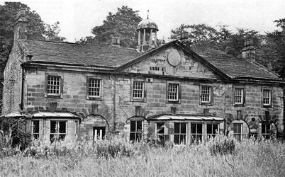
NewLands Hall Stable-Block
NewLands Woods
(between ‘Stanley Ferry’ & Normanton)
Wakefield

IMG_9258.jpeg


Some of the stone-setts in the stable yard, are still there, under the mud (looking back towards the site of Park Lodge, & NewLands Lane)
IMG_9255.jpeg


Some of the fencing too
IMG_9260.jpeg


The stables are to my right
IMG_9257.jpeg


https://britishlistedbuildings.co.u...rmer-newland-hall-newland-with-woodhouse-moor
Late 1890s/pre WW1; https://maps.nls.uk/geo/explore/#zoom=17.2&lat=53.69764&lon=-1.44657&layers=168&b=1
https://www.geograph.org.uk/photo/190194
http://www.lostheritage.org.uk/houses/lh_yorkshire_newlandhall_info_gallery.html

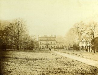
The Hall was demolished in the 1920s, but the stables were lived, into the (I understand) 1970s
I've seen this photograph in a local history book before, but (until now) never seen it online
NewLands Hall Stables. 1.jpg

This is possibly circa 1900-1910?
NewLands Hall. 1.jpg
 
Last edited:
Friday 23rd
1.

Whilst out dog-walking

St Johns Colliery Bricks
NewLands Estate
Altofts
Wakefield

I'd passed the site of the brickworks en-route, & this location is less than a mile away in a straight-line'
The family owning the NewLands Estate, also had part-ownership of the Colliery (in the late 1800s/early 1900s)

IMG_9281.jpeg


https://maps.nls.uk/geo/explore/#zoom=17.3&lat=53.69527&lon=-1.43327&layers=168&b=1
They're probably somewhere near the 'N' of 'Normanton', on the OS map below the photograph; https://www.geograph.org.uk/photo/2762301
The old chimney is still there, supporting telephone equipment; https://www.geograph.org.uk/photo/3675566
 
Last edited:
Last edited:
Top Bottom