You are using an out of date browser. It may not display this or other websites correctly.
You should upgrade or use an alternative browser.
You should upgrade or use an alternative browser.
The CC Trig Point bagger thread, now incorporating other interesting geographs
- Thread starter Drago
- Start date
Page may contain affiliate links. Please see terms for details.
Richard A Thackeray
Legendary Member
Not sure if I've added this one before, but I'm not trawling through 120+ pages
Marked 'Horbury/Crigglestone'
Behind the fence is a beck (stream) that would have been the Parish boundaries
(Saturday 6th June 2015)
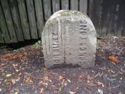
It's by the fence, at the bottom of the hill, on the right
http://www.geograph.org.uk/photo/4791110
Marked 'Horbury/Crigglestone'
Behind the fence is a beck (stream) that would have been the Parish boundaries
(Saturday 6th June 2015)

It's by the fence, at the bottom of the hill, on the right
http://www.geograph.org.uk/photo/4791110
Last edited:
Richard A Thackeray
Legendary Member
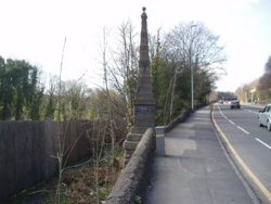
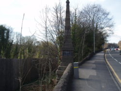
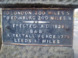
Leeds Forge
Kirkstall Road (aka A65)
Just on the Horsforth side of Kirkstall Abbey
http://www.geograph.org.uk/photo/96799
The 'Forge' is a huge site, now turned over to housing
Not sure of the year, could be anytime up to the 70s'
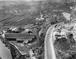
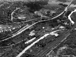
Kirkstall Road (aka A65)
Just on the Horsforth side of Kirkstall Abbey


http://www.geograph.org.uk/photo/96799
The 'Forge' is a huge site, now turned over to housing
Not sure of the year, could be anytime up to the 70s'


classic33
Leg End Member
Don't believe this to be one, opinions?

On the same building. You can tell you were in a posh area when you saw these, either side of the doorway.

Listed as 19 Bull Close Street

Also at 19 Bull Close Street, listed as 19 High Street.

Flats 8 - 12 Hopwood Lane. Four foot in from the corner on the East wall.

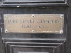
1 & 2 Lord Street Chambers. Listed as 36 Bull Green. 36, 34 being the last one before Hopwood Lane/Lord Street/Bull Green junction.

Not a new sign
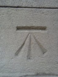
The only mark left on the site of Saint Mary's(CofE) Church, on the Lister Lane side.
Wall cut & rebuilt in places

Freemason Lodge Mark removed in edit
On the same building. You can tell you were in a posh area when you saw these, either side of the doorway.
Listed as 19 Bull Close Street
Also at 19 Bull Close Street, listed as 19 High Street.
Flats 8 - 12 Hopwood Lane. Four foot in from the corner on the East wall.
1 & 2 Lord Street Chambers. Listed as 36 Bull Green. 36, 34 being the last one before Hopwood Lane/Lord Street/Bull Green junction.
Not a new sign


The only mark left on the site of Saint Mary's(CofE) Church, on the Lister Lane side.
Wall cut & rebuilt in places
Freemason Lodge Mark removed in edit
Last edited:
Drago
Legendary Member
- Location
- Suburban Poshshire
Meanwhile, back on the hunt..
View attachment 399992
View attachment 399993
A couple of Year bricks on a bridge over the Grand Union canal near Arm Farm.
View attachment 399994
And a wonky Utility Marker near Knock Lane, Blisworth.

Knock Lane is only a few hundred yards from Daughter #3's house. I may bimble up there and rescue that marker before it is lost to posterity.
classic33
Leg End Member
There's one screw still holding it in place.Knock Lane is only a few hundred yards from Daughter #3's house. I may bimble up there and rescue that marker before it is lost to posterity.
And there's a flat plate still awaiting postage!
Head down towards Stoke Bruerne and it’s on the left just before the bridge.Knock Lane is only a few hundred yards from Daughter #3's house. I may bimble up there and rescue that marker before it is lost to posterity.
Drago
Legendary Member
- Location
- Suburban Poshshire
Roger, I know where you are. Depending on how the Beast From the East II hits I may head down there Saturday.
classic33
Leg End Member
You could go underground on Saint Patrick's DayRoger, I know where you are. Depending on how the Beast From the East II hits I may head down there Saturday.
Datum2
Über Member
- Location
- Huntingdonshire
It was only through cycling in Oundle that I noticed this mile post sign. Located near the narrow part of North Street where the traffic lights are located.

biggs682
Itching to get back on my bike's
- Location
- Northamptonshire
It was only through cycling in Oundle that I noticed this mile post sign. Located near the narrow part of North Street where the traffic lights are located.
View attachment 400470
Good spot
biggs682
Itching to get back on my bike's
- Location
- Northamptonshire
@biggs682 I checked the boot fair entrance in Overstone but didn’t find anything interesting.
I think the entrance had been widened by the look of the stonework. Nothing on the nearby gatehouse either.
Must admit i have done the gatehouse a few times and hadn't found anything either

Bobby Mhor
Legendary Member
- Location
- Behind You
One year old today

apologies/thanks to trigpoint 100 for 'borrowing the photo'
