The CC Trig Point bagger thread, now incorporating other interesting geographs

Page may contain affiliate links. Please see terms for details.
I've just noticed that various scales/ages on the National Library of Scotland OS online site appear to show masons marks (that's what the symbol looks like)
Granted some buildings may not be there now/rebuilt

Have a look at this one, in the town I live it
It's marked as being on top of the railway bridge, over the very busy station/sidings, as they were then

http://maps.nls.uk/geo/explore/#zoom=18&lat=53.7021&lon=-1.4218&layers=168&b=1

I have checked with @Drago , out of courtesy, about adding what could be considered a 'spoiler', as he started the thread, & he's fine with it
 

classic33

Leg End Member
http://maps.nls.uk/view/125641996#zoom=4&lat=1906&lon=8545&layers=BT
&
http://maps.nls.uk/geo/explore/spy/#zoom=18&lat=53.7544&lon=-1.8984&layers=6&b=1&r=38
Everyone seems to be using the the point where the three paths meet and the current road junction for Edge End. The Trig Point is further North and on the Eastern side of where the wall was. The Traversing Point/Bench Mark/Boundary Post is on the Western side of the wall, slightly further South.
illingworth.jpg


@Richard A Thackeray, you've got me overthinking this again with that link!
 
Last edited:

Bobby Mhor

Legendary Member
Location
Behind You
I've just noticed that various scales/ages on the National Library of Scotland OS online site appear to show masons marks (that's what the symbol looks like)
Granted some buildings may not be there now/rebuilt

Have a look at this one, in the town I live it
It's marked as being on top of the railway bridge, over the very busy station/sidings, as they were then

http://maps.nls.uk/geo/explore/#zoom=18&lat=53.7021&lon=-1.4218&layers=168&b=1

I have checked with @Drago , out of courtesy, about adding what could be considered a 'spoiler', as he started the thread, & he's fine with it
@Bobby Mhor, see http://maps.nls.uk/view/125641996#zoom=4&lat=1906&lon=8545&layers=BT
&
http://maps.nls.uk/geo/explore/spy/#zoom=18&lat=53.7544&lon=-1.8984&layers=6&b=1&r=38
Everyone seems to be using the the point where the three paths meet and the current road junction for Edge End. The Trig Point is further North and on the Eastern side of where the wall was. The Traversing Point/Bench Mark/Boundary Post is on the Western side of the wall, slightly further South.
View attachment 398746

@Richard A Thackeray, you've got me overthinking this again with that link!
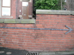
These marks were used as markers in many cases to point to water, sewage etc locations, I'm winging it on this this but I tend to see these arrow marks (without the top levelling marks) on much older properties than from when the OS started the 'mass' marking of levelling. This is my own view as I've not researched this any further, all a guess, I'm afraid.
Some of these marks are pretty brutally done.

@classic33
I've mentioned this before the triangle with a dot in the middle was used by map makers to signify a hill top in earlier days, OS just adopted the mark later as a Trig mark.

The NLS map resource is amazing and It's Scottish, keep out you southerner whippersnappers^_^
 

classic33

Leg End Member
These marks were used as markers in many cases to point to water, sewage etc locations, I'm winging it on this this but I tend to see these arrow marks (without the top levelling marks) on much older properties than from when the OS started the 'mass' marking of levelling. This is my own view as I've not researched this any further, all a guess, I'm afraid.
Some of these marks are pretty brutally done.

@classic33
I've mentioned this before the triangle with a dot in the middle was used by map makers to signify a hill top in earlier days, OS just adopted the mark later as a Trig mark.

The NLS map resource is amazing and It's Scottish, keep out you southerner whippersnappers
^_^
That's why there's a "Buy Button" at the bottom!
 
Last edited:

Bobby Mhor

Legendary Member
Location
Behind You
That's why there's a "Buy Button" at the bottom!

The mark isn't at the top of the hill. The highest point being West of the wall, North of both Traversing & Trig Point(which is now about six foot under).

I've spent the morning searching Google for a definitive answer,
I'm throwing the towel in..just now

Contact OS and maybe they can fill you in...
I'd a discussion on my blog about White trigs

Found this and point 5 is interesting

HERE
 

Bobby Mhor

Legendary Member
Location
Behind You
Extract from Ordnance Survey 1/2,500 Conventional Signs circa 1923
(first trig point erected circa 1936)
trig.png


Link to HERE

trig 96.jpg


Link to earlier circa 1896 HERE

Hopefully the 1923 one answers both Richard and Classic's questions form earlier, I assume other points (hill tops) were used for the purpose of triangulation pre 1936 when someone sat down and rethought the whole thing out.

Some asides about the trig pillar HERE HERE HERE

@Richard A Thackeray

Your NBM on bridge
SE 3826 2297 38.3743 N 2 3 0.3 1963 PARA RLY BR SW SIDE ALTOFTS RD 49M NW RD JUNC
 
Last edited:

Bobby Mhor

Legendary Member
Location
Behind You
Two today..

matched the coordinates and description,
Greenock, Bow Rd (Google Maps shows the levelling line better than my photo:blush:)
NS 2648 7603 Greenock, Bow Rd, Wall.jpg


Bridge of Weir, Torr Rd (normally fly down this road but have been recently doing the drag up to the B road)
Post is worn at the top but as previous, everything matches the description in the database.
There is something 'written' below the mark but can't make it out
NS 3669 6597 Bridge of Weir, Torr Road, Post.jpg
 

classic33

Leg End Member
Charlestown Road, on what was a goods yard
Wishful thinking?
CAM00881.jpg

Not as clear in the picture.
Approx 300 yards further on, and the last that will be seen on that side. (Road level raised some years ago, to even out the slope.)
CAM00882.jpg

Cross Hills, junction with Northgate/North Bridge, George VI freestanding box
CAM00883.jpg
 
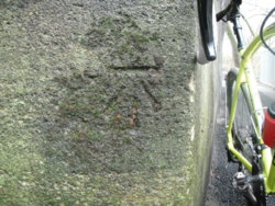
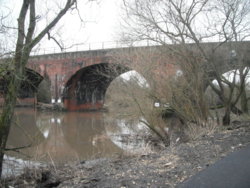
Whilst out/about today, & keeping an eye on some of the older buildings

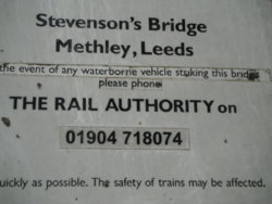
1. 'Stevensons Bridge'
Methley/Castleford
I'm never certain whether the implication is the famous father/son, of civil engineering/railways fame, but their name is with a 'ph'
http://www.geograph.org.uk/photo/3856541
https://cyclecityconnect.co.uk/projects/wakefield-to-castleford/
DSCF4472.JPG DSCF4471.JPG DSCF4475.JPG


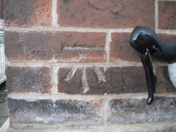
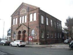
2. Baptist Chapel (1877)
High Street
Normanton
Bench Mark is on the corner
http://www.geograph.org.uk/photo/228719
DSCF4501.JPG DSCF4503.JPG


3. (junction of) Ashgap Lane & High Street
Normanton
An attempt to bring the sharp turn, that was here, before a re-alignment, to prevent vehicles heading down the steep Ashgap Lane
The house behind was a Doctors Surgery for many years
The arrow would be just behind the photographers right shoulder in this 'Geograph' image
http://www.geograph.org.uk/photo/4772024

DSCF4502.JPG
 
Last edited:
Top Bottom