Your ride today....

Page may contain affiliate links. Please see terms for details.

geocycle

Legendary Member
A three rivers ride today. The forecast was poor according to BBC whereas the sages of the MetOffice were slightly more optimistic. I took a punt on the Met Office but decided to stay at low level and hope the hills would catch any rain. It was really mild and I even had some sunshine. The roads were sodden and part flooded after heavy overnight downpours and I was pleased of mudguards and waterproof socks to keep the worst at bay. The outrun was along the Lune before jumping across to Scorton and the I headed south to Inglewhite crossing the Wyre near Garstang. The road rolled its way into the Ribble catchment and I decided to have lunch at Brockhole nature reserve. The approach involved a steep 20% descent down a muddy track with random section of cobbles so I was pleased to land along the shoreline of the flooded gravel pits. Unfortunately, that was also the way back and I had to push up a steep rutted section, I don’t know how the mountain bike folk do it. Back on tarmac I followed Preston Guild Wheel, a set of connected infrastructure comprising mainly shared paths. I eventually escaped Peston and made my way across the flatlands of Inskip, Elswick, Great Eccleston and Pilling. Not forgetting the 20p toll to cross the Wyre at Cartford. The rain held off until the last 20 km so not too bad for December. 102 km with just 628 m of climbing.

Pictures of bike by the Lune and Brockholes crannog-like visitor centre in Iron Age light

IMG_0820.jpeg


IMG_0822.jpeg
 
Last edited:

8mph

Veteran
Location
Devon
A second attempt at this route.

Screenshot_20241201_175705.jpg


Last time I bailed at 16.9 miles, this time I bailed after 22 miles.
I hope to complete the route next year sometime.

IMG_20241201_103148.jpg


IMG_20241201_113621.jpg


IMG_20241201_114935.jpg


IMG_20241201_120333.jpg


IMG_20241201_134625.jpg


IMG_20241201_142706.jpg


IMG_20241201_145416.jpg


IMG_20241201_152433.jpg


IMG_20241201_165641.jpg
 

sevenfourate

Devotee of OCD

Rickshaw Phil

Overconfidentii Vulgaris
Moderator
Yesterday: I got my brother out for a ride.^_^ He hasn't been out for a while so he didn't want to go too far or have too many hills to deal with. A bit of a tour round town seemed to fit the bill and he did drop a hint that he wouldn't mind a pub stop at some point. The day was pleasantly mild, especially for the end of November so no need for the winter layers I'd worn last time I was out.

Before we set off I thought it would be a good idea to have another look at the set up of his bike. As mentioned previously I'd fitted some new cranks to his bike and wasn't convinced that we'd got it set up right just yet. Using the heel on the pedal technique it seemed there was scope to put the saddle up further still so I did that and we set off. We had the gradient and wind in our favour initially but despite that, Doug seemed to be riding with an ease that looked very promising. We headed towards Sutton Farm, passing the new pedestrian crossing for the first time and not being very impressed - it appears to have been put in with no consideration of the the cycle lane on the road at that point and is hazardous in my opinion.:headshake:

Having reached Sutton Farm, Doug mentioned the back of his knee felt a little strained. Having had exactly this myself recently I realised that I'd set the saddle a bit too high. We paused so I could lower it a few mm then carried on with a meandering route through the estate and joined the old railway path to double back. We wound our way round towards Telford Way then cut through to Sydney Avenue where, as expected, the riverside path was blocked off due to recent flooding. I therefore took us past the old prison, into town via Castle Street and round the centre before ending up at Victoria Quay and joining the path through The Quarry. Plenty of people out walking and cycling but it wasn't as packed as the last couple of times I've been down here.

The promised pub stop was taken at The Coleham Tap where we really enjoyed the fact it was warm enough to enjoy sitting outside with our drinks. When we moved on again I thought I'd try a road I haven't ridden before which coincidentally goes past a pub that @gavgav has recommended to me - we didn't stop this time but it looks inviting for a future trip.

After that it was back onto familiar roads and cyclepaths heading back. Doug said he was getting quite tired by now yet he seemed to be scooting along at a fairly brisk pace with ease so I'm really hopeful I've got the set up about right for him now.

13.2 miles at 10.8 mph average. The average speed doesn't tell the whole story as this is not a fast route, but picking up a new Strava personal best on one of the climbs suggests we were going quite well.:okay: Enjoyed that.

20241130_144534.jpg
 
Started today’s ride next to the old railway station near Bois-de-la-Roche. Immediate access to the V3 Voie Verte and I headed south on the MASSI (my carbon-framed MTB) expecting some stony, muddy tracks later in the ride. Through Ploërmel, over the Pont-des-Deux Rivières, across the Oust flood plain and up the other side of the valley to le Pissot (where I’d left the GR347 two days ago – see upthread for details). Onto the GR347 and heading up and down hill on field tracks – I had to push the bike up some of the steeper slopes – before entering Malestroit from the west. I had a good potter around the centre of town – it’s so much calmer than the madness of the summer months.

Onto the Nantes-to-Brest canal and back northwards. Stopped at la Née for a snack then on to le Pont de Bagotais. Picked up the V3 again for a few km before leaving it by the Pont de Hingleux and rejoining the canal for the loop round to Montertelot. On to the Pont-des-Deux Rivières and back on to the V3 again – and then straight north back to the van at Bois-de-la-Roche.

67km in just over 4.5 hours. An enjoyable ride that has extended my coverage of the GR347 footpath and which has also completed my 2024 HMCAM challenge.

I never get bored of seeing @Rickshaw Phil 's photos of Caer Caradoc or @sevenfourate 's seascapes, so I hope you won’t mind if I post this view again: looking west from the Pont-des-Deux Rivières.

Pont-des-Deux Rivières looking west pic 3.JPG


On the GR347 between le Pissot and le Verger, looking back at where I'd come from

GR347 between le Pissot and le Verger, looking back.JPG


A couple of shots in the centre of Malestroit

Malestroit town pic 1.JPG


Malestroit town pic 5.JPG


Work is going on at the écluse (lock) de Malestroit – the towpath is currently closed (for about 3km) until early February next year

Crane at the écluse de Malestroit.JPG


This is one of my favourite spots – la Née, where the canal (in the foreground) leaves the Oust. It’s a serene location. I’ve taken dozens of photos here over the years but none seem to accurately capture the stillness/tranquillity.


le Née pic 4.JPG


Approaching Montertelot on the canal (also Eurovelo #1)

Montertelot from the south pic 2.JPG
 

ColinJ

Puzzle game procrastinator!
Another variation on a Battisborough loop. This time I went down the Preston bridleway. It was mucky. There was also the rare sight of 2 cyclists coming the other way.

Up the killer hill to Alston and back through to home via Bull and Bear.

Coming into the village Lisa was driving out to go shopping. I gave her a 2 handed wave, she’ll probably tell me off later!

https://www.strava.com/activities/13023525598

View attachment 754291

View attachment 754292

View attachment 754293

View attachment 754294

View attachment 754295

View attachment 754296
At least on that bike you stand a chance of getting through those Devon puddles/floods in one piece. The last couple of times that I tried (on narrower tyres and no suspension) I got punctures after hitting vast submerged potholes. One impact was so severe that it shook the fluid in my eyes loose and I have suffered from 'flashies' ever since!! :eek:
 

Dave 123

Legendary Member
A Battisborough loop in the dark.
At the bottom of Bridgend hill my bike light indicator went from blue to orange….

At some point it went red. I stopped at Battisborough and got the floodlight out of my rucksack.

My light had about 5 minutes left in it before I was plunged into darkness. A quick stop to put the floodlight on, the handle of it is perfect for holding while riding.

Cold clear and bracing.

https://www.strava.com/activities/13040264170

IMG_6895.jpeg
 

Rickshaw Phil

Overconfidentii Vulgaris
Moderator
I had really hoped to get at least a couple of rides in already this week but, as is often the case, other things got in the way. This morning I had a bit of time free and a gap before wet and stormy weather was forecast to arrive in the afternoon so grabbed the knockabout bike to head out.
My Acton Burnell loop was a safe choice of route and I was on the road at about half eight but not until having to bodge my brand new pedals as the plug on the end of the spindle on the RH side has gone missing.:thumbsdown: I'll check if I have a suitable replacement anywhere in my spares box, otherwise I may be talking to the vendor about warranty.

Heading over Lyth Hill to avoid the temporary lights on the A49 (looks like they may be there for quite a while) there didn't appear to be many people rat-running this time. I had to wait a bit to get across the main road but had a good gap when it did come. The back roads are all pretty dirty at the moment - the lane through Ryton to Longnor was pretty much as expected. I had a light tailwind through Frodesley to Acton Burnell, which is always nice. Nothing really to report on the way to Harnage and the flag at Cound was unchanged from the last time I came this way.

In Cound I needed to duck into a driveway for a couple of large tractors to pass and after they had gone decided on a whim to take the lane to Golding then back to Acton Burnell. This turned out not to be the best idea as the lane was covered in a layer of sloppy mud and gravel for pretty much all of its length. The bike is now really filthy.

Once back to Acton Burnell I headed for Pitchford then Cantlop. Some nice swift riding for a lot of it and I didn't do too badly on the uphill stretches. I thought I'd carry on to Weeping Cross then Meole Brace to head back, which worked out well.

27.6 miles at 12.3 mph average. 1494 feet of climbing. It felt pretty good to get out and the weather conditions weren't bad for it. Very few other cyclists out this time.

20241205_090403.jpg

A quick stop near to Ryton.

20241205_090631.jpg

In Ryton.

20241205_093853.jpg

At Evenwood.

20241205_095920.jpg

Mud, mud, glorious mud. En route to Golding.
 
Playing catch-up – here are some details of my ride on Wednesday.

It was very cold in the morning .. I was wearing three fleeces (two thin ones and a really thick Berghaus fleece that’s at least 40 years old but still does the job) under a windproof jacket and I had my thick winter gloves on. Started out again from the parking by the old railway station at Bois-de-la-Roche and headed south on Katie-Mae (gravel bike). It wasn’t until I’d crested the ridge south of Ploërmel and dropped down into the Oust valley that I finally started to feel less cold (and I could stopping blowing warm air into my gloves).

Pulled off the V3 at the site of the old railway station in Pleucadeuc and took the D112 into the centre of town. I picked up the VAB trail (Voie Abbaye de Beauport pilgrimage trail) heading south, initially along a sandy path then into the woods on a stony track. I knew that some of this would be “off-road” but unsure exactly how much of it there’d be .. I probably should have been on one of my mountain bikes but that would have slowed me down getting to and from Pleucadeuc and I wouldn’t have had time to do everything before nightfall.

A left than a right took me to the hamlet of Kerantoine. Muddy but OK. Thereafter it got silly. The track ended up in a fly-tipped pile of bricks and sand. The path continued the other side, weaving in and out of trees, fallen branches, nettles and brambles. We got through it very slowly. Then the path ended in front of a very large field. There was about a one-metre strip of grass running straight ahead between two fields of sown wheat. Almost impossible to cycle on so I pushed the bike for about another 800 metres before reaching another track that led east to la Maraudière. I’d been at the other end of this track earlier in the year .. it had looked OK then but in the depths of winter, just more mud and cowshit to get through. We did get through it .. but the bike was muttering “I didn’t sign up for this…”.

At last, back onto a tarmac surface and heading south in the general direction of Rochefort-en-Terre. I’d no intention of going as far as that today – the plan was just to explore the countryside between Pleucadeuc and Rochefort. Came to a X-roads about 1.2km further south. I’d thought the VAB went straight across to la Berthé but as soon as I’d carried on, large ‘X’s told me I was wrong. Too tired to care and I knew that I could check the website in the evening for the correct route and pick it up at a later date.

Headed west on the C2 toward the outskirts of Molac then north on the D149 to rejoin the V3 a couple of klicks south of the old railway station at Pleucadeuc. Stopped here to munch a piece of millionaire shortbread and to calculate how far back it was to the van and how much daylight remained. I reckoned it was about 37km to go with about two hours of reasonable light left. That meant I didn’t have to cycle like a maniac and that I could stop for another snack or a drink if I needed to.

Back at the van just as it was getting quite dark … I was relieved as there are no street lights where I’d parked.

A really good day out, despite the cold in the morning and the muddy section of the VAB.

91.49km in just under six hours of cycling (plus walking and swearing).

The VAB trail just south of Pleucadeuc

On the VAB south of Pleucadeuc pic 1.JPG


On the VAB south of Pleucadeuc pic 2.JPG


The large field that I had to push the bike across

On the VAB south of Pleucadeuc pic 3.JPG


The aire de pique-nique at Pleucadeuc's former railway station (where the platform was, I imagine)

Picnic area at Pleucadeuc gare.JPG
 

Rickshaw Phil

Overconfidentii Vulgaris
Moderator
With Storm Darragh rolling through yesterday, getting out for a ride was a non-starter. Today though it was dry and although still pretty windy it wasn't the howling gale we'd had so I ventured out. A longer ride was tempting but a short and easy route was sensible so I went for a regular route into town then out to Upton Magna, Atcham and Condover.

The cycle paths have plenty of small debris on them and there were odd missing bits of fence in places but otherwise we didn't seem to have fared too badly from the storm locally. The people the other side of the village who were without power until the early hours this morning may disagree though. I headed into The Quarry via Porthill and found the river quite high - it is across Victoria Avenue underneath Kingsland Bridge but I'd intended to have a bit of a detour up to St. Chad's to see how the Ebenezer Scrooge gravestone looks now that it has been repaired after being vandalised: https://www.bbc.co.uk/news/articles/c8dmzj6j7e0o

Moving on again I returned to the riverside and, after needing to splash through a couple of small floods, headed over the English Bridge. I got held up a little near the Abbey by a driver who I think was probably lost. When they let me past I thought I'd carry on along Underdale Road then the path that connects to Telford Way for a change. Another change was to avoid the muddiest part of the old canal path and take the longer way round using Whitchurch Road and Field Crescent before rejoining the canal path to Uffington.

Having a tailwind was nice to Upton Magna and Atcham where the road to Cross Houses was closed due to flooding and meant a detour. I still had a couple of water splashes to get through despite that and the remains of a tree to avoid. There seemed to be more frequent fallen trees on the run to Condover but they all seemed to have fallen away from the road so didn't cause any bother.

Turning back towards the wind it was pretty cold and took some effort but it wasn't too far to go now via Little Lyth.

22.2 miles at 11.1 mph average. Strava shows 1035 feet of climbing. A ride that I needed even if it was cold and hard work on the bits against the wind.

Edit to add: I forgot to mention that I found what looked like a suitable plug to replace the missing one on the RH pedal as reported last time - it needed some trimming to fit and it has stayed in for this ride. Hopefully it'll do the job.

20241208_132858.jpg

A swollen River Severn in The Quarry. It's not expected to peak until sometime tomorrow.

20241208_133135.jpg

St. Chad's

20241208_133232.jpg

I usually get a pic of this about this time of year.

20241208_134119.jpg

Shrewsbury Abbey.

20241208_141441.jpg

Upton Magna.

20241208_142618.jpg

The new bridge at Atcham.

20241208_142819.jpg

As usual I can't get that way. Will have to go round.

20241208_142944.jpg

Someone has taken advantage of the stormy weather to do some fly tipping.:thumbsdown:

20241208_145547.jpg

Condover.

20241208_150148.jpg

A couple of new hazards on the golf course at Condover.
 
Last edited:

lazybloke

Today i follow the flying spaghetti monster
Location
Leafy Surrey
Time on the bike has been short recently, but I had an unexpected clear day today (Tues) and headed down to Sussex by car to start a decent ride on quiet roads.

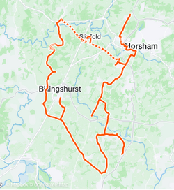
Had a Garmin mishap - the route was on my phone app but somehow I'd transferred another (similar) route to my head unit; I only realised when I was 6 miles off course. Had a sarnie from Tesco whilst considering my options and decided to backtrack the 6 miles, then freestyle the rest of my ride.

It wasn't the only detour - there were road closures due to floods and fallen trees, but surprisingly the Downslink cyclepath had no such problems; it was drier and less muddy than it had been in the summer!

So my distance gradually increased, and the cold slowly crept into my fingers and toes (temps were down to 3 C). Most of the roads I'd opted for were empty of shops, so I nearly detoured to a town for a hot drink; but the thought of going outside into the cold and dark afterwards was hell, my leg muscles were already sore and fatigued.
So I opted to go straight back to the car, reaching it at lighting up time.

Took an hour to drive home, with the heating on full blast, but I was still cold until I'd had 3 mugs of tea, toast, and a hot shower!


Total distance was 84 km in 4 hrs 9 minutes of "moving time". Had originally planned 100km, but I had no enthusiasm for that.
Also bagged 16 new veloviewer tiles, which increased my max cluster by 35 tiles. There's weird maths for you.
An enjoyable day, but shoe covers and warmer gloves next time.

1733874147158.png


Puncture risk!
1733874203364.png


Danny MacAskill would ride on those parapets!
1733874343300.png


Non-muddy Downslink
1733874406898.png

Spot the wiggles for "veloviewer squares"!
1733874490998.png
 

Attachments

  • 1733951145043.png
    1733951145043.png
    157.7 KB · Views: 0
Last edited:

Marchrider

Well-Known Member
My very first ride since joining Cyclechat, my very first ride this month - had the flu or covid or something (probably covid with wierd smells and tastes that I don't quite understand)

Never mind, got myself back on the road for a few miles, very cold, +1 when I set off and 0 when I got back, but it was dry and a bit of sun
1733959366110.png

bloody scarey going into a low sun, I get get off when I here anything coming from behind, you never know if they've seen you

esp with stuff like this flat to the mat
1733959575320.png


Still good to be back out on the road
1733959727065.png


I had been thinking this last few days I might fail my even reduced target for the year - started off as 6500, then a month a go I reduced it to 6000 mile, and then with this december lay off I thought I would miss that too

but todays 14 mile takes me up to 5917 - surely I can manage another 83 before the end of the year
 

sevenfourate

Devotee of OCD
My very first ride since joining Cyclechat, my very first ride this month - had the flu or covid or something (probably covid with wierd smells and tastes that I don't quite understand)

Never mind, got myself back on the road for a few miles, very cold, +1 when I set off and 0 when I got back, but it was dry and a bit of sun
View attachment 755257
bloody scarey going into a low sun, I get get off when I here anything coming from behind, you never know if they've seen you

esp with stuff like this flat to the mat
View attachment 755258

Still good to be back out on the road
View attachment 755259

I had been thinking this last few days I might fail my even reduced target for the year - started off as 6500, then a month a go I reduced it to 6000 mile, and then with this december lay off I thought I would miss that too

but todays 14 mile takes me up to 5917 - surely I can manage another 83 before the end of the year

Great going !! Kudos Sir….
 

Rickshaw Phil

Overconfidentii Vulgaris
Moderator
Yesterday: A dry but cold morning beckoned and looked like a good chance to test out some fettling on the knockabout bike (a clean, puncture repair, lubed brake pivots, new brake blocks and changed the chain). I set out with the intention of doing a decent length route to Walcot and Cressage.

I headed through Little Lyth, as has been common lately, to avoid the temporary lights which look like they are going to be there for some time. I didn't avoid queues though as there had been a crash at Hunger Hill (a Jaguar well embedded into the back of a BMW) so the police were controlling traffic while they waited for the recovery vehicles to arrive. After that bit of excitement it was much more mundane through Condover and along Lyons Lane, although there did seem to be a scrambling event going on as I neared the Kingstreet crossroads.
Near Berrington I disturbed a buzzard which then flew along the lane with me for a short distance - I tend to forget how big they are until moments like this come along.

Although the wind wasn't strong it made the day feel much colder than the thermometer had said, and by Cross Houses I wasn't feeling the love for my planned route any more due to the cold penetrating the layers I had on. I decided to head along the A458 to Cound Stank then Cound instead which would still be a decent ride but would be about 10 miles shorter. The traffic on the main road wasn't too bad then the lanes were quiet if a little muddy in places. The flag at Cound hasn't changed the last few times I've been past and makes me hope that all is well with the owner, who usually likes showing off his collection.

My one and only photo stop was take on the way up to Harnage. When I was about to restart a rumbling coming up the road turned out to be a rather large articulated lorry so I waited to let them go first - it meant no traffic coming down the hill for a bit at least. I picked up a helping wind on the long straight at Cound Moor and in the dip approaching Evenwood heard a plastic clatter as one of the reflectors on my RH pedal fell off. I'm really not convinced about the quality of these new pedals, although I have liked using them so far.

Through Acton Burnell, Frodesley and Longnor things were uneventful. The lane to Ryton had plenty of cuttings on - in the village I encountered a tractor in between cuts and, as I overtook, I thought that he could have pointed the cutter away from the traffic, before realising that it was still running. Doesn't seem terribly safe to me.:eek:


Retracing my steps past Hunger Hill the broken cars from earlier had been removed just leaving a few bits. When I got home I found the other pedal reflector was on the verge of dropping off. Some tinkering needed to rectify that.

25.7 miles at 12 mph average. 1301 feet of climbing according to Strava. It was good to get out but that wind was just evil despite only being light. I'll take a spare layer next time.

20241211_111311.jpg

Looking towards the Wrekin from the climb to Harnage.
 
Last edited:
Top Bottom