Your ride today....

Page may contain affiliate links. Please see terms for details.

twentysix by twentyfive

Clinging on tightly
Location
Over the Hill
Yesterday's ride. The forecast had been good but as I parked at Caersws the clouds looked ominous. I readied myself but where was Andy G? After a bit I got him on the phone. He'd picked the wrong car park! Sorted we headed off straight into a lovely lane alongside the river. The valley narrowed and then we were faced with the first climb. Nice and steep it was to take us from the valley up to 1264 feet and over to Staylittle. Strange name is that, the Welsh version is Penffordd-Las. You choose. The nest bit of road is familiar from the Machynlleth ride we did a couple of weeks ago but we ignored the left turn for Machynlleth to continue north. We ran along the Afon Twymyn with the wind turbines not so far above turning well. Yes it was a windy day. At Llanbrynmair The old railway bridge looked disused. Then a train went over. Needs some weeding does that bridge. We began another long climb. The watershed was at 833 feet. But the real nasties were lower down the valley. Gradients which my granny ring objected to and slipped and slipped some more. Looks like I need a new granny ring for these rides. The last nasty had me walking as there was no way the chain would stay engaged. Rats! Now thoughts were turning to the big climb ahead. The Bwlch-y-Groes. First the hors d'ouvre and we climbed in an up and down fashion up the valley from Dinas Mawddwy. Then as we turned a bend in the road the full enormity of the climb is revealed. It's almost two miles long and doesn't drop much below 14%. The chevrons on the OS map do not lie. There are steeper sections and one tiny breather about have way. I managed my granny ring, and my heart rate but the granny ring gave me a lot of trouble over the last 1/4 and wouldn't engage. I had to walk on some of that. Rats!

It was very windy at the top so my jacket went on. I'd got used to that as we'd been suffering from quite a few squally heavy showers coming through. So we'd stopped to take jackets on and off most of the morning. I found a slightly sheltered spot to wait for Andy. He appeared riding strongly but as he stopped at the top another squall started up and up here (1788 feet) was not the place to be. Dropping off this hill way dodgy. The surface was dreadful and the wind was gusting strongly from the right. It was "take it steady" time. Back down safely we ran along the lane above Bala lake to meet several riders out for a potter, presumably around the lake. Bala (the official start of this route) was our cafe stop. There really aren't any others out in the wilds. So we refuelled with a purpose. It was nice to hear some Welsh spoken in the cafe too, and the squalls seemed to have stopped.

We headed north out town to turn for a steep steep climb to Caecynddelw. On this one my chain slipped and then fell off the granny ring. Immediately my bike began to run backwards! "Well this is new", I thought but it all went wrong as I fell off. No real harm done but for a sore wrist. Gotta larf haven't you? I scrambled up that little nasty and got going again to emerge on the B road to continue the climb. This time the gradient was a bit more benign to 1594 feet. There's a very very fast run off at the bottom of the descent right into a village. Always a tad exciting. But worse is the tiny left turn at the very bottom. Best to scrub off speed (46 mph) gradually and return to the lane I always think (having tried a few times over the years). This lane is tiny and pretty rough but it takes us away from a slightly trafficked B road.

We rode briefly in the Tanant valley before turning south and straight up out. Two more long steep climbs where managing the granny was paramount. Somewhere in the middle of that there was a gated road where a dismount was required to open and close the two barriers. This one topped out at 1180 feet and was to be our highest point of our ride on the way back now. Not that it was easy. We were up and down constant steep hills in narrow lanes. We were in very rolling countryside with deep valleys and hills between. No flat to be seen. On one hill my rear tyre slipped several times due to the slime which was optimally wetted under the trees. Nearly another off or three. I'm glad I didn't descend that one. Andy had the same problem. I kept looking at the computer. 30 miles to go became 25, then 15. That's a sure sign that the scenery wasn't helping. I kept working out how many more hills could be fitted into those distances. Not good thinking really. I asked Andy. "Knackered" he said. But our pace, while not fast hadn't slowed too much (on average). At least the squalls had stopped apart from one brief one. The wind which should have been hindering was completey nulliffied by the hedges and the hills. I always say if you don't like wind head for the shelter of the hills. An open valley is a severe invitation. The sign saying Caersws 3 miles pointed downhill. But that just dropped us into a little valley for another climb out. It was that sort of terrain. All good tho' as we rolled through the village. I had been a long day out tho'. The sun was getting towards the yard arm and it would be a dark drive home.

Despite the severe terrain which was probably the hardest part of the ride, the big "headline" climbs being the ones one tends to think of first it was good to still be smiling and not feeling completely smashed. 96 miles and just under 10300 feet of climbing. I wonder how many miles of "relative" flat there was? One of these days I might work that stat out.
 

welsh dragon

Thanks but no thanks. I think I'll pass.
Another meh day today. The forcast is for rain this afternoon so thought i'd get out early (ish). My usual route onto the B4404 to Llanwrin.. some very dark clouds, but they held off. About a dozen trial bikes altogether. Clearly heading up into the mountains for some rough terrain i think. A few cyclists as well. 1 roadie, 3 MTB.

Down a narrow lane, i came across one of my neighbours taking her elderly dog for a walk. 18 miles done for me.
20170820_110856.jpg
what a differance a few weeks makes. Last time i took a photo of the River Dovey from this point, it was mostly down, and the bottom of the river was dry in places.
20170820_101125.jpg

Clearly this farmer wasn't worried about his sheep wondering out of the field through an open gate and into the road.

20170820_100832.jpg


20170820_100825.jpg


20170820_110420.jpg
 

Donger

Convoi Exceptionnel
Location
Quedgeley, Glos.
Another great club ride today. Out through Frocester, then left through Coaley and Far Green, picking our way between the Cotswold escarpment and a couple of outlying hills that looked to me like Iron Age hill forts. Then up a beast of a two mile long hill through Uley (Crawley Hill leads up to the top of Frocester Hill, where we carried on to the viewpoint at Coaley Peak/Nympsfield Long Barrow).

Ever since I turned up at the meeting point outside Tesco Express in Kingsway at 9:00 am, I had been aware that everyone seemed to know that today was "Donger's route". I got the distinct feeling that our usual route planner had been absolving himself of blame, knowing that I'd thrown a killer hill into the mix today. I apologised repeatedly, but I think most of the group actually rather enjoyed it. 11 of the 12 of us in the Chilled Group stayed on to make it up Crawley Hill, and we met up with the Inters at Coaley Peak before enjoying an exhilarating high speed descent of Frocester Hill.

Another pleasant café stop at Mrs Massey's in Frampton took longer than expected, before wending our way home via the Severnside villages of Fretherne, Saul, Epney and Elmore. It meant we got back quite late, so I had to abandon my plans to tag another ten miles on to the end. I'm currently two 50 milers away from getting my Eddington Number up to 50, but that will come quite soon anyway, so I stuck to just 41.7 miles today. Typically for the Summer around here, I ended up waiting at the canal bridge for 10 minutes while a large cabin cruiser went through at stately pace. Our local bridge is one of the last handful of hand-cranked turntable bridges, and you just get used to having to wait. Gives you a chance to chill and to get your breath back, anyway.

Enjoy your rides, everyone. Cheers, Donger.
 
Last edited:

s7ephanie

middle of nowhere in France
22 miles, last longish ride before Tuesday, might manage a quick 10 miles tues morning before hospital. Found it hard going today, I know bike needs a service of some sort, gears are very jumpy and noisy and chain needs a clean and oil. Will have a look on how to do next week or so, seeing as i wont be riding for a few weeks, unless i can find a volunteer :rolleyes:
 

fossyant

Ride It Like You Stole It!
Location
South Manchester
A quick spin of 22 miles in 1 hour 45 off road. A straight out and back along The Alan Newton Way and Middlewood Way - shared use paths. Muddy in places and the MTB needed a good hour and a half clean up after !!

That's brought this weeks total to about 50 miles, not a patch upon what I was doing before breaking my spine, but this is off road and adds up to about 4 and a half hours on the bike this week.
 
An 8 mile round trip to the Co-op in Littleport for milk today - the village shop is just too expensive.

Was a nice pre-lunchtime bimble, saw five other cyclists out and about, plus there are the signs up for a cycle event that weren't there the other day. Also noticed that the stand of hazelnuts I've been keeping an eye on all summer are about ready for picking as there are ripe nuts in the gutter. Will nip down there in the next day or two - there's a convenient bit of road furniture nearby that I can lock my bike to.

Also picked up a very nice chicken tikka baguette on yellow sticker for my lunch. And a pack of prawns for the cats.
 

NorthernDave

Never used Über Member
Fortunately the weather was a bit better this morning - breezy rather than blowing a hooley and a few degrees warmer too - although I stuck with the arm and knee warmers again ;)

Being honest, I had no idea where I was going to go, so decided to set out for Aberford and see where I got too - maybe loop back via Garforth?

So, local roads to warm the legs up and then up Leeds Road to Scholes, heading for Barwick. From the Coronation Tree it's uphill round the curve, but then the reward is steadily dropping down into Barwick, through the village and all the way to Cock Beck, before the inevitable climb back up Cattle Lane and then the lumps and bumps into Aberford.

Reaching the village I was feeling good and decided I'd ad a little more on and took Lotherton Lane under the A1(M), climbing up to Lotherton Gates and then heading along the Tadcaster Road, heading for Saxton. Another nice bit of downhill here, all the way to the Crooked Billet pub, where I was passed (impeccably) by a group of about a dozen motorcyclists, presumably out for a blast before heading to Squires.
I soon reached the turning for Saxton, but decided to press on and start climbing past the battlefield site and into Towton. Through the village, distracted only by the waft of frying bacon coming from someones kitchen :hungry: and then along the A162.
Decisions, decisions - straight on to either Tadcaster or Stutton, or turn left for Ulleskelf and maybe get a metric half in?
Left it was, along a near deserted Raw Lane for the long run into the village. Over the railway bridge, where a group of photographers was gathered (Flying Scotsman, again?) and down the other side, before stopping for a drink and a photo or two of my own:
IMG_20170820_093955706_HDR.jpg
IMG_20170820_094015378_HDR.jpg

I was just about to get back in the saddle when a couple of cyclists slowed alongside me - "morning, everything alright?". "yep, all good thanks" and they were off - always good to be asked though, as you never know...^_^

Anyway, down the road towards Church Fenton past the airport and onto Brackenhill Lane for a loop around the airfield. I pulled into to one of the gateways to let a guy in a Landy past and did toy with the idea of taking a photo of the bike in front of the gate, but there are signs up warning about the Official Secrets Act (presumably left over from when it was an RAF station), so I didn't bother - otherwise I might not be about to post this now :eek:
Onwards towards Ryther, between the fields and over the East Coast mainline, encountering a tractor heading towards me towing a huge trailer full of hay bales.I stopped to let him through and got a nod of the head as he passed.
Round the bends into Ryther, where I stopped for a couple more pics overlooking the River Wharfe - which seems oddly shrunken here, compared to miles upstream at say Otley or Wetherby:
IMG_20170820_100027262-EFFECTS.jpg
IMG_20170820_100154099_HDR.jpg

Anyway, that's enough blathering about rivers, back on the bike and heading back over the railway line heading for Ozendyke and then Ulleskelf, now into a noticeable head wind.
Despite that I was soon back in Ulleskelf and then back to Church Fenton to complete to airfield loop and headed into the village to be greeted by "Road Closed Ahead" signs. Well, any diversion was either going to be on roads I don't know, or send me back the way I'd just come so I decided to press on and see what the score was.
The road was definitely closed, near the (also closed) White Horse pub with works across the full width of the road and I waited a moment while someone in a camper van who'd also ignored the signs did a nine point turn to head back out of the village.
Me? I just hopped off the bike and pushed it 50 yards past the closure on the footpath :okay: Sometimes you've just got to love being on a bike haven't you? ;)

Resaddled, it was through the rest of the village, over the railway line and on towards Barkston Ash on a lovely quiet road. Through there, saying morning to the vicar as I passed, and a quick wiggle up the A162 and onto Headwell Lane heading for Saxton, which is a surprising little uphill grind and into the wind, before dropping down into the village and turning left onto Coldhill Lane. Past the cricket club where they were setting up for the day ahead and already had the barbecue lit by the smell of things, before stopping at Lindas's bench for an energy bar and a final couple of pics:
IMG_20170820_103905007.jpg
IMG_20170820_103934308_HDR.jpg
IMG_20170820_104321840_HDR.jpg

Sustenance scoffed I was off again, around the curves and dropping down onto Copley Lane for the steady ascend to Lotherton Gates passing a sizeable peleton almost all in club kit heading the other way (MCC? orange and black kit?), where I could have simply retraced my earlier route home but decided to press on under the A1(M) towards Garforth.
It's mainly up hill and was into the wind almost all the way to the M1 roundabout but I got there soon enough, round the roundabout (always the best way) and on towards Garforth.
Past the railway station and it drops down to the traffic lights, where I filtered down the outside of the queue and took the bike path cutting the lights out completely (always good to do :whistle: ) and onto Barwick Road.
Under the railway this time and the run down to the bridge over the M1, round the bend and over Cock Beck and the climb up Long Lane towards Barwick.
Entering the village it's uphill and I got an unexpected extra workout with temporary traffic lights and one lane coned off meaning that I had to give it the beans up the hill and onto Leeds Road :sweat:
From there it's a simple if uphill run to Scholes, then largely downhill to Cock Beck before local roads up to home.

35.87 miles (57.72km) in 2h 31m at an acceptable average of 14.1mph, with 1,453ft climbed and a more seasonal temperature of 16.7 °C (a noticeable 4°C warmer than yesterday)

So, I'd set off simply planning to get out on the bike and ended up bagging another ride in the half century challenge - don't you just love it when that happens?:okay:
I really enjoyed this mornings ride too - a bit chilly when I set off but it soon warmed up and despite that breezy headwind it was never too much of a chore. Loads of cyclists about and other road users were largely well behaved so all in a good mornings work.

And finally, the map - and today I've included the elevation as if you look closely at the flat bit in the middle you can see where the 4 bridges over the railway lines were...

20082017.JPG

^_^
 

Supersuperleeds

Legendary Member
Location
Leicester
Twas the CC Market Bosworth ride today organised by @13 rider

In attendance @guitarpete247 @Lilliburlero @cyberknight @Hugh Manatee @graham bowers and obviously myself and @13 rider

The plan was to meet at Market Bosworth Country Park for a 35ish mile circular route at 9am and set off at 9:10. I left the house at 6:10 in order to get 35 miles in before the meet so after the cc ride I would only need to do another 30 to get an imperial in.

Was a bit chilly, but dry and calm and as soon as the sun started to rise it started to warm up. I headed out to the edge of Nuneaton to bag some squares before turning north to Market Bosworth. I quickly realised I was going to be very early so did a loop through Shenton and Upton to add extra miles and by the time I got to the meet at around 8:45 I'd done 41 miles and @13 rider was waiting. By 9am everyone had turned up except @Hugh Manatee so we waited until 9:10 and with no sight of him we set off.

By the time we got to Newton Burgoland @guitarpete247 had to bail :sad:

18ish miles of glorious back roads between Market Bosworth and Twycross were the cafe stop was and as we are getting served @Hugh Manatee walks up and introduces himself, I think the cyclechat tops a couple of us were wearing gave us away :whistle:

Another 18ish miles of other back roads and we are back at the country park were @13 rider sister and her husband are waiting with coffee and cake for us all (thanks sis and hubby :notworthy:)

Times ticking on and @Hugh Manatee and @cyberknight had to get home, so after a second cup of coffee (and cake :hungry:) the four of us remaining set off for Measham, so two of us (@13 rider and myself) could go bag an awkward square and two of us could go home (you can work out who they are :tongue:) We split at Measham.

Awkward square bagged and heading back home we bump back into the other two going in the opposite direction :laugh:

@13 rider and myself split at Ratby and I eventually get home on just short of 115 miles.

I know @Lilliburlero bagged another imperial century (I think this was his second of the week :bravo:) and @13 rider and @graham bowers both bagged metric centuries, but to be honest the mileage doesn't matter, it was just a cracking CC ride so a big :bravo:to everyone that rode.

@ianrauk there might be a couple more imperial riders for the 2018 challenge :whistle:

https://www.strava.com/activities/1143145523
 

13 rider

Guru
Location
leicester
Twas the CC Market Bosworth ride today organised by @13 rider

In attendance @guitarpete247 @Lilliburlero @cyberknight @Hugh Manatee @graham bowers and obviously myself and @13 rider

The plan was to meet at Market Bosworth Country Park for a 35ish mile circular route at 9am and set off at 9:10. I left the house at 6:10 in order to get 35 miles in before the meet so after the cc ride I would only need to do another 30 to get an imperial in.

Was a bit chilly, but dry and calm and as soon as the sun started to rise it started to warm up. I headed out to the edge of Nuneaton to bag some squares before turning north to Market Bosworth. I quickly realised I was going to be very early so did a loop through Shenton and Upton to add extra miles and by the time I got to the meet at around 8:45 I'd done 41 miles and @13 rider was waiting. By 9am everyone had turned up except @Hugh Manatee so we waited until 9:10 and with no sight of him we set off.

By the time we got to Newton Burgoland @guitarpete247 had to bail :sad:

18ish miles of glorious back roads between Market Bosworth and Twycross were the cafe stop was and as we are getting served @Hugh Manatee walks up and introduces himself, I think the cyclechat tops a couple of us were wearing gave us away :whistle:

Another 18ish miles of other back roads and we are back at the country park were @13 rider sister and her husband are waiting with coffee and cake for us all (thanks sis and hubby :notworthy:)

Times ticking on and @Hugh Manatee and @cyberknight had to get home, so after a second cup of coffee (and cake :hungry:) the four of us remaining set off for Measham, so two of us (@13 rider and myself) could go bag an awkward square and two of us could go home (you can work out who they are :tongue:) We split at Measham.

Awkward square bagged and heading back home we bump back into the other two going in the opposite direction :laugh:

@13 rider and myself split at Ratby and I eventually get home on just short of 115 miles.

I know @Lilliburlero bagged another imperial century (I think this was his second of the week :bravo:) and @13 rider and @graham bowers both bagged metric centuries, but to be honest the mileage doesn't matter, it was just a cracking CC ride so a big :bravo:to everyone that rode.

@ianrauk there might be a couple more imperial riders for the 2018 challenge :whistle:

https://www.strava.com/activities/1143145523
Glad you enjoyed it 83 miles for me ,my longest ride that's not been converted to an Imperial ton. Apologies to @Hugh Manatee for not waiting at the start ,but I did say we would leave by 0910 but credit for finding us on strange roads to you . Well done @guitarpete247 for coming out and have a ride with us no matter how short a ride is a ride . Thanks passed on to big Sis it made a nice end to the ride . Thanks for not eating all the cafe I have a few slices to get through :hungry:
 

Levo-Lon

Guru
20170820_095727.jpg
First ride on the new pro carbon with the campagnolo wheels..well first ride for a few weeks as my shoulder is healing..
Nice ride out with son in law..my arm aches a lot after the ride but not too bad. A steady ride with a few short stops for trains and oxygen lol
Screenshot_20170820-170103.png
 
Last edited:
Three remaining days-off, so definitely another ride out tomorrow
Where to??, I have no idea, yet:unsure:

Decided, ridden, reported............................................

Bike selected; CGR (with an ulterior motive, revealed later)
Weather; Sunny (imtermittantly), windy - but not like yesterday!!

All photographs taken today, unless captioned otherwise

Down Castleford Road, towards the M62
No need to take the usual 'primary', at the traffic-lights, that control access at the slip-road (as it was closed, for road-works)
Under the m-way, past the new Haribo factory
Pass 'Voysey Row'; https://www.williamhbrown.co.uk/property/ref-CAF107715

And, what must be that H&S agents nightmare............. 'DiggerLand'^_^

Up to the site of the old Mining College, a wonderful building, now gone:headshake:
Into Hightown, passing Castleford & Normanton District Hospital (sold for housing)

Through Castleford itself
Out onto Barnsdale Road, crossing the River Aire, & the Canal (really just a 'cut' to avoid the Weir & serpentine bends in the river)
All the way along Barnsdale, over Allerton Crossroads, up 'Mary Pannal', heading past Ledston Luck Business Park (ex-colliery)
Over the roundabout, at Peckfield Bar (the crossing with the A63, Leeds - Selby road)


Sadly, I'd mistimed again, so had presumably missed '60103 Flying Scotsman', at the Ridge Bridge
The bridge did rattle a bit, & move, when a couple of artics went over it, as I was stood there

Further up. I diverted off the new section, that leads up to the M1, at jct 47, by continuing on the old 'Ridge Road' that joins up with the 'Great North Road' just prior to HookMoor,

I didn't go into Aberford this ride, but headed right (north-west) onto Collier Lane, towards Lotherton Hall
Passing the Hall, I entered the District Of Selby, & North Yorkshire again

'The Crooked Billet' & Lead Chapel were passed, as was Dam Lane, up into Saxton
The steady drag was commenced up onto Towton Moor
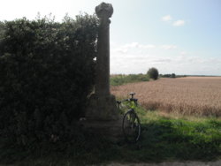
A brief stop was made, at the Memorial Cross
http://www.battlefieldstrust.com/resource-centre/warsoftheroses/battleview.asp?BattleFieldId=46
DSCF3669.JPG DSCF3667.JPG

Then onwards into Towton itself
A group (presumably, as they were being addressed as a group) were in the car-park, of the Rockingham Arms, looking like they off on the Battlefield Trail

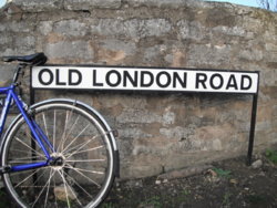
As it was, I headed down, what was the pre-TurnPike road, as evidenced by the name'

The 'TurnPike' was started in 1740, according to; http://www.tadhistory.org.uk/OLRTAP/index.html

2016 Photograph
Rides. Towton. 2.JPG


The 'OLR' was, what would at first site, be the archetypal farm/field access track, but then again, that's all it is now really
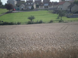
Various informative signs are around the 'Battlefield Trail', with the first one denoting the discovery of mass-graves nearby, & the strip-farming still evident in the mounds/depressions of the fields
DSCF3672.JPG


At the highest point, there was a spllt, with the Battlefield Walk, now taking a circular path, to head back towards Towton Cross, via various other important points (like the 'Bridge of Bodies')

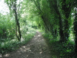
I followed the 'OLR' (or what should be it, via my memory of the OS sheet)
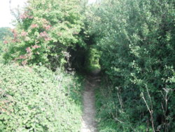
It started off, as just a gap in the hedge, with a steady descent, changing to rock-steps, as it was seemingly at the bed-rock (it is in limestone quarry territory)
http://www.geograph.org.uk/photo/1871049

I'd not call it a full blown 'Hollow-Way', but it was on the verge
The steps would have been an issue, on the 'blue' Ribble, with its '23' section tyres, but the CGR runs on '28' (Schwalbe Durano)
DSCF3674.JPG DSCF3676.JPG


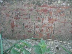
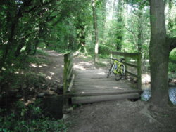
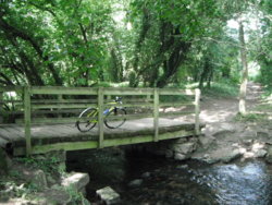
When all of a sudden, it opened up, into a little wooded area, with a bridge over the Cock Beck (the one that flowed red in March 1461)

It was so very peaceful, with barely a sound, even the wind up in the trees over the field was barely heard:okay:
The only downside was the imprint in the mud, of a MX/Enduro bike tyre:angry:
The upside was, that it was probably quiet enough to dispose of the bike, & the body, if he'd returned:angel:

DSCF3677.JPG DSCF3678.JPG

After spending a few minutes, just enjoying the silence, & probably categorising it as my 'Number 2 Peaceful Place' (after the PackHorse bridge at Dob Park, north of Otley), it was time to leave

Climbing back up the other side, was much the same, but without gravity assistance, a '23' (possibly?, on a 12-28, 10-speed cassette) was okay for the ascent
It would certainly have been a test for a team of Horses, heading northwards, that may have last been changed in Sherburn-in-Elmet (circa 8 miles), at the Red Bear
http://www.geograph.org.uk/photo/4092859

On the top, it was a rejoin of Chantry Lane, which I last saw at Towton, just after the Crooked Billet, as a bridleway/farm-road
Which then, became the modern day (ie; tarmac-ed) Old London Road
http://www.geograph.org.uk/photo/292944

Through the edge of Stutton, over the A64, with a decent into Tadcaster, where I'd not been since the Tour de Yorkshire started there (Stage 2, & the Womens race)


I had a bit of a mooch round the back-streets, & a ride along the river-bank to the weir

Back into to the town-centre, then a 'stiffening of the sinews', & a circuitous trip home

Onto the 'Tadcaster TurnPike' (A162, or is it the 'FerryBridge TurnPike' here?) I followed that, past the impressive gates into Grimston Park

A left turn onto Raw Lane, too me towards Ulleskelf, with its ever so gradual descent (1-in-30?)
Over the railway bridge, & the right fork for Church Fenton was taken, rather than the loop into Ryther & Cawood
Sadly the hedgerow at the Windmill made it all but impossible to photograph it

No such problems at Church Fenton (the old RAF airfield), as it has a shiney new sign on show
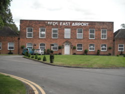
DSCF3691.JPG


Back past the Gypsum plant, & onto the Bishopdyke Road, by Sherburn station
A steady-speed ride down the Bypass, to South Milford, & the sight of another connection to days gone by, with thought of the 'London Road' sign on a (now disused, since the roundabout) branch of the 'Tadcaster TurnPike'

From here, it was a fairly routine route home
Right (west) at the roundabout with the Selby road (A63), which is even referred to as 'TurnPike' on the milestones
2009 Photograph
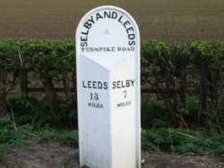
North Yorkshire Scenes. South Milford. Milestone. 1.JPG

A left, onto Rawfield Lane, to head back towards Fairburn, & another meeting with the 'Great North Road', as I passed over, first the 'new' A1, then the now downgraded 'old' A1, & finally a couple of hundred yards on the 'GNR' (right in front of the houses & village School

Home, via Newton Lane, past the RSPB centre, meeting Barnsdale Road again, at Allerton Crossroads, & home in the reverse order of the start of this elongated tale

I hope it entertained/informed/enlightened at least one person
If so, it was worthwhile writing it:becool:


Circa ; 40 miles, & the route is here; https://gb.mapometer.com/cycling/route_4599151.html
 
Last edited:
Top Bottom