Richard A Thackeray
Legendary Member
Bike selected; CGR (wet roads, a lot of detritus on the quieter lanes, still mucky, near Micklefield Land-Fill)
Weather; overcast. reasonably mild, strong west wind on return
Photographs from today (unless captioned otherwise)
Just a local-ish loop
Out towards Castleford, under the M62 (jct 31) past the Voysey Row
That H&S mans nightmare is also on this road; 'Digger-Land'
Up the hill, to the site of the old Mining College, which was a gorgeous building
(knocked down, now covered in 'box-like' houses, & a replacement College built about a mile away, near 'Xscape')
http://www.geograph.org.uk/photo/1048161
http://www.geograph.org.uk/photo/1048153
http://www.geograph.org.uk/photo/1048167
Into Hightown, & past the site of Castleford & Normanton District Hospital (also flattened, or due to be!!)
Over the level-crossing on Albion Street, past the bus station
Down to the site of the Roman Fort, & the crossing point of the River Aire
(if Barnsdale Road - a Roman road, was continued, in a straight line, from its departure from the A1, at Barnsdale Bar..... between Doncaster & FerryBridge, it'd cross here)
No date, as iPhone picture, but pre-2017
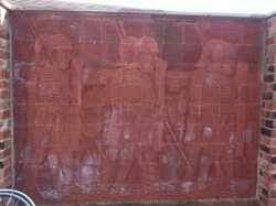
Along, a very wet Barnsdale Road, interspersed with standing water at the sides, but thankfully nowhere near enough rain, further up the River Aire, to pose the slightest problems
Up 'Mary Pannal hill' once more, and up to Peckfield Bar, which is (as previously noted) where the A63 (Leeds - Selby turnpike) crosses the Barnsdale Road
Once over the Leeds - York railway line, it was a careful manoeuvre onto the white line, for a right turn onto Church Lane, towards Micklefield
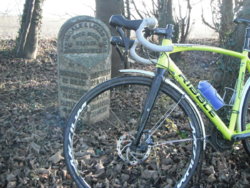
Having just passed this partially hidden milestone
Barnsdale & Leeds Road
HookMoor Branch
In Micklefield, reminders of the villages previous history, as a stop on, what was quite possibly the most important road in the Country
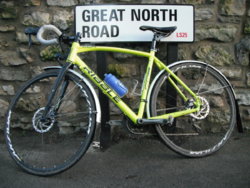
Yes, like many other towns & villages, the pre dual-carriagewayed A1 went through here
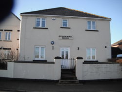
With a Memorial School to a local Blacksmith
(excuse the finger)
http://www.geograph.org.uk/photo/4919912
http://www.aboutmicklefield.btck.co.uk/MethodistChapel
http://www.aboutmicklefield.btck.co.uk/SammyHick
I passed southbound, along the GNR route, until reaching the 'Boot & Shoe junction, which was where the A63 (from Garforth & Leeds joined)
Nowadays, the A63 joins via a roundabout, with the GNR as a 'local road' to Micklefield
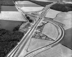
I'm not old enough to remember it as a road junction, but certainly remember the flyover, for eastbound/southbound traffic to join the A1
The mounds are still there
How it was....................
A63/Leeds to the top-left
Micklefield top-centre
NOT MY IMAGE
Straight down this. now almost deadly quiet road, to 'Selby Fork' as it's still known
(the old A63, Selby road, remains as a service road for the Hotel there
Seen as a white-road, at the roundabout, with the Ledsham road (TOP OF MAP)
Even that junction has changed, but traces of the roundabout are still there, under grassed areas!
Undated, but a 1986 sheet
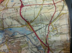
Looking at the map, the old (now demolished) bridge at Fairburn can also be seen, that's now a roundabout
Friday 3rd June 2016
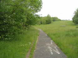
After the junction with the A63/'new' A1 feeder, it a short trip down the 'old' A1 (now single-carriagwayed)
I came from the same direction as the van
http://www.geograph.org.uk/photo/1996868
Into Fairburn past the village 'lock-up' (in a limestone outcrop)
http://www.geograph.org.uk/photo/2695319
Drop down towards the Ings, & past the RSPB centre, near the junction of Back Newton Lane (towards the top of 'Mary Pannall', & Newton Lane
A short ride into Castleford, & a continuation of the headwind, back home
The M62 junction was horrendous, with it acting as a wind tunnel
Just in front of me. was another rider, in old Garmin strip (jacket & bib-tights)
At first I thought he was on a Bianchi, as it seemed to be Celeste coloured
It was a TOMAC
I did put it him, that he must have been a MTBer to have such a (named) frame
No, he'd never ridden MTB & didn't know the name
For such a short ride, I was glad to be home, given the rather gusty wind
Roll on 2018
PS;
Apologies, for rambling on
But, I hope that at least one of you has found a piece of information enclosed, that you didn't know before, & that thus I have increased your knowledge
Weather; overcast. reasonably mild, strong west wind on return
Photographs from today (unless captioned otherwise)
Just a local-ish loop
Out towards Castleford, under the M62 (jct 31) past the Voysey Row
That H&S mans nightmare is also on this road; 'Digger-Land'
Up the hill, to the site of the old Mining College, which was a gorgeous building
(knocked down, now covered in 'box-like' houses, & a replacement College built about a mile away, near 'Xscape')
http://www.geograph.org.uk/photo/1048161
http://www.geograph.org.uk/photo/1048153
http://www.geograph.org.uk/photo/1048167
Into Hightown, & past the site of Castleford & Normanton District Hospital (also flattened, or due to be!!)
Over the level-crossing on Albion Street, past the bus station
Down to the site of the Roman Fort, & the crossing point of the River Aire
(if Barnsdale Road - a Roman road, was continued, in a straight line, from its departure from the A1, at Barnsdale Bar..... between Doncaster & FerryBridge, it'd cross here)
No date, as iPhone picture, but pre-2017

Along, a very wet Barnsdale Road, interspersed with standing water at the sides, but thankfully nowhere near enough rain, further up the River Aire, to pose the slightest problems
Up 'Mary Pannal hill' once more, and up to Peckfield Bar, which is (as previously noted) where the A63 (Leeds - Selby turnpike) crosses the Barnsdale Road
Once over the Leeds - York railway line, it was a careful manoeuvre onto the white line, for a right turn onto Church Lane, towards Micklefield
Having just passed this partially hidden milestone
Barnsdale & Leeds Road
HookMoor Branch

In Micklefield, reminders of the villages previous history, as a stop on, what was quite possibly the most important road in the Country

Yes, like many other towns & villages, the pre dual-carriagewayed A1 went through here
With a Memorial School to a local Blacksmith
(excuse the finger)
http://www.geograph.org.uk/photo/4919912
http://www.aboutmicklefield.btck.co.uk/MethodistChapel
http://www.aboutmicklefield.btck.co.uk/SammyHick

I passed southbound, along the GNR route, until reaching the 'Boot & Shoe junction, which was where the A63 (from Garforth & Leeds joined)
Nowadays, the A63 joins via a roundabout, with the GNR as a 'local road' to Micklefield
I'm not old enough to remember it as a road junction, but certainly remember the flyover, for eastbound/southbound traffic to join the A1
The mounds are still there
How it was....................
A63/Leeds to the top-left
Micklefield top-centre
NOT MY IMAGE

Straight down this. now almost deadly quiet road, to 'Selby Fork' as it's still known
(the old A63, Selby road, remains as a service road for the Hotel there
Seen as a white-road, at the roundabout, with the Ledsham road (TOP OF MAP)
Even that junction has changed, but traces of the roundabout are still there, under grassed areas!
Undated, but a 1986 sheet

Looking at the map, the old (now demolished) bridge at Fairburn can also be seen, that's now a roundabout
Friday 3rd June 2016

After the junction with the A63/'new' A1 feeder, it a short trip down the 'old' A1 (now single-carriagwayed)
I came from the same direction as the van
http://www.geograph.org.uk/photo/1996868
Into Fairburn past the village 'lock-up' (in a limestone outcrop)
http://www.geograph.org.uk/photo/2695319
Drop down towards the Ings, & past the RSPB centre, near the junction of Back Newton Lane (towards the top of 'Mary Pannall', & Newton Lane
A short ride into Castleford, & a continuation of the headwind, back home
The M62 junction was horrendous, with it acting as a wind tunnel
Just in front of me. was another rider, in old Garmin strip (jacket & bib-tights)
At first I thought he was on a Bianchi, as it seemed to be Celeste coloured
It was a TOMAC
I did put it him, that he must have been a MTBer to have such a (named) frame
No, he'd never ridden MTB & didn't know the name

For such a short ride, I was glad to be home, given the rather gusty wind
Roll on 2018
PS;
Apologies, for rambling on
But, I hope that at least one of you has found a piece of information enclosed, that you didn't know before, & that thus I have increased your knowledge

Attachments
Last edited:


 and a little ice cream


