Your ride today.... (part 1)

Status
Not open for further replies.
Page may contain affiliate links. Please see terms for details.

Spartak

Powered by M&M's
Location
Bristolian
Took a longer route home from work today passing through the village of Pill to join the River Avon cycle path.
Then climbed the steep wooded section through Leigh Woods http://www.strava.com/segments/5189639?filter=overall to have a brief spin round part of the Yer Tiz MTB trail, then across the Clifton Suspension Bridge, down the 1:6 Constitution Hill & across Millennium Square where deckchairs were set up for people to watch the tennis on @Bristol's big screen.
Crossed Peros Bridge and joined up with the Old railway path for the gradual climb out of town.

http://www.strava.com/activities/161556442

First picture taken on the Ashton-Pill track. Second is of Bristol Harbourside.
2014-07-04 11.51.41.jpg

2014-07-04 12.25.18.jpg
 

Saluki

World class procrastinator
sadly I can't tell you if it is a mouse or not because it says I don't have sufficient privileges :sad:
Heigh ho. I don't know how to copy it on to here. It looks more like a mouse if you've had a drink or two and you squint a bit.
 

Donger

Convoi Exceptionnel
Location
Quedgeley, Glos.
Operation Outrageous, 4/7/2014:

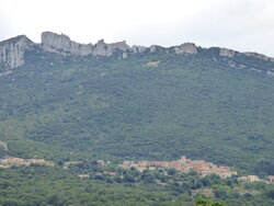
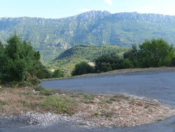
I promised you something a bit outrageous today, so here goes. The other day, we took a drive up to the ruined Cathar fortress of Peyrepertuse, which stands at the top of a huge imposing limestone bluff, and was built to be totally inaccessible to religious persecutors during the medieval wars of religion. Someone has since come along and built a totally stunning, winding tourist road up from the village of Duilhac- sous-Peyrepertuse to a car park just at the bottom of the cliff and within a stone's throw of the fortress (if you are Geoff Capes).

Not being one to shirk a challenge, I took one look at all the steep bits and the hairpin bends and decided I just had to have a go at it on the bike. Yes, I'm 53 years old. Yes, I weigh over 20 stone (280 pounds). Yes, I have an ingrowing toenail in my left big toe, and I injured my right big toe earlier today. That just balances things up. Yes, Mrs Donger did say "You'll never make it up here!". To be honest, that sealed it. Today was the last day of our second (and probably last) holiday here, so it was probably the last chance I would ever get to try it. So game on, then.
149 Duilhac sous Peyrepertuse.JPG
Photo 1. Duilhac at the bottom, Peyrepertuse at the top.

As I drove to Duilhac to start my ride from there, my finishing point was, as the crow flies, just about the same as my starting point, being almost vertically above it. Nevertheless, it would be a 5.5 mile ride if I managed it.. 2.75 up and 2.75 back down. Easily my shortest, but by far my toughest ride of the year so far. There had been thunder earlier in the day, and it was still very windy at the cottage, but when I drove over the hill to Duilhac, a miraculous weather window opened up, and clear blue skies and strong sunshine took over. The omens were good. Inspired by the thought that this was a once-in-a-lifetime opportunity to climb this road, I set off full of determination and made good progress at first.

161 Parachute landing ground.jpg
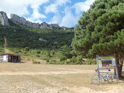
Photo 2. The parachute landing ground @ 1.5 miles along the climb (my first stop).

I overdid it a bit at the bottom, and should have stopped for a drink before I actually did. I made it to a small flat spot in he climb at the 1.5 mile mark, where there was a parachute landing ground. The info board showed that there were still 150 more metres of climbing to be done, and by my reckoning, there were about 1.5 km to go, making an average gradient form her onwards of 10%. This was discouraging, to say the least, and it was from this point onwards that my troubles began..

162 On climb to Peyrepertuse.jpg 163.jpg 164.jpg
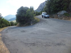
Photos 3, 4 and 5


After 3 or 4 of the steeply banked hairpin bends, I hit a longish straight. The trouble was, it was heading straight into a strong headwind. I was sweating profusely by this point, and using up my drink at an alarming rate. Several distressingly steep gradient changes (15% or more) left me feeling like I was facing my local nemesis, Haresfield Beacon, and if I hadn't mouthed off about doing this ride today I may well have given up at any one of a number of points. Trying to summon up some of the spirit that once made Britain great, I plugged on. After not stopping at all in the first 1.5 miles, I must have stopped at least 6 or 7 times in the next mile.

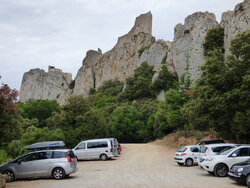
As I was at my lowest point, both physically and morale-wise, a car full of Belgians pulled up alongside and took a close-up photo, just as I was gagging to throw in the towel. They then slipped in behind me and followed me for a minute or so. B@stards! (I now understand exactly why Cadel Evans sometimes looks like he wants to rip the head off anyone who so much as touches him or looks at him funnily on a big climb). Once they had cleared off, I got off and leaned against a wall, panting, for about 5 minutes, before taking my emergency energy gell from the saddle bag. I went off again too soon, and only managed about 100 yards more before my next palpitation break. With a touch of cruelty, someone had decided to signal the upcoming car park with a couple of striped poles - placed just before what seemed to be the steepest part of the whole climb, and with a further hairpin still to be negotiated. I stopped again. Summoning up every ounce of energy I had left, I just gritted my teeth and went for it - aware that I was no longer puffing like a steam locomotive, but instead now grunting louder than Maria Sharapova on Centre Court. Then I got my first sight of the car park at the top, and I got a new lease of life. There was no stopping me now.

128.JPG
Photo 6. The car park, at last.

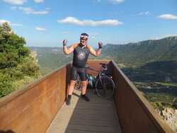
Against all the remaining expectations I had by the half way point, I had actually done it! A friendly Swedish guy kindly took my picture for me, on the skywalk viewpoint or "belvedere". Please excuse my smugness If I look rather too pleased with myself in photo 7.

165.jpg
Photo 7

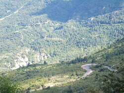
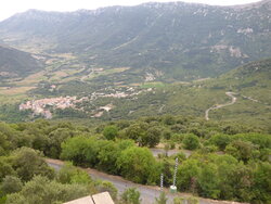
From the belvedere i got this great shot, showing the road winding away below me:


130 Winding road up to the castle.JPG
Photo 8.

The way back down was far from straightforward, as some of the hairpins were way too steep (both angle-wise and gradient-wise) for comfort, and my brakes were squeaing alarmingly at every turn. I actually got off an walked a couple of times, as my wheel rims were so hot that I thought my front tyre might be about to explode. When I reached the bottom, everybody was turning to see where that awful squealing noise was coming from. Not sure if that was the brakes or me. Total relief to make it back down, but mostly just felt fantastic. This kind of ride is what I took up cycling for, 6 years ago.

Now I know some of you youngsters might not regard a 2.75 mile climb as that special, but for me, this was my Alpe d'Huez.. Officially the height at the top was 650 metres, and from the map, it looks as though it is about 250 metres. By my calculations, over about 4.4 km, that makes it an average gradient of 9%. Although a bit on the short side, that would put it at borderline cat 1/cat 2 Tour de France rating. I am now going to consider myself a cyclist.

That's it for these hols. Cheers everyone. Donger.
 

gavgav

Legendary Member
Operation Outrageous, 4/7/2014:

I promised you something a bit outrageous today, so here goes. The other day, we took a drive up to the ruined Cathar fortress of Peyrepertuse, which stands at the top of a huge imposing limestone bluff, and was built to be totally inaccessible to religious persecutors during the medieval wars of religion. Someone has since come along and built a totally stunning, winding tourist road up from the village of Duilhac- sous-Peyrepertuse to a car park just at the bottom of the cliff and within a stone's throw of the fortress (if you are Geoff Capes).

Not being one to shirk a challenge, I took one look at all the steep bits and the hairpin bends and decided I just had to have a go at it on the bike. Yes, I'm 53 years old. Yes, I weigh over 20 stone (280 pounds). Yes, I have an ingrowing toenail in my left big toe, and I injured my right big toe earlier today. That just balances things up. Yes, Mrs Donger did say "You'll never make it up here!". To be honest, that sealed it. Today was the last day of our second (and probably last) holiday here, so it was probably the last chance I would ever get to try it. So game on, then.
View attachment 49448
Photo 1. Duilhac at the bottom, Peyrepertuse at the top.

As I drove to Duilhac to start my ride from there, my finishing point was, as the crow flies, just about the same as my starting point, being almost vertically above it. Nevertheless, it would be a 5.5 mile ride if I managed it.. 2.75 up and 2.75 back down. Easily my shortest, but by far my toughest ride of the year so far. There had been thunder earlier in the day, and it was still very windy at the cottage, but when I drove over the hill to Duilhac, a miraculous weather window opened up, and clear blue skies and strong sunshine took over. The omens were good. Inspired by the thought that this was a once-in-a-lifetime opportunity to climb this road, I set off full of determination and made good progress at first.

View attachment 49449
Photo 2. The parachute landing ground @ 1.5 miles along the climb (my first stop).

I overdid it a bit at the bottom, and should have stopped for a drink before I actually did. I made it to a small flat spot in he climb at the 1.5 mile mark, where there was a parachute landing ground. The info board showed that there were still 150 more metres of climbing to be done, and by my reckoning, there were about 1.5 km to go, making an average gradient form her onwards of 10%. This was discouraging, to say the least, and it was from this point onwards that my troubles began..

View attachment 49450 View attachment 49451 View attachment 49452
Photos 3, 4 and 5


After 3 or 4 of the steeply banked hairpin bends, I hit a longish straight. The trouble was, it was heading straight into a strong headwind. I was sweating profusely by this point, and using up my drink at an alarming rate. Several distressingly steep gradient changes (15% or more) left me feeling like I was facing my local nemesis, Haresfield Beacon, and if I hadn't mouthed off about doing this ride today I may well have given up at any one of a number of points. Trying to summon up some of the spirit that once made Britain great, I plugged on. After not stopping at all in the first 1.5 miles, I must have stopped at least 6 or 7 times in the next mile.

As I was at my lowest point, both physically and morale-wise, a car full of Belgians pulled up alongside and took a close-up photo, just as I was gagging to throw in the towel. They then slipped in behind me and followed me for a minute or so. B@stards! (I now understand exactly why Cadel Evans sometimes looks like he wants to rip the head off anyone who so much as touches him or looks at him funnily on a big climb). Once they had cleared off, I got off and leaned against a wall, panting, for about 5 minutes, before taking my emergency energy gell from the saddle bag. I went off again too soon, and only managed about 100 yards more before my next palpitation break. With a touch of cruelty, someone had decided to signal the upcoming car park with a couple of striped poles - placed just before what seemed to be the steepest part of the whole climb, and with a further hairpin still to be negotiated. I stopped again. Summoning up every ounce of energy I had left, I just gritted my teeth and went for it - aware that I was no longer puffing like a steam locomotive, but instead now grunting louder than Maria Sharapova on Centre Court. Then I got my first sight of the car park at the top, and I got a new lease of life. There was no stopping me now.

View attachment 49453
Photo 6. The car park, at last.

Against all the remaining expectations I had by the half way point, I had actually done it! A friendly Swedish guy kindly took my picture for me, on the skywalk viewpoint or "belvedere". Please excuse my smugness If I look rather too pleased with myself in photo 7.

View attachment 49454
Photo 7

From the belvedere i got this great shot, showing the road winding away below me:


View attachment 49455
Photo 8.

The way back down was far from straightforward, as some of the hairpins were way too steep (both angle-wise and gradient-wise) for comfort, and my brakes were squeaing alarmingly at every turn. I actually got off an walked a couple of times, as my wheel rims were so hot that I thought my front tyre might be about to explode. When I reached the bottom, everybody was turning to see where that awful squealing noise was coming from. Not sure if that was the brakes or me. Total relief to make it back down, but mostly just felt fantastic. This kind of ride is what I took up cycling for, 6 years ago.

Now I know some of you youngsters might not regard a 2.75 mile climb as that special, but for me, this was my Alpe d'Huez.. Officially the height at the top was 650 metres, and from the map, it looks as though it is about 250 metres. By my calculations, over about 4.4 km, that makes it an average gradient of 9%. Although a bit on the short side, that would put it at borderline cat 1/cat 2 Tour de France rating. I am now going to consider myself a cyclist.

That's it for these hols. Cheers everyone. Donger.
:thumbsup: Good man @Donger !!
 

coffeejo

Ælfrēd
Location
West Somerset
Operation Outrageous, 4/7/2014:

I promised you something a bit outrageous today, so here goes. The other day, we took a drive up to the ruined Cathar fortress of Peyrepertuse, which stands at the top of a huge imposing limestone bluff, and was built to be totally inaccessible to religious persecutors during the medieval wars of religion. Someone has since come along and built a totally stunning, winding tourist road up from the village of Duilhac- sous-Peyrepertuse to a car park just at the bottom of the cliff and within a stone's throw of the fortress (if you are Geoff Capes).

Not being one to shirk a challenge, I took one look at all the steep bits and the hairpin bends and decided I just had to have a go at it on the bike. Yes, I'm 53 years old. Yes, I weigh over 20 stone (280 pounds). Yes, I have an ingrowing toenail in my left big toe, and I injured my right big toe earlier today. That just balances things up. Yes, Mrs Donger did say "You'll never make it up here!". To be honest, that sealed it. Today was the last day of our second (and probably last) holiday here, so it was probably the last chance I would ever get to try it. So game on, then.
View attachment 49448
Photo 1. Duilhac at the bottom, Peyrepertuse at the top.

As I drove to Duilhac to start my ride from there, my finishing point was, as the crow flies, just about the same as my starting point, being almost vertically above it. Nevertheless, it would be a 5.5 mile ride if I managed it.. 2.75 up and 2.75 back down. Easily my shortest, but by far my toughest ride of the year so far. There had been thunder earlier in the day, and it was still very windy at the cottage, but when I drove over the hill to Duilhac, a miraculous weather window opened up, and clear blue skies and strong sunshine took over. The omens were good. Inspired by the thought that this was a once-in-a-lifetime opportunity to climb this road, I set off full of determination and made good progress at first.

View attachment 49449
Photo 2. The parachute landing ground @ 1.5 miles along the climb (my first stop).

I overdid it a bit at the bottom, and should have stopped for a drink before I actually did. I made it to a small flat spot in he climb at the 1.5 mile mark, where there was a parachute landing ground. The info board showed that there were still 150 more metres of climbing to be done, and by my reckoning, there were about 1.5 km to go, making an average gradient form her onwards of 10%. This was discouraging, to say the least, and it was from this point onwards that my troubles began..

View attachment 49450 View attachment 49451 View attachment 49452
Photos 3, 4 and 5


After 3 or 4 of the steeply banked hairpin bends, I hit a longish straight. The trouble was, it was heading straight into a strong headwind. I was sweating profusely by this point, and using up my drink at an alarming rate. Several distressingly steep gradient changes (15% or more) left me feeling like I was facing my local nemesis, Haresfield Beacon, and if I hadn't mouthed off about doing this ride today I may well have given up at any one of a number of points. Trying to summon up some of the spirit that once made Britain great, I plugged on. After not stopping at all in the first 1.5 miles, I must have stopped at least 6 or 7 times in the next mile.

As I was at my lowest point, both physically and morale-wise, a car full of Belgians pulled up alongside and took a close-up photo, just as I was gagging to throw in the towel. They then slipped in behind me and followed me for a minute or so. B@stards! (I now understand exactly why Cadel Evans sometimes looks like he wants to rip the head off anyone who so much as touches him or looks at him funnily on a big climb). Once they had cleared off, I got off and leaned against a wall, panting, for about 5 minutes, before taking my emergency energy gell from the saddle bag. I went off again too soon, and only managed about 100 yards more before my next palpitation break. With a touch of cruelty, someone had decided to signal the upcoming car park with a couple of striped poles - placed just before what seemed to be the steepest part of the whole climb, and with a further hairpin still to be negotiated. I stopped again. Summoning up every ounce of energy I had left, I just gritted my teeth and went for it - aware that I was no longer puffing like a steam locomotive, but instead now grunting louder than Maria Sharapova on Centre Court. Then I got my first sight of the car park at the top, and I got a new lease of life. There was no stopping me now.

View attachment 49453
Photo 6. The car park, at last.

Against all the remaining expectations I had by the half way point, I had actually done it! A friendly Swedish guy kindly took my picture for me, on the skywalk viewpoint or "belvedere". Please excuse my smugness If I look rather too pleased with myself in photo 7.

View attachment 49454
Photo 7

From the belvedere i got this great shot, showing the road winding away below me:


View attachment 49455
Photo 8.

The way back down was far from straightforward, as some of the hairpins were way too steep (both angle-wise and gradient-wise) for comfort, and my brakes were squeaing alarmingly at every turn. I actually got off an walked a couple of times, as my wheel rims were so hot that I thought my front tyre might be about to explode. When I reached the bottom, everybody was turning to see where that awful squealing noise was coming from. Not sure if that was the brakes or me. Total relief to make it back down, but mostly just felt fantastic. This kind of ride is what I took up cycling for, 6 years ago.

Now I know some of you youngsters might not regard a 2.75 mile climb as that special, but for me, this was my Alpe d'Huez.. Officially the height at the top was 650 metres, and from the map, it looks as though it is about 250 metres. By my calculations, over about 4.4 km, that makes it an average gradient of 9%. Although a bit on the short side, that would put it at borderline cat 1/cat 2 Tour de France rating. I am now going to consider myself a cyclist.

That's it for these hols. Cheers everyone. Donger.
Made for a great read. Chapeau! Hope the legs aren't too sore today.
 

Donger

Convoi Exceptionnel
Location
Quedgeley, Glos.
Made for a great read. Chapeau! Hope the legs aren't too sore today.
Thanks Jo. Actually my legs feel like they are made out of elastic today, and I'm feeling great. This usually happens to me straight after a tough one - it's the day after the day after that normally gets me! Gonna have to get down to the LBS in a hurry though, to get my brakes sorted and a new rear tyre before Londo-Brighton next weekend.
 

BigonaBianchi

Yes I can, Yes I am, Yes I did...Repeat.
 

beardy01

Well-Known Member
Location
edenbridge
Unlike a lot of you on strava i use map my ride ( just works better in my area ). They are doing a tdf challenge to ride every day theres a stage of the tdf with prizes for various achievements and miles completed, the main one being first 150 riders to complete 500 miles. With that carrot dangled just done 31 miles ( would have been longer but promised the missus lunch last week before i got the email..... it was a tough decision!!!!!! ) averaged 16.5 mph and that was into 13mph headwinds, happy with my ride and dodged the rain.....can now enjoy that 20 ounce t bone. 19th out of 28000 at the moment that free jersey is in my grip but a long way to go yet. Allez cav!!!!!!
 

Spartak

Powered by M&M's
Location
Bristolian
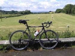
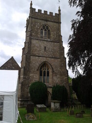
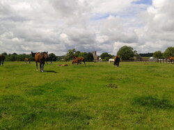
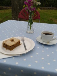
After watching the early rain clear away. I got out on the bike at 11:30, headed east up to Dodington, before crossing the A46 and the rolling countryside which took me through the South Cotswold villages of West Kington, Nettleton, The Gibb, Grittleton, Luckington & Horton, where I spotted a sign for Teas & cakes at the Church Flower Festival so a quick right turn led to a pleasant refreshment stop. It was then mainly downhill for the ride back to Bristol although a nagging headwind slowed my return.
Great couple of hours on the bike - now have feet up watching Le Tour :thumbsup:

http://www.strava.com/activities/161946433

2014-07-05 11.58.24.jpg 2014-07-05 13.17.07.jpg

2014-07-05 12.15.03.jpg 2014-07-05 13.21.00.jpg
 

ScotiaLass

Guru
Location
Middle Earth
Probably the hardest post I've had to make, but here goes......

My mum passed away on Saturday morning, after her brave battle with cancer. I decided to pull out of the BHF Worcester Ride, on Sunday, as it would have been dangerous for me to attempt it in the state I was in.

After a tough few days of sorting things out, I did a short but much needed ride today, for a bit of thinking time and to clear the head.

I headed out to Upton Magna, Withington, Rodington, Roden, Poynton, Bings Heath and back to Upton Magna, retracing my steps home.

It was lovely and warm, but quite breezy by the end of the ride.

23 miles at 12.5 mph avg

I plan to arrange a 50 mile route with @Rickshaw Phil as my own BHF ride, sometime over the coming few weeks, when things like funeral are out of the way. That way I will feel happy that I achieved something for all of the sponsorship that I have collected (£495)

I would like to thank people on here for their support and kind messages about mum over the past 6 months.

Cycling is going to be very high up on the list of things that will get me through this
I am so sorry to hear your news. I can't add anything else, except to say that I am thinking of you and you WILL get through this in time.
Cycling has helped my depression, which started after I lost my mum to Pancreatic cancer 13 years ago.
Stay strong!
 

ScotiaLass

Guru
Location
Middle Earth
A quick 10 miles today - I wanted to do longer but didn't have the time, still it was better than not going out at all!
The usual route, nothing exciting to say about it except the Kelpies were heaving today!!
There was a blustery headwind but funnily enough it didn't bother me as much as usual.

When I started cycling last year, I used to climb that cemetery hill in 1st gear (out of the 27 available to me!). Today I climbed it in 12th.
I'm happy that I am gradually seeing an improvement in my fitness and the weight loss is continuing.
:bravo:
 

BrynCP

Über Member
Location
Hull
40 miles today with a bit of a climb near the end: managed that in two goes this time, instead of the three last time. Hopefully one next time!

However, pedestrians nearly had me off early on the in ride. I am riding at about 20mph and out steps a group of adults. So I brake as I approach them, one of the women instead of hurrying up crossing the road, instead stops (in my path) and starts clapping saying something like "well done" and something about Tour De France, 4x4 to my right so nowhere for me to go other than hope I can unclip and finish braking in time. She did move at the last minute, but then I was such a high gear to be able to move off smoothly.

Get to the a crossing about 200m down the road, and another load of pedestrians ignoring the "red man" and also walk out in my path.
 

welsh dragon

Thanks but no thanks. I think I'll pass.
I bet you lot are sick and tired of me just showing you photos of trees, grass, sheep, cows and water, so today I thought I would kill two birds with one stone. Ill be showing you my local town. I wanted to experiment with my saddle as it was too low, so I could ride around the car park raising the saddle to test it. It still needs a bit of a tweak, but as @Rickshaw Phil always says, the first thing to do is check the height of your saddle if your having problems.

Owain Glandwr was the last Welsh prince of Wales, and he had Machynlleth (Mach) as the locals call it as his capital. The Welsh parliament was held here and this building was built around 1404
20140705_114145.jpg


20140705_114117.jpg


there are only around 2,000 people in Mach, but even so we still have a park.
20140705_112956.jpg


very fancy gates leading into the park.

20140705_113236.jpg


there's even a nice small woodland for the kids to play in
20140705_113525.jpg
20140705_113505.jpg


at the end of the main road is a crossroads. The town clock is there. A couple of years ago, the town spent a lot of money repairing and cleaning it. If you turn left at the clock, the road takes you to Aberystwyth which is about 18 miles away from Mach. If you go right at the clock, the road takes you to CAT, the centre for alternative technology which was set up in the 70's
20140705_114834.jpg
 
Status
Not open for further replies.
Top Bottom