Richard A Thackeray
Legendary Member
Friday 13th
9.
Old Great North Road (now the A162)
Brotherton
Just north of Sutton Road, that heads across to Birkin, & its eponymous Cafe

https://britishlistedbuildings.co.u...-with-byram-park-road-brotherton#.Yn6G1YzMLIU
https://www.geograph.org.uk/photo/6049113
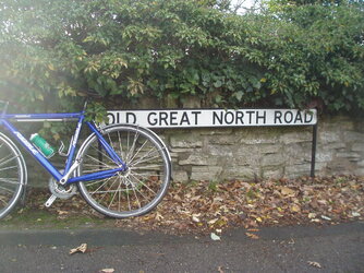
And, just a few dozen yards north of this, the old name remains
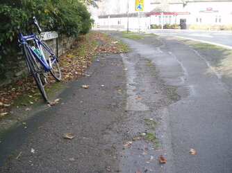
The old kerbstone are there too, that marked the edge of the 'GNR', as it turned slightly north-west into Brotherton, but absorbed into the pavement now
They're where the signs are to the left of the road
https://www.geograph.org.uk/photo/553592
(both were taken 20/11/2015)


9.
Old Great North Road (now the A162)
Brotherton
Just north of Sutton Road, that heads across to Birkin, & its eponymous Cafe
https://britishlistedbuildings.co.u...-with-byram-park-road-brotherton#.Yn6G1YzMLIU
https://www.geograph.org.uk/photo/6049113
And, just a few dozen yards north of this, the old name remains
The old kerbstone are there too, that marked the edge of the 'GNR', as it turned slightly north-west into Brotherton, but absorbed into the pavement now
They're where the signs are to the left of the road
https://www.geograph.org.uk/photo/553592
(both were taken 20/11/2015)


Last edited:


