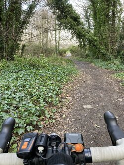
The CC Trig Point bagger thread, now incorporating other interesting geographs

Page may contain affiliate links. Please see terms for details.
Monday 7th
9.


Leeds House
(opposite 'Commerce House')
WheelGate
Malton

Yes, that's my travel-stained Kodiaq in the picture


630120


https://www.geograph.org.uk/photo/3256973
 
Last edited:
Monday 7th
10.

Castle Howard Railway Station
Castle Howard Station Road
(off the A64)
Just east of Whitwell-on-the-Hill

630121


630122


https://britishlistedbuildings.co.u...use-and-platform-cottage-welburn#.YgF1H5bP3IU
https://www.geograph.org.uk/photo/3147558
http://www.disused-stations.org.uk/c/castle_howard/index.shtml
'Holiday apartment' available; https://castlehowardstation.com/
 
Last edited:
Wednesday 9th
1.

Kings Road Bridge
Aire & Calder Navigation Canal
(bottom of) Foxholes Lane
Altofts

The dark rectangle in the distance is a truck on the M62, travelling west (between jcts 31 & 30)
630411


https://www.geograph.org.uk/photo/4157654

Hidden from view, but approximately where the red barge is, there's a filled in/'stopped' lock that allowed cross-traffic with the River Calder
It's a heck of a difference, maybe 25 feet, at normal water levels!

The M62 bridge, can be seen in the background
This is where the truck came off, a few months ago
https://www.geograph.org.uk/photo/3278080
https://www.geograph.org.uk/photo/6717586

The Lock into the River, can be seen on this 1905 OS; https://maps.nls.uk/geo/explore/#zoom=17&lat=53.71685&lon=-1.43361&layers=168&b=1
 
Last edited:
Last edited:
Wednesday 9th
3.

NewLands Hall Stable-Block
NewLands Woods
NewLands Lane
Altofts-cum-NewLands

630415


https://britishlistedbuildings.co.u...hall-newland-with-woodhouse-moor#.YgUvSpbP3IU
https://stanleyhistoryonline.com/newland-estate
https://www.geograph.org.uk/photo/2416200

The approach to it, & most of the way through NewLands Woods was fine, with just a few greasy sections, on the approach from 'Stanley Ferry'
The Stables are to my left, just after the precariously leaning tree
630416

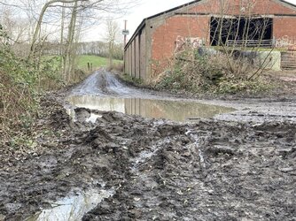
And as for the exit from the Woods.........................
A lot of farm traffic has chewed it up, & there's a bit of 'run-off..............
I rode through just where a tyre-track is descernible, by the drinks can

Yes!, my feet stayed dry:okay:

630417
 
Last edited:
Friday 11th
2.

Methley South Station
Now a private house & restored
Accessed off Barnsdale Road/A639

Built for the Methley Joint Railway, otherwise known as the ‘Lancashire & Yorkshire, Great Northern and North Eastern Railway’

630509


630512


September 1958
Note the brick building closest to the camera, on the left, still remains in use to this day
630514


630513


Taken from one of my books
630515


http://lostrailwayswestyorkshire.co.uk/Lofthouse Outwood.htm#Methley South Joint Station L&Y GNR NER
https://www.geograph.org.uk/photo/3467423
The buildings can be seen over the bridge; https://www.geograph.org.uk/photo/3467423


From another book
The ‘Closure’ notice is up
C7CCEDC9-9D36-47D2-A2EA-4B91DD00ED2D.jpeg


27F216F1-D43A-451D-AD49-744D55247516.jpeg
 
Last edited:
Friday 11th
3.

Further along the ‘Castleford Greenway’
Which leads to Bottomboat, along the trackbed of the old Methley Joint Railway, officially known as the ‘Lancashire & Yorkshire, Great Northern and North Eastern Railway’

630524


WaterGate/Newmarket Lane can be seen behind (white house)
630525


https://www.geograph.org.uk/photo/2014321
https://www.cyclecityconnect.co.uk/our-routes/castleford-to-wakefield-greenway/
https://www.sustrans.org.uk/our-blo...-of-the-castleford-greenway-officially-opens/
 
Last edited:
We're going away for an over-night stay 'next weekend'
Suggestions included; Leicester, Whitby, Morecambe

I'll still feel like I'm performing missionary work, as we're heading over the frontier, into the Lancastrian wastelands
It was via a nicely circuitous route:okay:
Apologies, there's not as many photographs as I wanted, because location/weather/time didn't really allow for them

Saturday 12th
1.

KirkGate
Otley

I’d have thought it’s a reasonably wealthy town, so could afford more?

1845FB43-4AB4-40CF-A4BA-6B1588CB15B0.jpeg


It's not far from the pelican crossing, & on the right, as we look at the photograph; https://www.geograph.org.uk/photo/6660540
 
Last edited:
Top Bottom