The CC Trig Point bagger thread, now incorporating other interesting geographs

Page may contain affiliate links. Please see terms for details.
Thursday 11th
1.


Toll-Office/'Packet Office'
Confluence of the Rivers Aire & Calder
(off) Barnsdale Road/A656
Castleford

573391


https://www.geograph.org.uk/photo/5655656
https://www.geograph.org.uk/photo/684959


@Drago
Edit @ 20:26
Goods/passengers would be gathered here, for the trip along the River, or Canal
In fact, not too far away, on the River Aire, there is a surviving set of steps that gave access to a regular boat service to Goole!!
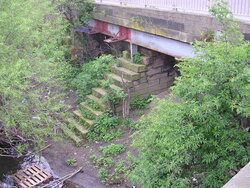
Castleford. Bridge 3.JPG
https://www.geograph.org.uk/photo/649841
 
Last edited:
Thursday 11th
2.


Not a structural feature, or marking an event/memorial
But, this is a semi-regular occurance (3 times already this year, I think?)


Flood plain, with very receded waters
Alongside Barnsdale Road/A656
Castleford

Taken on exiting the road, to the Lock & 'Packet Office' in the post immediately above

DSCF6414.JPG


DSCF6415.JPG


The road in the immediate foreground was closed to traffic on Monday, with Police asking every driver at Bridge Street roundabout, where they were going
If the answer was to the terraced housing/businesses on Lock Lane, they were allowed through, but if the answer was (for example) "Allerton Bywater"/"Kippax"/"Fairburn"/"Aberford"/etc...., they were turned around

https://www.geograph.org.uk/photo/952633


When the road floods it can get deep, up to armpit depth! (& for circa 400-500yards)
 
Thursday 18th
2.


The remaining 'underpass' to access the island platforms of Horbury & Ossett Station
(off) Quarry Hill (A642)
Horbury Bridge
(west of) Wakefield

DSCF6433.JPG


DSCF6434.JPG


DSCF6436.JPG


DSCF6438.JPG


DSCF6439.JPG


http://horburyhistory.org/Horbury-Stations/
Third picture; http://horburyhistory.org/Horbury-Stations/

Accessed, via a public footpath between 2 houses, at the start of the hill (on right, as we look)
https://www.geograph.org.uk/photo/827826


EDIT @ 18:43
1905 OS 25"
https://maps.nls.uk/geo/explore/#zoom=17&lat=53.65879&lon=-1.56733&layers=168&b=1
 
Last edited:
Thursday 18th
6.


Do they still deliver?
Town Hall
Wood Street
(Sign is on the Gill Street facade)


574530
 
Last edited:
Sunday 21st
2.


House
Westfield Road
Wakefield
It was the brickwork on the side that attracted my eyes

DSCF6486.JPG

DSCF6490.JPG


@Drago
Possibly of your interest, Bishopgarth, part of the West Riding Constabulary HQ was located essentially behind this
Later to became West Yorkshire Police,
https://www.28dayslater.co.uk/threads/bishopgarth-police-traning-wakefield-2018.115653/


The name has been kept for the present facilities, that are now adjacent to the M1, at jct 41
Traffic, Firearms, Dogs, Horses, are all there
As is NPAS

There's also a purpose built civil disorder training unit, with street/houses, for riot control training
 
Sunday 21st
3.


Back Hatfeild Street
College Grove
Wakefield

There's not many street left with stone-setts out of the WestGate section of the city

DSCF6491.JPG


https://www.geograph.org.uk/photo/1650649

To the Hatfeild Street side;
https://www.geograph.org.uk/photo/1337376
There is a local blue plaque on the house,
Note the name on the plaque on the homepage!
https://wakefieldcivicsociety.org.uk/blue-plaques/


Yes, I know it's an old spelling, but it's due to a local land-owning family of renown
There is also a Hatfeild Hall, in Stanley, that is now the clubhouse for a golfcourse
https://www.geograph.org.uk/photo/6423987


EDIT @ 09:45
I think the plaque is for Mary Heaton. I'll investigate later today, if I can

https://www.wakefieldexpress.co.uk/...ld-women-be-honoured-new-blue-plaques-3033632

EDIT @ 15:05
No it isn't for Mary Heaton
I tried to photograph the plaque, when I went for a ride, but the autofocus didn't like it too much
It's for a Clara Maria Clarkson

DSCF6503.JPG


DSCF6504.JPG


https://www.wakefieldexpress.co.uk/...ld-women-be-honoured-new-blue-plaques-3033632
 
Last edited:
Sunday 21st
4.


On the back of the above item mentioning 'Hatfeilds', I visited the golf-course
I pass it almost every working day (depends which way I go, due to a new 'bypass'/link-road)


On entering the grounds, this stone is seen
It wasn't on this site, for all that time
The Hall was, in 60s - 80s, a NHS property
Once an asylum, then offices

DSCF6493.JPG


The restored (again!!) house, & extended substantially
DSCF6495.JPG


Crest of the Hatfeilds
DSCF6496.JPG


The ruinous Coach-house/stables
DSCF6497.JPG


DSCF6499.JPG


DSCF6501.JPG


At the entrance, from Aberford Road
I do hope they get plenty of visitiors when they reopen
DSCF6502.JPG


https://britishlistedbuildings.co.u...ll-stanley-and-outwood-east-ward#.YDJ3Y9VxfIU
https://www.geograph.org.uk/photo/1052687
https://www.geograph.org.uk/photo/3231359

http://www.normantongolf.co.uk/main_history.php
https://www.stanleyhistoryonline.com/Hatfeild-Hall.html
 
Sunday 21st
5.


St Austins Roman Catholic Church
Wentworth Terrace
(runs between NorthGate & Wentworth Street)
Wakefield


I know there's a good sized plaque in Leeds, by the Town Hall, with the names of all the VC winners who were born in/lived in Leeds, but, this is a new one on me!!
Sir, I salute you!

575013


575014


https://en.wikipedia.org/wiki/Andrew_Moynihan

https://britishlistedbuildings.co.u...-gate-piers-wakefield-north-ward#.YDKPSdVxfIU
https://www.geograph.org.uk/photo/1220295

Saw Yard is long gone now, the only remnant left is a ginnel between buildings off Little WestGate. oppsite these buildings
https://www.geograph.org.uk/photo/1200111


And, directly opposite is this one, for the Gissing sisters
Apologies for quality
575015

575016
 
Top Bottom