The CC Trig Point bagger thread, now incorporating other interesting geographs

Page may contain affiliate links. Please see terms for details.
Today
#1


Dame Bolles Water Tower
Heath

A privately funded/built water-tower, taking advantage of a natural spring
Water was piped from here to the (demolished) Heath Old Hall

Reached, via a section of path via the site of the (demolished) Wakefield Power Station & around the headland of a ploughed field

It has a BM, but there's so much undergrowth around it, that it'd be too awkward to get to
498315


This 'cellar' contains the remains of a water-wheel
I didn't fancy trying to get down the moss-covered stone steps in my Sidi CX shoes
Plus the leaf-covered area was quite soft & boggy
498316


The remnants of the machinery within
498317


https://britishlistedbuildings.co.u...flow-channel-warmfield-cum-heath#.XgoLtHd2vIU

http://www.heathresidentsassociation.co.uk/history/lady-bolles-water-tower

https://www.geograph.org.uk/photo/5832517
https://www.geograph.org.uk/photo/356322
 
Today
#2


Masonic Lodge
Zetland Street
Wakefield (city centre)

498319


https://www.geograph.org.uk/photo/654385
 
Last edited:
Today
A ride around/through; Aberford, 'Bramham Cross-Roads', Barwick-in-Elmet


#1
'Mary Pannall' hill
A656; Castleford - HookMoor/Aberford road
Just to the north side of the cross-roads with Longdike Lane & Back Newton Lane


The 'HookMoor Branch' refers it it being (essentially) a Great North Road offshoot
It's (to all intents & purposes) the same road that leaves the GNR, at Barnsdale Bar, but is not side-streeted/built-on/realigned in Pontefract & Castleford)
499157


Looking back towards Castleford & the cross-roads
B N L to the left (towards Ledsham & Fairburn)
LD L on right (to Kippax)
499156


https://britishlistedbuildings.co.uk/101264130-milepost-at-se-428-299-kippax#.XhIRXnd2vIU

https://www.geograph.org.uk/photo/6072361
 
Today
A ride around/through; Aberford, 'Bramham Cross-Roads', Barwick-in-Elmet

#2

Aberford, to the north of HookMoor, & the route of the Great North Road, until the village was bypassed in 1963

A nice wide open 'boulevard' of a road
Now, anyway:okay:
499158


Back-tracking slightly, as I passed this before the village sign above
The 'Gascoigne Almshouses'
Always good for a photograph:okay:
499159


https://www.geograph.org.uk/photo/37610
http://www.parlington.co.uk/structures.lasso?process=3&subProcess=struct13

https://britishlistedbuildings.co.u...ached-wardens-cottage-parlington#.XhIT7Xd2vIU

GNR destinations/'Coaching Inns' marked
499160


https://www.geograph.org.uk/photo/6099145
 
Today
A ride around/through; Aberford, 'Bramham Cross-Roads', Barwick-in-Elmet

#3

Aberford, to the north of HookMoor, & the route of the Great North Road, until 1963
A diversion, off, to the north of the village
An 'underpass' beneath the present A1. brings you onto this stretch

The underpass, is in the dip
499162


This road was the GNR, pre-bypass, with Black Horse Farm to the south (behind me)
499161


And........ by the entrance to Black Horse Farm
I'm not sure though, if it's for traffic to the farm, or a survivor (due to very little vehicular use?) from the old road. warning of the crest??

499163


if you look at the OS map below the image, you'll see a small white road, leaving the yellow one (old GNR), disappearing under the (blue) A1, then reappearing to the east of it.....
https://www.geograph.org.uk/photo/89523


THIS is the 'small white road' to the south-west of the A1;
499164
 
Today
A ride around/through; Aberford, 'Bramham Cross-Roads', Barwick-in-Elmet

#4

A64 'Bramham CrossRoads'
After leaving Aberford, via Main Street, I got up to the roundabout that now takes the 'cross-roads' title
A surprisingly traffic-free negation, took me to alongside Cross-Keys Farm, on the start of the dual-carriageway to York

I've known of this for a long time, & ride up here every so often
BUT.... I'll have a guess, that if I mentioned to anyone (or wrote it here) that the original (well...…. 1900 - pre WW1??) cross-roads still partially existed, they'd possibly not believe me

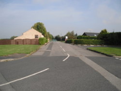
This is the section off Paradise Lane (road from the r/bout to Bramham, which was the 'GNR')
Note the kerbstones in front of the bow-windowed cottage (1)
499165


White Hart Inn, which became 'Cross-Roads Farm'
499166


The roof is really suffering now

It's owned by Leeds University
499167


https://www.geograph.org.uk/photo/5296229


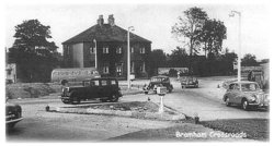
1. A circa 1910 image
Note the cottages & kerbs
499168


2. 1950s?
499169
 
Today
A ride around/through; Aberford, 'Bramham Cross-Roads', Barwick-in-Elmet

#5

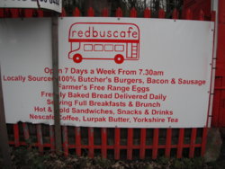
Red Bus Cafe

A brief ride west, along the A64, from Bramham Cross-Roads (with some awful surfaces at points!!)
Traffic wasn't too bad, but it's years since I've even been along this stretch in the car, or on the bike


499172


499173


Looking east....
Leeds Country Way (bridleway...... too soggy to investigate) enters/leaves Saw Wood, just in front of the people-carrier
499171


https://www.yorkshireeveningpost.co.uk/news/leeds-famous-red-bus-cafe-a64-close-248417

https://www.geograph.org.uk/photo/140442
 
Top Bottom