The CC Trig Point bagger thread, now incorporating other interesting geographs

Page may contain affiliate links. Please see terms for details.
My first worthwhile post on this thread.
Mile marker along an old road which is now a bridle path near Alton, Staffs.
IMG_1426.jpg
 

PeteXXX

Cake or ice cream? The choice is endless ...
Location
Hamtun
My first worthwhile post on this thread.
Mile marker along an old road which is now a bridle path near Alton, Staffs. View attachment 470921
And here's to many more :okay:
 

PeteXXX

Cake or ice cream? The choice is endless ...
Location
Hamtun
I had some time to kill between the Orkney Ferry, and my train home from Aberdeen, so I popped out for a pedal around the town.

_20190615_192255.JPG


This old fort/gun emplacement is on the clifftop overlooking the entrance to the harbour.

DSC_1637.JPG


The BM is on the corner by my rear wheel.

DSC_1636.JPG

Part of the traversing rail for the gun.

DSC_1635.JPG


Pleased to spot the BM.

DSC_1634.JPG


DSC_1633.JPG


Not sure what the standing stone at the top is for, but there it is!

Much better fun, and more productive, than 6 hours sitting in a railway station, I reckon..

:tongue:
 
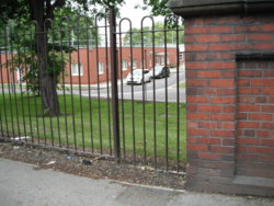
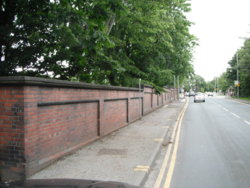
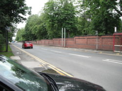
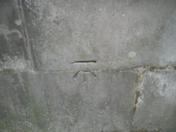
Boundary wall of Pinderfields General Hospital
Aberford Road
Stanley (as it still 'officially' is at this point)
Wakefield

This is the only remaining section of wall, all others have been replaced by 'hooped top' railings

DSCF9330.JPG


I rarely pass this, as if I'm going home from work, I travel down Bar Lane, to the north of the site, as can just be seen in the 3rd image (with my car; in the left-corner)
I only noticed it, as I was in the car, & happened to glance into the grounds, at that moment

Looking into the grounds, at the Diabetes Centre
DSCF9329.JPG


DSCF9331.JPG


Parked in the entrance to Clarke Hall
Now sadly closed!!
Note the city boundary sign
DSCF9327.JPG

https://www.geograph.org.uk/photo/1210462
 
Last edited:

PeteXXX

Cake or ice cream? The choice is endless ...
Location
Hamtun
Another find on my way round Orkney was Wasswick Battery on a farm called Queenamuckle. I saw the site from the road, across farmland, saw cars there, so rode down and knocked on the farmhouse door to ask if it'd be alright to check the place out.
Got the nod, and spent a while looking around.

DSC_1567.JPG


DSC_1562.JPG


Now used for livestock..

DSC_1561.JPG


DSC_1560.JPG


DSC_1563.JPG


Happy to have been allowed to get into this place!
 

Bobby Mhor

Legendary Member
Location
Behind You
Maybe a sighting post, range finder, or a place for a heliograph?
I thought range finder too?

A couple from yesterday..
Larbert Old Church
Larbert church and bm.jpg


Kincardine, Clock Tower
KIncardine Clock Tower and bm.jpg


Found an unusual (to me) couple of gravemarkers(?)
Larbert memorial .jpg

cast in iron, a memorial to James Bruce, Abysinnian explorer

Larbert graveyard.jpg

note the use of stone and cast iron....
(the area close by has a history of casting PO Boxes (Carron and Machan)

the church does a Graveyard Tour on its annual open day, might keep an eye open for this, lots of old stones
 

classic33

Leg End Member
I had some time to kill between the Orkney Ferry, and my train home from Aberdeen, so I popped out for a pedal around the town.

View attachment 470922

This old fort/gun emplacement is on the clifftop overlooking the entrance to the harbour.

View attachment 470923

The BM is on the corner by my rear wheel.

View attachment 470924
Part of the traversing rail for the gun.

View attachment 470925

Pleased to spot the BM.

View attachment 470926

View attachment 470927

Not sure what the standing stone at the top is for, but there it is!

Much better fun, and more productive, than 6 hours sitting in a railway station, I reckon..

:tongue:
Used to get a bearing for the gunners. Possibly unable to see what they were firing at.
 
Top Bottom