The CC Trig Point bagger thread, now incorporating other interesting geographs

Page may contain affiliate links. Please see terms for details.
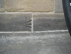
KirkGate railway bridge

Spanning the roads south-east out of Wakefield, for Barnsley, Doncaster & Pontefract

http://www.geograph.org.uk/photo/660602
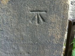
35656771_10214850255642219_4908495480083709952_n.jpg


The mark is just on the inside face of the right-hand face
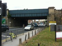
35735976_10214850254762197_9094330603439915008_n.jpg
 
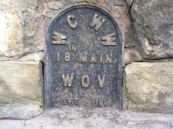
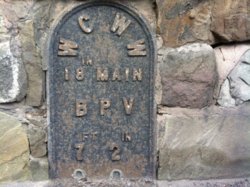
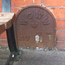
Wakefield Corporation Water Works

Despite riding/driving/running over this bridge for the 14 years we've lived here, I've never stopped to look at these before today!:blush:

All within 2 yards of each other
35653256_10214850237761772_6635959544470044672_n.jpg 35671563_10214850238441789_5056004740295426048_n.jpg 35701528_10214850237721771_4981142738771640320_n.jpg
 
Wakefield Corporation Water Works

Despite riding/driving/running over this bridge for the 14 years we've lived here, I've never stopped to look at these before today!:blush:

All within 2 yards of each other
View attachment 415093 View attachment 415094 View attachment 415095

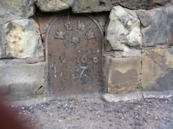
Now we just need to know what the bottom row numbers are.

They've been partially surfaced over, during course of years
Are you suggesting I go on a 'dig'?
 
(now) Halifax Building Society building
The Springs
Wakefield


It's on the building with the blue fascia board, on the right-hand side of the road
http://www.geograph.org.uk/photo/654386

DSCF5363.JPG


EDIT @ 14:45

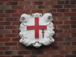
Coat of Arms, of the City Of London, apparently, & upside down here, as the Sword should be in the top-left 'quandrant'
Possibly something to do with the financial nature of the building?

I will find out
 
Last edited:
(now) Halifax Building Society building
The Springs
Wakefield


It's on the building with the blue fascia board, on the right-hand side of the road
http://www.geograph.org.uk/photo/654386

View attachment 415195


EDIT @ 14:45

Coat of Arms, of the City Of London, apparently, & upside down here, as the Sword should be in the top-left 'quandrant'
Possibly something to do with the financial nature of the building?

I will find out


It appears that the reasons are more prosaic than that, as there was a pub here called the 'London Hotel'
(I can't remember it)


Maybe, a reminder, as a previous building, of the Mail/Staging-Coaches that ran from Wakefield (or called en-route, from Leeds?)


EDIT @ 21:10
Can the old B&W photograph be seen?
 
Last edited:

Bobby Mhor

Legendary Member
Location
Behind You
Inchinnan, Braehead
NS 4823 6873 Inchinnan, Braehead Tavern, Building (450 x 600).jpg

Faint but still noticeable..

Not a NBM but found this on this, a navigation light (Erskine)
Beacon (450 x 600).jpg


The light...
IMG_1553 (1) (547 x 600).jpg
 

PeteXXX

Cake or ice cream? The choice is endless ...
Location
Hamtun
A few finds from yesterday's jolly around Cambridgeshire..

IMG_5876.JPG


Still in use, a VR letterbox in Grantchester.

IMG_5869.JPG


Nearby, a utility marker in Trumpington.

IMG_5879.JPG

Behind a security fence, is TP7125, New Farm, t the end of a bridleway. I did think of climbing over, but didn't want to end up clipping in to the top :laugh:. Years ago, this replaced the nearby TP3083 that was removed in 1950 and reused as Pudding Hill, Bracknell, TP 5536. Now that's recycling! :tongue:

IMG_5880.JPG

A Zoom shot. The FB is half covered in the ground, but intact by the bit I could see.

IMG_5895.JPG


A few miles away is Lords Bridge TP4543, that might be the lowest Trig Point around. 24 mtrs!
Just to the laft of my helmet can be seen one of the university telescopes. (More on those later.)

IMG_5894.jpg


Top spider is gone, and filled with pitch or summat. FB is in good nick though.

IMG_5884.JPG


On the way back from New Farm, I checked Great Eversden church.

IMG_5902.JPG


Final one, for this post, is a BM on a bridge in Fen Drayton.

:smile:
 

PeteXXX

Cake or ice cream? The choice is endless ...
Location
Hamtun
A few more from t'other days' jolly around Cambridgeshire.


IMG_5908.JPG

A pillbox, near Fen Drayton, that guards the A14 roadworks. I've spotted it through the undergrowth many times as I've driven past, but this was my first opportunity to actually visit!


IMG_5917.jpg


Through the gun port, looking to the left.
IMG_5918.JPG


Though the gun port, looking to the right.

IMG_5921.JPG

The next find was opposite the Park and Ride, in St Ives, where my ride commenced and finished. (I drove to the car park, rode to and around Cambridge for a family visit)

IMG_5922.JPG


There's access, but there's another bar welded just inside this grill. I couldn't see anything of interest in there either.

One more post to go on this foray! :laugh:

:smile:
 
Top Bottom