OP
OP
ColinJ
Puzzle game procrastinator!
- Location
- Todmorden - Yorks/Lancs border
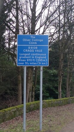
The full length of the hill is about 8.5 km from the Oliver Collinge sign in Mytholmroyd to Blackstone Edge reservoir at the top but I am using about 7.7-7.8 km of that, starting a few hundred metres further on and finishing a few hundred metres earlier. That is the hill climb time trial course used in an annual event.Can you provide information about the route?
How long is the route?
How much elv gain?
What is the average slope?
View attachment 760859
The elevation gain is around 290 metres, so the average gradient is only around 3.6-3.8%. It is fairly unchallenging apart from a few hundred metres at around 8%
midway, above Cragg Vale, and leading up onto the moor.
The biggest difficulty is often the wind on that moor. It is typically a blustery cross-headwind coming from the SW (ahead right).
This is what the reservoir surface typically looks like when you have battled your way up to it...
This is what you would prefer, but you have to pick your day carefully!
Today's wind is forecast to be 10 km/h with gusts of upto 22 km/h and further to the south than usual so even harder. I will leave my first attempt this year until another day!
There used to be painted lines on the road indicating the start and finish of the tt course but I think they have gone now. I linked to a map a few pages back showing the course.
The start is just before a driveway to the left here...
And the finish is here...
Note the gate and footpath to the right.
Last edited: