Game: Name that road!

Page may contain affiliate links. Please see terms for details.

MontyVeda

a short-tempered ill-controlled small-minded troll
Blimey - you lot have been busy while I have been away!

(I have been looking at potential routes for a forum ride with @Sea of vapours in the summer.)

I am still smarting at missing Ratcliffe Wharf Ln! I was looking all around there and it was exactly what I was looking for but somehow I missed it, despite having done many of the nearby roads several times. I must be more systematic rather than dashing about all over the place.

Here is a sketch I did to remind myself what I was looking for...

View attachment 631319
I know the feeling... the two windmills in Cambridgeshire... I actually looked at the next bend in the road and dismissed it :sad:
 

roubaixtuesday

self serving virtue signaller
I keep meaning to do a Settle to Carlisle railway by bike route... it's got a nice ring to it.

Beware the Old Coal Road, my son!
The bends that bite, the ramps that catch!
Beware the Mallerstang bird, and shun
The frumious Great Dun Fell
 

Mr Celine

Discordian
About 30 years ago I accompanied the now Mrs Celine on a Duke of Edinburgh training expedition for some of her pupils. We were supposed to rendezvous with another group for an overnight camp in the next glen on the right. We had great difficulty finding the other party as the teacher in charge of organising the DofE, who was notoriously mean with equipment, had given us maps so old that the reservoir wasn't on them. I think the proposed campsite was actually underwater. :laugh:

The eastbound descent from the Megget Stone towards the reservoir is steeper than it looks and can catch out the unwary. There was a fatality there on the Peebles cycling club's sportive a few years ago.
 
OP
OP
ColinJ

ColinJ

Puzzle game procrastinator!
We had great difficulty finding the other party as the teacher in charge of organising the DofE, who was notoriously mean with equipment, had given us maps so old that the reservoir wasn't on them. I think the proposed campsite was actually underwater. :laugh:

My digital OS maps are a bit out of date. I noticed looking for @MontyVeda's most recent road that the A683 has been extended to the M6.

631470


If I hadn't invested about £200 in those old maps I would go for an OS map subscription now to keep up with changes.

I discovered a missing road in Devon after old clay quarries were closed and new ones opened - the quarries and road had swapped places!
 

MontyVeda

a short-tempered ill-controlled small-minded troll
My digital OS maps are a bit out of date. I noticed looking for @MontyVeda's most recent road that the A683 has been extended to the M6.

View attachment 631470

If I hadn't invested about £200 in those old maps I would go for an OS map subscription now to keep up with changes.

I discovered a missing road in Devon after old clay quarries were closed and new ones opened - the quarries and road had swapped places!
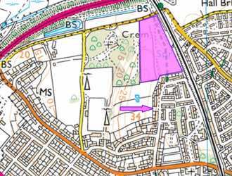
I was toying with subscribing to OS maps a few weeks ago and gave their free trial a bash but wasn't impressed because it didn't appear to be at all up to date.

This is the screenshot i took...
631552
They put the Bay Gateway (A683) in, but the gap in the housing (pink arrow) was built on about 20 years ago... and the pink field (my highlight) next to the Crem has been woodland for 30+ years, which is shown as woodland on your screenshot. So your maps are more up to date in some respects than what they showed me in the free trial :ohmy:
 

Dogtrousers

Kilometre nibbler
🤹‍♂️ 🏍️ 🇩🇪
For those like me who can't read these very well, here they are in golden technicolor
1645176520556.png

Juggle(r); Motorcycle; Circular German flag.

Could be an anagram of BMW.

The road itself reminds me in some ways of the Yorkshire Wolds. I don't think it is the Wolds, but maybe it is the top of an undulating plateau like the wolds (or the NY Moors), and a bit further down the road the ground will fall away.
 

T4tomo

Legendary Member
Could be an anagram of BMW.
I think its a Ducati:wacko:
 
Top Bottom