Do I really need Ride with GPS?

Page may contain affiliate links. Please see terms for details.

chriswoody

Legendary Member
Location
Northern Germany
As a general rule I like to be kept off major roads between towns, where traffic speeds are higher, but I don't mind joining these routes through towns. But the algorithm doesn't (and can't) know this and often shoves me on crappy footpaths through towns.

It's a general problem with all automated routing algorithms - we all have different tastes and no algorithm can be attuned closely to these tastes.

I also find the global heatmaps useful in these situations as well, just gaining a little idea of where the local cyclists are going helps build a picture.
 

T4tomo

Legendary Member
It may have an indicator to tell you the road is unpaved, but that doesn't stop it trying to send you down it.

You have tio check the proposed route for unpaved sections, then add waypoints to force it to go some other way for those bit. Perfectly doable, but fiddly.

if you don't check any route that any software comes up with, then you deserve all you get!

for reference / info, the unpaved is very easy to see as it shows up red and white on the route and profile. Its not really that fiddly to amend a route, particularly on the desktop version (vs mobile)
 

Mburton1993

Über Member
Location
Stalybridge
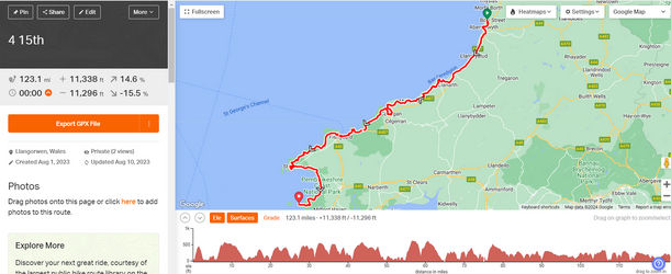
In my experience Ride With GPS is good at indicating paved/unpaved bits, what it's not great with is gradients (although that may not be unique to RWGPS). For my Wales ride last year I mapped out the routes so that I wouldn't be going up hills greater than 15% but by the end of the first day I was fairly certain there had been steeper than that, at the end of the second day there were three signed 17%'s in a row and throughout the rest of the week there were plenty of +15%'s a few 20%'s.

I assume because I was on alot of B roads and country lanes that RWGPS simply didn't have the information.
 

Dogtrousers

Kilometre nibbler
In my experience Ride With GPS is good at indicating paved/unpaved bits, what it's not great with is gradients (although that may not be unique to RWGPS). For my Wales ride last year I mapped out the routes so that I wouldn't be going up hills greater than 15% but by the end of the first day I was fairly certain there had been steeper than that, at the end of the second day there were three signed 17%'s in a row and throughout the rest of the week there were plenty of +15%'s a few 20%'s.

I assume because I was on alot of B roads and country lanes that RWGPS simply didn't have the information.

Gradients ... Now that's another story altogether. ^_^ No one can agree on what the true gradient of a hill is. Do you trust OS chevrons, GPS devices, mapping software, road signs, a slope measuring app ... or what? They are all averaged over different distances, using different data.
Best thing to do in my experience is ignore the gradient figures and look at the profile. How spiky is it?

A thread all about it: https://www.cyclechat.net/threads/a...radients-using-route-mapping-software.293019/
 

Mburton1993

Über Member
Location
Stalybridge
Gradients ... Now that's another story altogether. ^_^ No one can agree on what the true gradient of a hill is. Do you trust OS chevrons, GPS devices, mapping software, road signs, a slope measuring app ... or what? They are all averaged over different distances, using different data.

Best thing to do in my experience is ignore the gradient figures and look at the profile. How spiky is it?

A thread all about it: https://www.cyclechat.net/threads/a...radients-using-route-mapping-software.293019/

Ha, that thread was less than a month before the off, wish I read it beforehand. 😅

4 15th.png

Day 4 was probably the most spiky. I did not trust RWGPS's 14.6% max by that point.
 
Top Bottom