Richard A Thackeray
Legendary Member
Bike selected; Gran Fondo. Bone-dry roads, & I was intending to stick to the tarmac
Weather; quite warm, broken cloud-cover, a slight breeze
Photographs from today; unless dated otherwise
Geograph used, to illustrate points not covered by my own images (& to give a map location)
First off!!
Apologies, as I may ramble on about locations that I pass. not where I'm going to end up
As usual...……………
Not a long ride, more of a 'potter' to take some photographs, for the albums on my 'social media' (just FaceBook), and for the various photography threads on here
Out over the railway bridge, adjoining Normanton Station (the merest/slightest shadow of its former self), through Lee Brigg (an 'annex' of Altofts)
Down Birkwood Hill, the 'tarring & chipping' of a few years ago, now resembling a 'scalping', with the road actually starting to dip several inches at points, between drains!
Over the Aire & Calder Navigation Canal. at 'Stanley Ferry', on this bridge, heading from right to left; http://www.geograph.org.uk/photo/191204
Crossing the River Calder, on this bridge, heading towards the camera; http://www.geograph.org.uk/photo/4008710
With the Grade 1 listed Aquaduct carrying the 'A&CNC' over the Calder, to my left; http://www.geograph.org.uk/photo/3511340
To the end of Ferry Lane, ignoring the Trans-Pennine Trail & Wakefield Wheel signs along the (as it's known locally 'Nagger Lines', as it was a horse-drawn wagonway) the new Nellie Spindler Drive heads off, as part of the Eastern Relief Road
Who?, this courageous lady, buried with full military honours, & the only woman buried with 10,000 Soldiers
https://www.bbc.co.uk/news/uk-england-leeds-40976974
On to the Wakefield - Aberford TurnPike Road, as it was created during 1788 - 1789, to be (now just A642 Aberford Road) through Stanley, past the demolished St Peters Church
http://www.geograph.org.uk/photo/1182507
On the right, there's Gordons Tyres, a tyre/exhaust distributor that took over the old Cinema building
Originally known as the 'Clog & Rhubarb', as those were the two biggest products of the area (after Coal), with WH Lambs, known as 'Clogger Lambs being exactly that; a Clog/boot factory
The local farmers, & 'Cloggers', provided the land, and built the cinema; http://www.geograph.org.uk/photo/966696
Opposite, the former Toll-House, on the corner with Lake Lock Road, with a curved wall
Tuesday 3rd January 2017
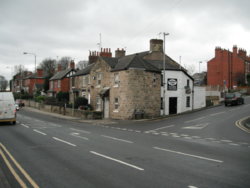
Then there's the Mechanics Institute, now an office (or was, for a damp-proofing company)
Monday 3rd May 2004
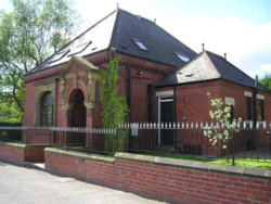
Followed on by the site of Stanley Station, now The Chase, sheltered housing & OAP bungalows in the trackbed, a platform wall is still there, as a retaining wall
As we get further up Aberford Road, it's changed greatly, as there was a railway line here, & the original (well, up to late 60's?) road climbed to cross it on a bridge
The 60's route can still be seen/followed as a footpath, up to the previous road-junction
The new road-layout can be seen here - if you change the 'transparancy', Newmarket House was a bar/restaurant, for a few years
Best displayed on desk-top/lap-top
https://maps.nls.uk/geo/explore/#zoom=17&lat=53.7247&lon=-1.4599&layers=168&b=1
Next, it's the sprint across the roundabout that's over junction 30, of the M62, taking primary over the slip-road, & watching for traffic coming up the 'off' to join Aberford Road
A fairly good stretch of road now, but busy towards Oulton, & Rothwell Sports Centre
Down to the next roundabout, where there's the lovely 'Nookin' (a magnificent 'half-timbered' house, with a date of 1611 - though some believe that's a date of rebuild, not actual construction)
Friday 30th April 2004
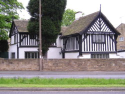
Turning right at the roundabout, into Oulton itself, the first stop is the old School, built in 1877, & closed in 1966
https://www.britishlistedbuildings....and-primary-school-rothwell-ward#.W2gVkfZFzIU
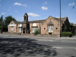
The Methodist Chapel, for the 'Trig Point bagger thread'
A side trip around Farrer Lane, which has a few of the old houses was partaken of
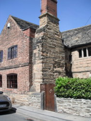
This is 'Tudor Cottage', as it's named by the owners, the name-plaque has the date of circa 1500
https://www.britishlistedbuildings....and-13-farrer-lane-rothwell-ward#.W2gWMPZFzIU
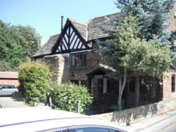
Number 21/23 is (apparently) a Victorian conversion
No!!, not a converted Victorian barn.... .but converted in the Victorian era!!!!!
(I'd hazard a personal guess, that the cart-door was blocked up then, & it was still used for agricultural purposes?)
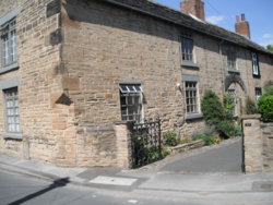
Then, there's a house with some serious money...….
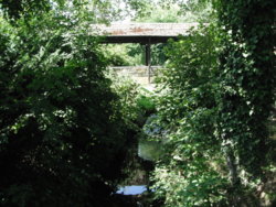
This bridge isn't a folly/remnant of the landed gentry
It's from a house.. over Oulton Beck (oddly, the River Dolphin, upstream in Rothwell) to their garages!!!!!!
I'm running out of time now, so will have to leave the trip there
Hope someone enjoyed it??
Weather; quite warm, broken cloud-cover, a slight breeze
Photographs from today; unless dated otherwise
Geograph used, to illustrate points not covered by my own images (& to give a map location)
First off!!
Apologies, as I may ramble on about locations that I pass. not where I'm going to end up
As usual...……………

Not a long ride, more of a 'potter' to take some photographs, for the albums on my 'social media' (just FaceBook), and for the various photography threads on here
Out over the railway bridge, adjoining Normanton Station (the merest/slightest shadow of its former self), through Lee Brigg (an 'annex' of Altofts)
Down Birkwood Hill, the 'tarring & chipping' of a few years ago, now resembling a 'scalping', with the road actually starting to dip several inches at points, between drains!
Over the Aire & Calder Navigation Canal. at 'Stanley Ferry', on this bridge, heading from right to left; http://www.geograph.org.uk/photo/191204
Crossing the River Calder, on this bridge, heading towards the camera; http://www.geograph.org.uk/photo/4008710
With the Grade 1 listed Aquaduct carrying the 'A&CNC' over the Calder, to my left; http://www.geograph.org.uk/photo/3511340
To the end of Ferry Lane, ignoring the Trans-Pennine Trail & Wakefield Wheel signs along the (as it's known locally 'Nagger Lines', as it was a horse-drawn wagonway) the new Nellie Spindler Drive heads off, as part of the Eastern Relief Road
Who?, this courageous lady, buried with full military honours, & the only woman buried with 10,000 Soldiers
https://www.bbc.co.uk/news/uk-england-leeds-40976974
On to the Wakefield - Aberford TurnPike Road, as it was created during 1788 - 1789, to be (now just A642 Aberford Road) through Stanley, past the demolished St Peters Church
http://www.geograph.org.uk/photo/1182507
On the right, there's Gordons Tyres, a tyre/exhaust distributor that took over the old Cinema building
Originally known as the 'Clog & Rhubarb', as those were the two biggest products of the area (after Coal), with WH Lambs, known as 'Clogger Lambs being exactly that; a Clog/boot factory
The local farmers, & 'Cloggers', provided the land, and built the cinema; http://www.geograph.org.uk/photo/966696
Opposite, the former Toll-House, on the corner with Lake Lock Road, with a curved wall
Tuesday 3rd January 2017

Then there's the Mechanics Institute, now an office (or was, for a damp-proofing company)
Monday 3rd May 2004

Followed on by the site of Stanley Station, now The Chase, sheltered housing & OAP bungalows in the trackbed, a platform wall is still there, as a retaining wall
As we get further up Aberford Road, it's changed greatly, as there was a railway line here, & the original (well, up to late 60's?) road climbed to cross it on a bridge
The 60's route can still be seen/followed as a footpath, up to the previous road-junction
The new road-layout can be seen here - if you change the 'transparancy', Newmarket House was a bar/restaurant, for a few years
Best displayed on desk-top/lap-top
https://maps.nls.uk/geo/explore/#zoom=17&lat=53.7247&lon=-1.4599&layers=168&b=1
Next, it's the sprint across the roundabout that's over junction 30, of the M62, taking primary over the slip-road, & watching for traffic coming up the 'off' to join Aberford Road
A fairly good stretch of road now, but busy towards Oulton, & Rothwell Sports Centre
Down to the next roundabout, where there's the lovely 'Nookin' (a magnificent 'half-timbered' house, with a date of 1611 - though some believe that's a date of rebuild, not actual construction)
Friday 30th April 2004

Turning right at the roundabout, into Oulton itself, the first stop is the old School, built in 1877, & closed in 1966
https://www.britishlistedbuildings....and-primary-school-rothwell-ward#.W2gVkfZFzIU

The Methodist Chapel, for the 'Trig Point bagger thread'
A side trip around Farrer Lane, which has a few of the old houses was partaken of
This is 'Tudor Cottage', as it's named by the owners, the name-plaque has the date of circa 1500
https://www.britishlistedbuildings....and-13-farrer-lane-rothwell-ward#.W2gWMPZFzIU


Number 21/23 is (apparently) a Victorian conversion
No!!, not a converted Victorian barn.... .but converted in the Victorian era!!!!!
(I'd hazard a personal guess, that the cart-door was blocked up then, & it was still used for agricultural purposes?)

Then, there's a house with some serious money...….
This bridge isn't a folly/remnant of the landed gentry
It's from a house.. over Oulton Beck (oddly, the River Dolphin, upstream in Rothwell) to their garages!!!!!!

I'm running out of time now, so will have to leave the trip there
Hope someone enjoyed it??

 . 100.5 miles bagged at 18mph with 5267ft of elevation with a group pub stop near the end, that was nice . Great ride with all of us sticking together and seeing it through as a group. Great day

 .Longest for a bit,don't get impressed it was only Boston Spa via Thorner flat as a pancake,with just a couple of stretches.Now sad thing is my mate Dave,we cycled together for the first time today.For some reason known only to him,he has bought a 29 er.A chunky mountain bike with tyres like a motorcycle.He is 72 and it it too heavy for him.At one stage we were doing 4.4 to 5.2 mph.Because of that he was wobbling allover the place,i can see how he fell off last time he was out with his other cycling buddy.He is going to put slicks on to see if it improves things,i hope it does.I felt awful when he told me to set off on my own,as he was going to walk up the road as it gently started to rise.I set off and got going to 18mph within seconds.I hope the slicks do make a difference,because i can see it is spoiling his enjoyment and rides of any distance over 30 miles,will be difficult for him.He also said he might sell it,he has only had it about nine months,and never even taken it out on a tow path.It was great to be out with him.