Your ride today....

Page may contain affiliate links. Please see terms for details.
My mate is who was 2nd in yesterday’s regional TT was meeting a young mate (half my age) for an off road (gravel bike) training session. Somehow I doubted I could hold the pace (especially down technical stuff) so I agreed I’d meet them at the cafe in Fineshades. I posted I’d go by another meet. But about 0.75iles from my house I realised I’d left my cafe lock so doubled back and have to hammer it to the meet into a strong NW wind. Lol, no one was there so after taking some selfies it was on to the cafe at a more sedate pace. After the cafe though I rode with my mate and the young gun and I was right, I could hold my pace on the flat and uphill I was slightly faster (they’d been riding flat out for 2hours) but downhill on technical stuff I lost them. But it was quite fast for me for the hour and a half home.

image
image

869d12f2b60d5334ef6b2b7c04ecd67ff3f09f09_2_375x500.jpg

image

Then it was back to the usual dilemma

This:

image


Or:

image
 

Windle

Über Member
Location
Burnthouses
The only safe road cycling route to Staindrop these days would be through Raby Castle. Even the back road towards Darlington via Staindrop is now extremely busy.
The off road Hilton route is very much a mixed bag.

The old rail line from West Auckland goes all the way to Kirkby Stephen through Barnard Castle. It could be a fantastic tourist trail too.

I've always thought it would be great if the roads in the Raby Castle grounds were open to cyclists, there're loads of them snaking about the place and it would make a superb place for leisure riding, even if they allowed visitors to the castle grounds the run of the place. There're only so many bits of it that you can access now. You're right about the roads around Staindrop though, probably the only quiet one is the road through South Cleatlam and that only really heads to the A67 anyway.
It's a pity the railway path stops at Ramshaw although the route does supposedly continue through the holiday caravan park and then up to Lands as a bridleway, it never looks passable at the Lands end though. After that it goes over Cockfield Fell, which I ride regularly then about half a mile after crossing the Slack bank road there is brief section of proper bike path that the council did years ago, stopping due to land purchase issues. a shame as they were originally intending to continue to Barnard Castle. This is the brief paved section, looking very verdant from last summer.

GOPR0217.JPG
 

albion

Guest
If you look at an OS map for Ramshaw you will see the bypass main line that goes into Ramshaw then back to the river line.
Puzzling how they had 2 lines for a tiny section.

It is a big shame how the UK underplays the rail and canal heritage as a destination for active holidays/travel.
Plus dog walkers seem to make as much if not more use than bikes or hikers.
 

Windle

Über Member
Location
Burnthouses
If you look at an OS map for Ramshaw you will see the bypass main line that goes into Ramshaw then back to the river line.
Puzzling how they had 2 lines for a tiny section.

It is a big shame how the UK underplays the rail and canal heritage as a destination for active holidays/travel.
Plus dog walkers seem to make as much if not more use than bikes or hikers.

The southernmost line that branches off just before Ramshaw (and the route that the bike path changes onto) is the Haggerleases branch that runs alongside the river Gaunless and eventually underneath the main line to Barnard Castle, beneath the long gone viaduct. The route changes to a footpath at the caravan park and comes out near the bottom of Lands bank. The bridleway alternative deviating from the main railway line and eventually coming out at Bluestone Farm, which is the bit that looks impassable for either loads of dumped farm stuff of usually a giant puddle around the gate area.
I think eventually more and more of the old railway paths will be turned into cycleways / footpaths, think back thirty or forty years and see how many more routes we've got now compared to back then.
 

Rickshaw Phil

Overconfidentii Vulgaris
Moderator
Catching up after a busy weekend of rides.

Friday: This was the first chance I'd had to get out in the week. I got the Hawk out and decided to do one of my longer regular routes that hasn't been accessible for a while due to a bridge closure. It was quite windy and cold out but there was sunshine, which is always nice.

I set out with a tailwind for roughly the first three miles and really enjoyed scooting along quickly on a section where I'm more used to a headwind. It's a shame I forgot to start Strava for the first half a mile. Having had that quick run to Condover I had to work a bit harder than usual on the way to Upton Magna but it got easier again from there. Bluebell lane was much easier than usual. It would have been good to get a pic of the bike with some bluebells here but there were none to be seen.

The blustery wind carried on helping through Eaton Constantine and meant an exhilarating descent to Cressage Bridge where there is now smooth tarmac after the bridge deck was replaced. As I turned the corner to cross the bridge a gust of wind dropped my speed from 20 down to 10 as rapidly as if I'd slapped on the brakes - not sure what the driver of the following car thought of that.

From Cressage I had mostly crosswinds through Acton Burnell then a bit of protection from the hedges on the lane from Longnor back to Condover. With it being a Friday afternoon I thought that crossing Lyth Hill would be preferable to plodding into a headwind on the busy A49.

34.7 miles at 13.4 mph average. Strava has 1500 feet of climbing. Great to get out but quite hard work in the conditions. It's nice to finish the ride with the bike still clean, for the first time in months.

20240419_133529.jpg

The view to The Wrekin from Berrington.

20240419_141756.jpg

....and the same from Uppington.

20240419_143907.jpg

This one didn't come out very well - en route from Cressage to Cound Moor.

20240419_152705.jpg

Pheasant thinks I can't see him.

------------------------------------------------------

Saturday: I managed to get my brother out again. I had planned to go to Stretton again via a different route but he was late getting up (working 'til near midnight is a fair excuse) so we opted to repeat the direct route from last time so as to get to the Hollybush Cafe before it got too busy.

The weather was bright, felt warmer than it said on the thermometer and we had a light northerly wind on this occasion so it was quite a bit easier going than our previous ride together. Doug got quite enthusiastic and pressed on so that I had to put in some effort to keep up on the Hawk. We made good progress and got to Stretton in good time to beat the rush...... which didn't come this time. The weather was really excellent for cycling but in the time we were there we only saw a handful of cyclists.:unsure:

After lunch we made our way to Leebotwood via Dudgeley and had a stop at The Pound again. They seemed to be doing quite a good trade this time but we still had our pick of tables outside and enjoyed a pint (Ludlow Gold for me) before moving on again. The return was into a wind that seemed to have picked up a little since we set out so the pace was a bit more leisurely. Doug suggested crossing Lyth Hill for much the same reason I had the previous day.

26.3 miles at 12.4 mph average. 1128 feet of climbing apparently.

20240420_105012.jpg


20240420_105027.jpg

A couple of shots taken at our usual spot to pause just outside Ryton.

20240420_123353.jpg

Drinks at The Pound again.

20240420_134757.jpg

Crossing Lyth Hill on the way back. There are more brown fields than there ought to be for the time of year due to the wet Winter and Spring.

20240420_134816.jpg

I think Doug has enjoyed it.
 
Last edited:

a.twiddler

Veteran
If you look at an OS map for Ramshaw you will see the bypass main line that goes into Ramshaw then back to the river line.
Puzzling how they had 2 lines for a tiny section.

It is a big shame how the UK underplays the rail and canal heritage as a destination for active holidays/travel.
Plus dog walkers seem to make as much if not more use than bikes or hikers.

It's interesting to see how even the semi derelict canals that survived into the mid 20th century managed to continue long enough in a recoverable state for the recreational boating enthusiast movement to be able to bring them back to life and for their towpaths to be now usable for walkers and cyclists. Those that perished sooner, mainly due to the influence of railway competition, are often almost untraceable on the ground unless they had a railway built on their route, and even that might have gone in the '60s and had a bypass built on it.

Despite all this, railways that closed in the early days of British Railways seemed more likely to be visible on the ground for decades afterwards, maybe with bridges or other maintenance-heavy structures removed, and better candidates for conversion into recreational routes than railways that closed in the '90s or early 2000s and were swallowed up under new developments almost immediately. Perhaps the archetypal rural railway, with its meandering route, little traffic and stations often a mile or two from the hamlet whose name they bore, was less desirable to roadbuilders than lines that survived till later, where the industries or communities they served were more densely packed and greedy for space.

If you follow a canal towpath for any distance, sooner or later you will come across a bridge or similar structure remaining from a disused railway which came after the canal yet didn't outlast it. It really is surprising how all these potential resources aren't made more use of. In my area of Cheshire we are lucky to have recreational facilities but it is a touristy hotspot. In other areas, not so much.

There were high hopes in the '80s that the likes of Sustrans would be able to coordinate some sort of joined up national system for cyclists and walkers but it still remains fragmented with no guaranteed standard. So many resources remain undeveloped and the longer they do, the more difficult and expensive it might be to bring them back to life. The transient Governmental enthusiasm for active travel has evaporated, and with it the funding for local authorities or user groups.
 
Last edited:

Rickshaw Phil

Overconfidentii Vulgaris
Moderator
Yesterday: I joined Gav and Paul for their next step up in sportive training. The aim this time was to get over the 70 mile mark. With the roads dry I thought I'd get the Galaxy out for its first ride of the year (also its first in 11 months) and met up with Gav (who had brought out his carbon bike) before reaching our rendezvous point.

After picking up Paul we headed out of town through new estates and headed for Montford Bridge, Shrawardine, Pentre, The Royal Hill and Melverley at a sociable pace. On the way to Maesbrook we overtook another rider who took the chance to tag along and get a bit of a tow into the headwind. We'd probably have stayed together a bit longer but we paused to chat with a friend of Paul's.

A meandering route round the lanes to Kinnerley and Knockin Heath kept us off roads that were too busy (or just had fast traffic). Near to Shottaton we'd just turned into a lane when a passing dog walker said "I hope you've brought arm bands" - a farmer had cut a trench to drain a flooded field and it was in the process of filling the lane up instead. We went and had a look but decided to err on the side of caution so headed back and went round via Ryton XI Towns and Wykey instead. With it being a Sunday there was plenty of activity at the karting and paintball centres at Rednall. We had a pause for jelly babies here then carried on to Hordley (a couple of iffy overtakes on this road), Tetchill, Spunhill and Colemere which seemed a good place to pause for lunch.

Lyneal was next up after our stop and we picked up a tailwind which lasted most of the rest of the trip. We had to duck into a gateway to avoid two huge tractors on the way to Loppington but thereafter had a fairly decent run to Noneley. There must have been an event going on at Sleap airfield as an aerobatic display started as we approached and had us enthralled for a while. We couldn't stop for too long but carried on past Myddle on our way to Yorton. A missed junction was the only incident as we headed for Hadnall and Astley before taking the flatter but longer route via Bings Heath, Poynton Green, Roden and Rodington Heath.

With our earlier detour we would easily hit the target distance for the day but we were still going fairly well so Gav stuck to the planned route with an extra loop of lanes to take the long way into Withington. The pubs at Upton Magna and Atcham were passed with increasing reluctance but if we'd stopped it may have been tricky to get going again so we carried on to Berrington (with Paul surprising me by sprinting past up the short but sharp climb at Cronkhill) and back to town via Weeping Cross. After parting from Gav and Paul the rare north-easterly tailwind helped me home.

Just over 78 miles by the time I got back at 12.8 mph average. 2516 feet of climbing recorded. I think Gav and Paul did really well. They have more training rides planned and after this one I'm confident they are well on track to be ready for the day.:thumbsup:

20240421_112855.jpg

Possibly we could have waded through but we decided against.

20240421_115957.jpg

Karting action at Rednal.....

20240421_123422.jpg

.....and sailing action at Whitemere.

20240421_130610.jpg

Lunch stop at Colemere - no sailing going on here. Do those boats ever go out???

20240421_134330.jpg


20240421_134340.jpg


20240421_134352.jpg

They've put on an air show for us at Sleap.
 

lazybloke

Today i follow the flying spaghetti monster
Location
Leafy Surrey
Went out after dinner last night for a ride in the Surrey Hills; with an objective to gauge my strength for the undulating Isle of Wight Randonnee, which is fast approaching.


Opted to return home early because I'd forgotten to take a pump, but did 15 miles and nearly 1500 feet of ascent(s). The randonnee wil be 5000 in 65.
(Conclusion: i could be lighter and fitter).

There's a flat valley route between Leatherhead and Dorking, but i took the hills to either side (Box Hill and Ranmore).
1713913166496.png
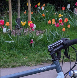
Tulips in fading evening light


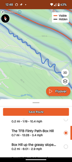
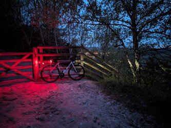
1000009781.jpg Long exposure near top of Box Hill. What possessed me to ride up this bridleway with road tyres, i dont know. Very flinty in places too, which was worrying with no pump!

Rear wheel was slipping in the grassy bits, so i had to meander to reduce the gradient. The dynamo light alternates between an optimistic flicker and the dim standlight; a crushing measure of my fitness.

1000009799.png

Full moon (overexposed and over zoomed). Saw a badger in Westhumble, or possibly a werebadger.
1000009783.jpg

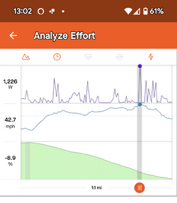
Quite enjoyed this descent of Ranmore. Not my fastest, but 42mph in the dark was a hell of an adrenaline rush!
1000009800.png
 
A short ride into town today, then I had planned to go to Oxford for a few hours for a look-see.
However, after locking the bike up, I walked along and saw the bus to Henley, and as I got nearer I heard the driver say to a boarding lady that the ticket machine was broken and she should just hop aboard.
I duly did likewise, never look a gift horse in the mouth - that's a whole 2 quid saved!
In Henley, I walked along the Thames to the village of Hambledon, and took a few pics, as you do

Millhouse.jpg

This is the old millhouse, no longer in use as such, but very pretty just the same

Marina.jpg

The marina was busy, boats being dropped into the water, ready for the elusive clement weather.

All in all a pleasant half day out, and an unexpected location thanks to serendipity.
 

Rickshaw Phil

Overconfidentii Vulgaris
Moderator
Yesterday: I've done some tinkering with the Raleigh and also fitted some new tyres which I thought would be good for the summer - those are Goodyear Eagle Sport in 700x32c. A test ride was needed and the longer version of my Acton Burnell route seemed like a good option for that and I thought that going round clockwise would make the most of the wind direction.

Starting out, the tyres made the bike feel quite lively compared to the Vittoria Revolution Tech ones that I'd just taken off and on my way to Condover I was making very good progress. I did have a tailwind at this point so I didn't want to read too much into it just yet. Turning along Lyons Lane the good speed kept going. Reaching Cross Houses the main road wasn't too busy and is slightly downhill in this direction, which is always good. I'd hoped the fast riding would continue after turning off towards Cound Stank but I met several vehicles I needed to pull in for and also had a stop for a small adjustment.

On reaching Cound the flag of the day was the St. Georges Cross, then the climb to Harnage seemed easier than usual. The long straight to Cound Moor also felt really easy and I'm not used to a 16mph cruising speed riding it in this direction. After Evenwood I turned into the wind for a while and there is a short, sharp climb which brought things back down to earth a bit. I was enthused to push on though so, after passing through Acton Burnell, climbed to Frodesley quite nicely and enjoyed the descent towards Longnor. Here I turned back into the wind for the remainder of the ride but still enjoyed a reasonable run back to Condover and up to the A49.

Just under 24 miles for this one with 15.8 mph average on my speedometer. 1025 feet of climbing.

I really enjoyed that one. The new tyres have made a good first impression. They feel fast and the numbers back that up. The ride has a suppleness similar to the Voyager Hypers which I really like on the Galaxy (but are no longer available). The only downside so far is that they measure up small on my rims (29mm width rather than 32) so they look a little lost under my mudguards - I'm sure I can live with that though. More rides needed but they seem to be what I was hoping for so far.

20240424_152816.jpg

Just the one shot this time at the crossroads near Longnor.
 
Last edited:

Rickshaw Phil

Overconfidentii Vulgaris
Moderator
It was a nice morning so I took the chance to get out. I thought it was about time that the Kingpin had an outing so got that out and set off into town. The old bypass took me round to Porthill where I had a bit of a detour to see if I could spot my brother at work - he was in the process of setting up for the day so apart from saying Hi I didn't bother him.

There were a reasonable number of people walking in The Quarry and along the river towpath. Not as many cycling though. By Castle Walk footbridge I had an involuntary detour through Castlefields as the path is still closed off after a lorry fell through the surface. I took the long way round to avoid the canal path - it's probably dry enough but I thought I'd like the extra distance this time - then headed for Uffington and Upton Magna.

With the forecast wind direction I thought I'd have a tailwind from here but still seemed to be riding into it, particularly on the road from Berwick Wharf to Atcham, which was a little disappointing. I got along alright to Cronkhill but this was where things went wrong a bit as I got that tell-tale spot in my vision that signifies a migraine coming on. I took it carefully to Cross Houses, Berrington and along Lyons Lane and by Condover I could see properly again so risked the main road route back rather than crossing Lyth Hill which I had been thinking would be sensible under the circumstances.

An enjoyable ride, up to a point, and it was really nice to use this bike again. 22.4 miles at 12.6 mph average and 785 feet of climbing.

20240426_100117.jpg

The Welsh Bridge and Theatre Severn.

20240426_100244.jpg

Sabrina being prepared for the day.

20240426_100520.jpg

In The Quarry.

20240426_100959.jpg

The English Bridge.

20240426_101609.jpg

At the weir. It's a bit calmer than when I was last here.

20240426_101646.jpg

Work to fix the hole doesn't seem to be progressing.

20240426_104143.jpg

Near Downton en route to Upton Magna.

20240426_110109.jpg

Cronkhill.

20240426_110118.jpg

No, actually it's a Kingpin.:whistle:
 
Out to the Elton Furze meet for the group ride expecting no one to show up but one of my mates appeared (he hadn’t said he could make it but his young kids and wife were sound so he made it out
:slight_smile:
). We then had a fairly relaxed ride until Aldwinkle where we turned and went directly into the head wind. After a few minutes of that, he asked if he could draft. My hand was on the edge of numbness due to lack of circulation so I was glad to oblige and get the blood flowing
:smiley:
We met my uber strong mate at the cafe and he was on openers for a race tomorrow so there was some structure in ride after the cafe
:slight_smile:
He’s on good form I hit some power PBs but I think the Garmin was a bit too optimistic. Garmin Connect, Strava and RWGPS all read the file right, seasonal power bests for up to 1 min 40sec and equal to my 2015pb for the 42s up the 3.6% Back Lane in Elton at over 6w/kg in his draft into the headwind
:joy:

image
image
 

Rickshaw Phil

Overconfidentii Vulgaris
Moderator
I got my brother out on his bike again.^_^ It was a bit later in the morning than I'd have liked and with forecasts showing rain coming in I warned him to bring waterproofs. An extra fleece was also needed as it felt like winter had returned. Thankfully there wasn't too much wind about this time.

We headed over Lyth Hill and dropped down on the Exford's Green side then headed for Plealey with the wind helping us along. The road on the way has been closed recently for repairs and I was looking forward to a smooth surface. Unfortunately though they seem to have concentrated on patches at the edge of the road and the two worst bits have the shoddiest "chuck in a shovelful of tarmac and hope for the best" patching that I've seen in ages.

On the climb to Oaks I had to warn Doug not to go at the climb too fast. There were some stops on the way up, the first of which being due to my chain dropping off on a downshift. The next climb at Brooms Hill is short but fairly steep and is followed by another that is shorter again but every bit as steep - by the time we'd been up these Doug was quite puffed but relieved when I told him we'd passed the highest point of the ride.

From Pulverbatch it's undulating as ever through Wilderley. After turning towards Smethcott we met three vehicles on a stretch of road where I very rarely see a car at all and unfortunately two of those were on the last steep climb on today's route so Doug got pretty puffed out trying to quickly reach the top and somewhere to let them pass. Fortunately from here it's practically all downhill to Leebotwood. On the descent Doug and I were talking about a forthcoming trip to Barmouth - he hoped that the weather would be better than this and I made a comment about an occasion when I visited and it was like winter in June and finished off by saying "and it was raining". Literally only about 30 seconds after that it started to rain.:blink:

Reaching The Pound was quite welcome. I had a pint of Butty Bach and we sat out despite the weather since they have a covered area to keep the rain off - just as well as it started raining properly while we were here.

Waterproofs were donned before setting off again and with a light easterly wind we didn't get hindered on the way back..... no by that at least. We took the shorter and flatter way this time but got caught by temporary four way lights with less than a mile to go.

A touch over 24 miles this time at 11.7 mph average. 1643 feet of climbing. Doug did fairly well on this hilly ride but has some work to do to get back the fitness he had in the Lakes.

20240427_112246.jpg


20240427_112306.jpg

A couple taken at the top of Lyth Hill.

20240427_114953.jpg

Bluebells on the climb to Oaks.

20240427_115332.jpg

At Oaks.

20240427_121225.jpg

The view just after Pulverbatch. Lyth Hill and The Wrekin are visible in the distance.

20240427_124445.jpg

The pints were nice, the weather didn't encourage us to stay sat for too long though.

20240427_133602.jpg


20240427_133632.jpg

A couple of shots from a brief rest stop at Ryton. It was thoroughly wet by now.
 
Top Bottom