Bike selected; Gran Fondo. Bone-dry roads, & I was intending to stick to the tarmac
Weather; quite warm, broken cloud-cover, & a variable
Photographs from today; unless dated otherwise
Geograph used, to illustrate points not covered by my own images (& to give a map location)
A later start, than I intended, due to an Opticians appointment this morning, & it was running late
Out on the Gran Fondo, down Castleford Road, to cross (under) the M62, at jct 31
Past the Voysey designed
'Row' & the
'Rising Sun'
http://www.geograph.org.uk/photo/241087
http://www.geograph.org.uk/photo/3784539
Up past
DiggerLand…. which surprisingly is still open!!
Over the roundabout, at the top of Willowbridge Lane, past the site of the Mining College (now identikit housing estate)
http://www.geograph.org.uk/photo/404402
http://www.geograph.org.uk/photo/1048167
Along Lumley Street, through Hightwn, which becomes Albion Street after the level crossing...…. which started to flash, as I was about 10 yards from it, heading downhill, so through I went - no barrier movement as I did so
Past the Bus Station, and the 2 adjacent (former) Cinemas
Albion;
http://www.geograph.org.uk/photo/4965660
As I dropped onto Aire Street, past the site of the Roman Fort, a rider (on a Giant) came by - I was pottering in the traffic, watching for gaps
Past Castle Motorcycles (primarily a Honda dealer), & over Hartleys bridge
http://www.geograph.org.uk/photo/5655667
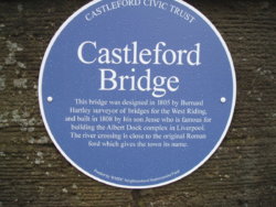
Out along Barnsdale Road, with the rider that got past me at Aire Street was in the distance, but I was slowly reeling him in
By the time we crossed the site of Allerton Bywater railway station, he wasn't far ahead, but turned off onto Newton Lane, towards Fairburn
I kept on Barnsdale, & up 'Mary Pannall' hill
https://www.pontefractandcastlefordexpress.co.uk/news/haunting-tale-of-ledston-witch-1-1223173
A right at the traffic lights took me onto the lovely back-road of Back Newton Lane, towards Ledsham, passing the
Chequers Inn & this sign outside its carpark
The Chequers used to have a 6 day licence!, see 2nd paragraph (the Church is nice too - see 4th)...…………
http://thechequersinn.com/history/
Tuesday 26th August 2008
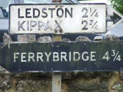
Wednesday 2nd March 2016
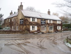
Up New Road, opposite, to pass under the 'old' (dual-carriageway-ed) A1, & then over the 'new' (motorway-ed) A1
Squires was tempting, for a brew, but it was packed!!, so onwards towards Sherburn-in-Elmet
Entering the town, the lights were against me at KirkGate, as it joins Finkle Hill (the 'Tadcaster TurnPike')
Straight over, towards the site of the Station, & the industrial estate; home to an Eddy Stobart depot, & the only (seemingly exclusively) Rolls-Royce/Bentley scrapyard that I've ever seen!!
Passing Fenton Lane, which heads to RAF Church Fenton (as was..) there's a few light aircraft up from the Sherburn Flying Club
http://www.sherburnaeroclub.com/
I've been up from here before, in a 4-seater. My best flight....ever!!!
Now it was just the long slog along BishopDike (the B1222) towards Cawood, not that far really, it just seems it, over the re-routed East Coast Main Line, at Bishop Wood (due to subsidence in the Selby Coalfields)
It was a steady run into Cawood from here, with no real reason for coming, just somewhere to go, & to have a look at the rebuilt swing-bridge, over the River Ouse
This has been covered, when the river's in flood
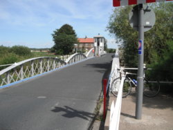 http://www.geograph.org.uk/photo/3243319
Some history here;
http://www.cawoodparishcouncil.co.uk/bridge.shtml
Once I'd had a look at it, it was on to 'Cawood Castle' (more of a GateHouse)
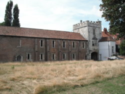
Cardinel Thomas Wolsey stayed here, & was actually arrested for Treason, in its grounds, when he couldn't get Henry 8th a 'quickie divorce'
https://en.wikipedia.org/wiki/Thomas_Wolsey#Downfall_and_death
Back along BishopDike, but with a headwind now

, as it's flat & featureless
Once back on the outskirts of Sherburn, I took the bypass, rather than head back into town (or even over to
Squires)
Heading south here, on red road;
http://www.geograph.org.uk/photo/4092441
I rejoined the (A162)
'Tadcaster TurnPike' below South Milford, & crossed the (A63) '
Selby TurnPike' at Monk Fryston, heading south towards Ferrybridge;
www.geograph.org.uk/photo/2627278
Some of the (A63) milestones even call it the 'TurnPike Road', like this;
Wednesday 11th July 2007
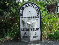
I was very pleased to see that 'an old friend', an old milestone had been repainted & the vegetation cleared, looking a lot better than this

Wednesday 23rd May 2007
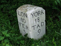
After the railway bridge was crossed at Burton Salmon, it was a short ride to Brotherton, where the
'Great North Road' converged/diverged (dependant on your direction of travel) with the
'Tadcaster TurnPike', just by the Fox pub
A drop down onto the now single carriagewayed (old) A1... which was actually the old
'GNR', as it approached Brotherton
Over the River Aire, & off at the next junction, & follow the loop round into the centre of Ferrybridge, to pass one of the old Coaching Inns ;
The Golden Lion
Friday 20th November 2015
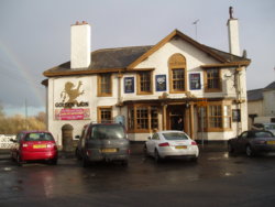
Back past the old sections of Ferrybridge Power Station, & past the new biomass powered build
Under the 'new' A1; on the road to the far right (from top - bottom)
http://www.geograph.org.uk/photo/56468
A steady climb back up to Airedale, then onto the usual roads of the area, to pass the ASDA at Glasshougton, under the M62 at Cutsyke roundabout
Along the bypass/link-road, to Havertop, & the central Custody/control room/Police Station for the area
A short stretch now along Normanton Bypass, to the roundabout at Winterton Hill, & right, to pass 'Fairways', a housing estate built where Normanton Golf Club was...
Home, & a welcome pot of tea
What will tomorrow bring?

I hope at least one person found this interesting, it makes all the typing worthwhile
EDIT; Sunday 5th @ 09:05
I actually saw the Giant rider, mentioned, again later
I was in Cawood, at the far side of the swing-bridge, & he crossed it, heading north-east, towards Kelfield
We looked at each other, as I had an equally disinctive jersey on (one of the FLAB 'Lanterne Rouge')
EDIT: Thursday 9th @ 11:15
Mapometer seems to be working again, so I've marked the route
https://gb.mapometer.com/cycling/route_4787557.html


 He uses an inexpensive old Edge 200 for navigation, but has all of his preferred data fields displayed on a Garmin Edge Touring device which he paid about £200 for. Guess which one he lost ...?


 before slowing for the corner and the bridge over the River Washburn, then the run between the hedges to the second Harrogate Road of the day.
 , stopping just before the A1(M) bridge for a final nibble.
 and onto Jewitt Lane between the hedges and passing more joggers than cyclists, before turning onto Compton Lane and climbing the dropping into Rigton Green and turning for Milner Lane and the run along the ridge towards Thorner.
 but did just as I was about to set off) and eventually out to Wetherby Road and along to Coal Road for the climb up to the roundabout, where seeing I was still short of miles, I headed out on Skeltons Lane (wind assisted, average 18mph) and then back (wind obstructed, average 13mph)


