Above the clouds: After my Bealach na Ba adventure, I couldn't leave this part of Scotland without a re-match with an old adversary of mine, the nearby Mam Ratagan Pass above Loch Duich. Some of you may recognise the name, as it featured in Claire Balding's "Britain by Bike" series that followed Harold Briercliffe's book of the same name. The road runs from Shiel Bridge, at the head of Loch Duich up and over a big lump of a mountain, reaching a height of 1,100 feet and then descending into Glenelg, from where you can proceed to Galltair to catch an unusual and very small (6 car) turntable ferry to Skye across the racing currents.
I had climbed the Mam Ratagan on my holidays twice before in previous years, always from East to West, but I had never
beaten it - by which I mean getting from bottom to top without stopping. When ridden from East to West, I think it is about 2 miles long, and the top half mile (between the two quite stunningly beautiful viewpoints) is viciously, cruelly steep -but I had managed it in stages with a few stops. I like to put new lines on the map, so this time I determined to climb it from West to East instead. This involved driving to the upper viewpoint in the car and then unloading the bike, descending down into Glenelg and going for a bit of a wander about sightseeing before finishing my exactly 20.0 mile ride with a 3 mile climb back to the car. The plan was great, but you can't always plan for the weather. We have been having quite fantastic weather in Scotland on this holiday, but today everything had disappeared under a blanket of low cloud, and visibility at the top was extremely poor - a complete whiteout with a light fret, when I arrived. Warm clothing and lights on all round were the order of the day.

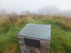
(View from the clouds)
To anyone who is interested in taking on this climb, I would urge you to do it sooner rather than later, as much of the road surface (including almost all of the 3 mile descent Westwards towards Glenelg) has recently been upgraded to lovely smooth new tarmac, and you can safely glide down the first 3 miles at speed before the road flattens out and deteriorates for the next 2 miles. There is also some lovely new tarmac on the lower reaches of the East side.
Once you get into Glenelg, you are spoilt for choice for interesting destinations, despite there being very few roads to choose from. Firstly, when you arrive in the
village of Glenelg, there are the brooding remains of the old Bernera Barracks - built to house the redcoat army just after the Jacobite Rebellion.
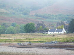
(Ruins of Bernera barracks, behind the white house).
Less than a mile along the coast to the South, there is a lovely war memorial dedicated to the Highlanders, with a backdrop of the Isle of Skye on the opposite side of the straits.
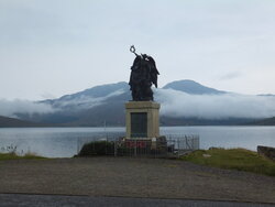
(Highlanders' Memorial)
A couple of miles further on there is a left turn up the
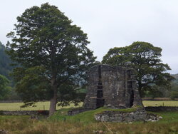
valley by the name of Glen Elg, which leads, after a few miles to a couple of interesting ruins of Pictish brocks - small fortified towers dating back to pre-Roman times in Britain (the days when Picts were Picts, and they didn't mess about with niceties like referenda). Just beyond the second of these brochs, and miles beyond the last signs of civilisation, just as I reached my turning point of exactly 10 miles from the car, I came across a small "bikes for hire" sign and a cyclists' cafe in what looked like a Mongolian yurt.

Normally I would have just
had to try this hippy cafe out, but I'd come out without any money, so I'll have to leave that to some other intrepid Cyclechatter to report back on.
.
Instead of heading back up the Mam Ratagan, you could head for the little ferry to Skye for a fantastic round trip, but there is a very long steep hill on the other side before you get to turn towards the Skye Road Bridge and a route back to Shiel Bridge via Kyle of Lochalsh and Inverinate. Alternatively, you can carry on Southwards (towards a dead end) and take in the scene of Gavin Maxwell's "Ring of Bright Water" and a load of brilliant views across to Skye and some nice little punchy climbs along the way.
After the barracks, the memorial and the brochs, I went straight back up the road to the Mam Ratagan Pass, and spent the first couple of miles trying to stop my chain from rattling and grinding. About 3 miles from the top, the road kicked up noticeably along the right flank of a hillside, and the increased pressure on the pedals seemed to make the chainset suddenly behave itself impeccably for the rest of the climb. 1,100 feet over 3 miles made this just about half the climb that I did on the Bealach na Ba, so i was determined to get up this in one go this time, and finally "beat" it.
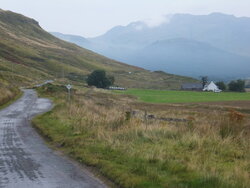
(The road to the pass, West to East)
Not much traffic today, and when I did meet a couple of trucks and half a dozen cars, the single track road was just wide enough for me not to have to stop for them. I managed to keep going, grinding my way up at somewhere between 4.5 and 5.5mph all the way to the top, keeping my breathing under control and not feeling too bad. I'll confess I would normally have given up and taken a break about a mile from the top as my backside was aching so much, and it was getting a bit steeper, but I dug deep and made it over the crest in one go, much to my own satisfaction.

Definitely easier going West to East, but still my third biggest climb to date.
Such a pity that the view from the upper viewpoint was still obscured by fog. We drove up here the other day in brilliant sunny weather, so I have included a shot of what it
can look like on a better day - great view over the end of Loch Duich and the Five Sisters of Kintail.
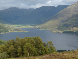
(View over Loch Duich)
Trust me, it's worth every bit of effort getting up there, whichever side you tackle. I really recommend this climb to anyone coming to this area.
Well, that's it for this holiday. back to the humdrum vale of Gloucester for me now. Cheers,
Donger.

 There is a car behind me, a lorry behind it, and I have my front light on (been one of the dark miserable days and on country lanes my black & blue top does not really stand out that well, so I play it safe and put my front light on - it was still on when I entered Middlewich), so it is not as though there is just me... right at the point where I have decided to swerve right and just let her pass down the wrong side, she vaguely starts to wander back to the other side of the road - vaguely because there is no way she is going to get there before the mini-roundabout arrives in the scene. I ended up passing here between the pavement and her car. I know her passengers had seen me... I have no idea what the car behind me did, but I had a good gap for a while before any other vehicles actually caught me up!


 There is a car behind me, a lorry behind it, and I have my front light on (been one of the dark miserable days and on country lanes my black & blue top does not really stand out that well, so I play it safe and put my front light on - it was still on when I entered Middlewich), so it is not as though there is just me... right at the point where I have decided to swerve right and just let her pass down the wrong side, she vaguely starts to wander back to the other side of the road - vaguely because there is no way she is going to get there before the mini-roundabout arrives in the scene. I ended up passing here between the pavement and her car. I know her passengers had seen me... I have no idea what the car behind me did, but I had a good gap for a while before any other vehicles actually caught me up!


 The ride in felt brilliant; my legs seemed full of energy despite it being Friday and everyone else on the road behaved. I think it was my quickest of the week too, which set me thinking about getting some easier rolling tyres if this was to become a regular thing.
 It did rain pretty well while I was working, leaving behind a misty and drizzly afternoon, so the lights got some use on the way back. I was going to try the short route home as I was about 20 minutes late setting out, but with the misty conditions it seemed like a better idea to retrace the scenic morning route even if it is a couple of miles longer.


 Normally I would have just had to try this hippy cafe out, but I'd come out without any money, so I'll have to leave that to some other intrepid Cyclechatter to report back on.

 Definitely easier going West to East, but still my third biggest climb to date.


 We're not worthy!