Your bike in front of something different...

Page may contain affiliate links. Please see terms for details.
Church of St John The Evangelist
Jackson Lane (just off the 'Great North Road')
WentBridge

Described, as a 'Mort-Safe' in some areas, & a Sextons shed in others
Maybe the former use, became the latter?

https://britishlistedbuildings.co.u...t-john-the-evangelist-darrington#.W7TGYPZFzIU
http://www.geograph.org.uk/photo/228779
http://www.geograph.org.uk/photo/3351538


DSCF6882.JPG


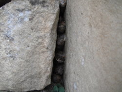
Snails, in the stonework, by my 'bars
DSCF6883.JPG


EDIT @ 21:49

It seems a suitable explanation

The Church is a bit out of the way, & close to the 'Great North Road' ready for transportation of a body to any Surgeon/Anatomist willing to pay?

https://en.wikipedia.org/wiki/Mortsafe#Vaults_and_watch-houses
 
Last edited:

ColinJ

Puzzle game procrastinator!
Here's a varied selection for you. My bike in front of ...

... stone sheep!

stone_sheep_mankinholes.jpg


... a landslip caused by local floods. Bonus points for the fact that the land happened to have an old asbestos waste tip at the top of it! :eek:

Scout Rd reopened.jpg


... more flood damage, a mile across the valley - where's my retaining wall!

Ok who stole my retaining wall.jpg


... jammed lift doors at Bradford Interchange railway station. I spent many happy minutes in there! :laugh:

Jammed lift - with bike.jpg
 
Last edited:
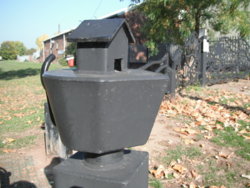
'Whitwood Mere' (as the area is known)
Methley Road
Castleford
Road-Trip. 67.JPG

There's a series of them, on posts by the railings alongside the low-lying field there

It's approximately where the 'red arrow' is; https://www.geograph.org.uk/photo/663161


They are barges, or tug-boats, alluding to the 'Tom Puddings' that were worked up & down the River Aire, at this point;

If you scroll down into the black & white pictures, there's some of the 'Toms'; https://www.stanleyhistoryonline.com/Ferry-Lane-Photos.html

Also; https://www.waterwaysmuseum.org.uk/blog-1/the-golden-age-of-tom-puddings
DSCF6925.JPG

 
Top Bottom