Show us your.......newbie progress! [4 Sep 2012 - 4 Oct 2014]

Status
Not open for further replies.
Page may contain affiliate links. Please see terms for details.
We are currently staying to the North of Hastings in the South Downs
Did a hilly ride today
http://www.strava.com/activities/133452656
28.6 miles at only12.7 mph, a hilly route with 2408 feet of climbing, some tough hills with real gradients in places

Brede hill was the toughest, was a little to agressive and needed to pause (Edit it was 9.0 %)
The terrain takes a bit of getting used to for me
 
Last edited:
Location
Pontefract
 
Location
Pontefract
We are currently staying to the North of Hastings in the South Downs
Did a hilly ride today
http://www.strava.com/activities/133452656
28.6 miles at only12.7 mph, a hilly route with 2408 feet of climbing, some tough hills with real gradients in places

Brede hill was the toughest, was a little to agressive and needed to pause (Edit it was 9.0 %)
The terrain takes a bit of getting used to for me
84.2ft/mile I would be chuffed at 12.7mph.

This peaks about 10% but its not very long but has a long lead in to it, so you lose a lot of momentum
http://app.strava.com/activities/133460393/segments/3023973941
 
Location
Pontefract
Looks good. Do you know when it will go live and if it will be for non premium members.
You can access it through veloviewer by clicking on the double arrow icon
Capture.JPG

So if you dont use veloviewer now is a good time to start, it links with your strava data, but shows a lot more info

upload_2014-4-24_7-41-5.png


Thats just the ride info it goes much deep in information, including segments.
 
Last edited:
Location
Pontefract
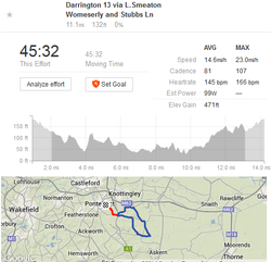
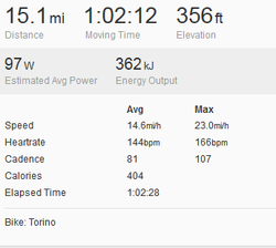
Just to show you how wrong strava is on elevation if left to its own correction, the following 13 mile segment had an elevation gain of 471 ft, for the whole 15 mile ride strava gives it as 356ft

upload_2014-4-24_9-7-34.png

The whole ride.
upload_2014-4-24_9-10-43.png
and there was about another 40-60ft or so, which would put it much closer to the figure of 520ft I get on RWGPS
 

Venod

Eh up
Location
Yorkshire
Just to show you how wrong strava is on elevation if left to its own correction, the following 13 mile segment had an elevation gain of 471 ft, for the whole 15 mile ride strava gives it as 356ft

View attachment 43277

The whole ride.
View attachment 43278
and there was about another 40-60ft or so, which would put it much closer to the figure of 520ft I get on RWGPS

Nigel, I have been following your discussion re elevation gain,of all the different results, which is the most accurate ?

I have Memory Map on the computer which uses ordnance survey mapping, so I drew this route and looked at the elevation gain it is 472ft in memory map which is near enough your 471ft, was 471ft from your GPS ?

My watch does not do elevation so whatever Strava says is all I have.
 
Location
Pontefract
Nigel, I have been following your discussion re elevation gain,of all the different results, which is the most accurate ?

I have Memory Map on the computer which uses ordnance survey mapping, so I drew this route and looked at the elevation gain it is 472ft in memory map which is near enough your 471ft, was 471ft from your GPS ?

My watch does not do elevation so whatever Strava says is all I have.
The 471ft is what strava reported for the segment, rwgps gives 425 but strava for the whole ride only gave 356ft so something is wrong with strava, in a unit that measures using a barometer and this is left uncorrected on strava, it will show what is in the relevant sections of the file i.e. if the units shows in the summary 460ft that is what strava will show, however in units like the rider 20 and garmin 200 they dont have this feature and have to take the elevation from gps plots, and usually for a whole ride strava can cost you about 30-40% (you should see my elevation plots straight from the unit just one long liner line I can shoe up to 7,000ft on a flat ride of 30 miles or so), so basically I wouldn't put much faith in the overall elevation on strava, rwgps was always closer when I had the 500 so I use that, and for consistency between rides.
 

Mo1959

Legendary Member
@Nigelnaturist Even the device used seems to make quite a big difference sometimes. I was looking at a ride a father and son over near me did together so exactly the same ride as they stuck together for the whole route. The father used a 705 and it recorded 6,280ft and the son used an Edge 200 which recorded 5,727ft. Quite a big difference really. I use the 200 and sometimes feel I get cheated out of elevation with it. Maybe the ones with the altimeters are more accurate? Not sure.
 
Location
Pontefract
@Nigelnaturist Even the device used seems to make quite a big difference sometimes. I was looking at a ride a father and son over near me did together so exactly the same ride as they stuck together for the whole route. The father used a 705 and it recorded 6,280ft and the son used an Edge 200 which recorded 5,727ft. Quite a big difference really. I use the 200 and sometimes feel I get cheated out of elevation with it. Maybe the ones with the altimeters are more accurate? Not sure.
The 705 uses a barometer to measure gain/loss however they need to be set (the 500 had 5 or 10 I can't remember, that you could set, and when you started recording if close to one it would set that as the elevation) to recorded the actual elevation height, though relatively gain/loss would be still right, the other problem is the barometer is effected by the heat of the unit, it therefore needs to be allowed to reach the ambient temp, and even then they can show (usually a loss) of upto 60ft or so i.e. my home elevation is about 172ft many a time using the 500 (and the rider 35) the end elevation may be 153ft, nothing is perfect, even two identical units on the same bike could give different results, though they should be minimal.
I also found if I corrected the fit file on rwgps, it would a lot of anomalous peaks/troughs, I will wait till I get a 705, to see if the same happens, as it may be a fault in conversion from the fit format. The 200 and Rider 20 have to take elevation from gps plots the software uses (as do many other units no doubt).
 
Status
Not open for further replies.
Top Bottom