You are using an out of date browser. It may not display this or other websites correctly.
You should upgrade or use an alternative browser.
You should upgrade or use an alternative browser.
My picture of the day-Where's yours?
- Thread starter bigjim
- Start date
Page may contain affiliate links. Please see terms for details.
Thorn Sherpa
Über Member
- Location
- Doncaster
Market place at Doncaster on the way back from work
briantrumpet
Legendary Member
- Location
- Devon & Die
Apologies, second one of the day, but I enjoyed some chilled beer tonight at one of the country's best pubs. Fortunately it's just a five-minute ride from home.

Elysian_Roads
Senior Member
Are they all your empties, @briantrumpet? Ps love your photos, keep them coming.Apologies, second one of the day, but I enjoyed some chilled beer tonight at one of the country's best pubs. Fortunately it's just a five-minute ride from home.
View attachment 400722
briantrumpet
Legendary Member
- Location
- Devon & Die
Yes, empties, but it wasn't me who drank their contents. I merely helped out a little with another barrel tonight.Are they all your empties, @briantrumpet? Ps love your photos, keep them coming.
In case you're wondering, it's The Bridge Inn at Topsham. Well worth a visit.
Elysian_Roads
Senior Member
If I'm ever down that part of the world, will be sure to give it a try. Cheers!Yes, empties, but it wasn't me who drank their contents. I merely helped out a little with another barrel tonight.
In case you're wondering, it's The Bridge Inn at Topsham. Well worth a visit.
Was curious about the "insurgent country" singer playing there. That is a musical genre that has passed me by....
briantrumpet
Legendary Member
- Location
- Devon & Die
Occasionally locals Steve Knightley and Phil Beer (aka Show Of Hands) do a gig here... rather amusing, as they can pack the Royal Albert Hall when they choose to play in London.If I'm ever down that part of the world, will be sure to give it a try. Cheers!
Was curious about the "insurgent country" singer playing there. That is a musical genre that has passed me by....
Richard A Thackeray
Legendary Member
Out & about today, just 'pottering' really
'Caleb Crowthers Almhouses'
George Street
Wakefield
http://www.geograph.org.uk/photo/660612
Built for (chosen) poor who worshipped here; http://www.geograph.org.uk/photo/660615
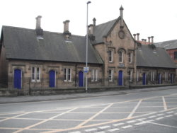
There's another Crowthers Almshouses in Ackworth, but attributed to a Mary
I have no idea if any family connection?
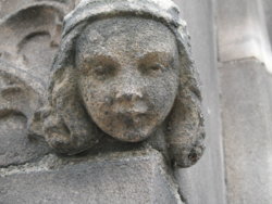
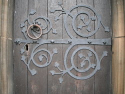
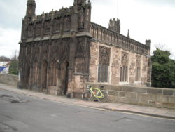
'Chantry Chapel'
(officially; Saint Mary On The Bridge)
One of only 4 remaining Bridge Chapels in the country
http://www.geograph.org.uk/photo/1518305
EDIT @ 14:54
I've just checked my old photo-files, & the Ackworth Almshouses are 'Lowthers', not 'Crowthers'
Easy mistake...............
'Caleb Crowthers Almhouses'
George Street
Wakefield
http://www.geograph.org.uk/photo/660612
Built for (chosen) poor who worshipped here; http://www.geograph.org.uk/photo/660615

There's another Crowthers Almshouses in Ackworth, but attributed to a Mary
I have no idea if any family connection?
'Chantry Chapel'
(officially; Saint Mary On The Bridge)
One of only 4 remaining Bridge Chapels in the country
http://www.geograph.org.uk/photo/1518305


I first heard them on the 'Radcliffe & Maconie Show', when they guested during Mark & Stuarts 'Jurassic Coast Walk' (a mixture of live & recorded broadcast)Occasionally locals Steve Knightley and Phil Beer (aka Show Of Hands) do a gig here... rather amusing, as they can pack the Royal Albert Hall when they choose to play in London.
EDIT @ 14:54
I've just checked my old photo-files, & the Ackworth Almshouses are 'Lowthers', not 'Crowthers'
Easy mistake...............
Last edited:
briantrumpet
Legendary Member
- Location
- Devon & Die
More Topsham...

Richard A Thackeray
Legendary Member
Just a local 'potter' again, today
Out on the CGR, as I knew I'd be venturing onto tow-paths
After heading out of town, I utilised a very short section of the 'Wakefield Wheel', from Station Road, to Altofts Hall Road, by heading in a northerly direction here; http://www.geograph.org.uk/photo/1405344
Once in Altofts, it was past St Marys Church (where we got married) & a right turn, down Foxholes Lane to the Aire & Calder Navigation Canal
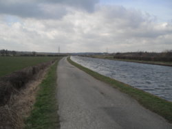
Towpath/Birkwood Lock access road
Looking in opposite direction; http://www.geograph.org.uk/photo/509906
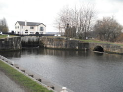
Birkwood Lock
A substantial stone-constructed culvert that runs under Canal, adjacent to the Birkwood Road bridge, over the Canal
Under this parapet; http://www.geograph.org.uk/photo/1843521
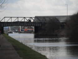
Birkwood Road Bridge
My commute-route to work crosses it
http://www.geograph.org.uk/photo/1401303
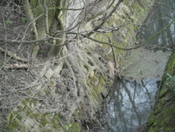
A marker stone by the bridge
I'm not sure what the '29' signifies
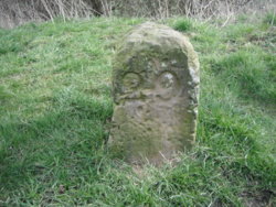
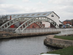
The two Aquaducts
The bow-bridge is the older, & dates to 1839
Grade 1 listing too
http://www.geograph.org.uk/photo/827597
https://www.britishlistedbuildings.co.uk/101261690-stanley-ferry-aqueduct-normanton
Out on the CGR, as I knew I'd be venturing onto tow-paths
After heading out of town, I utilised a very short section of the 'Wakefield Wheel', from Station Road, to Altofts Hall Road, by heading in a northerly direction here; http://www.geograph.org.uk/photo/1405344
Once in Altofts, it was past St Marys Church (where we got married) & a right turn, down Foxholes Lane to the Aire & Calder Navigation Canal
Towpath/Birkwood Lock access road
Looking in opposite direction; http://www.geograph.org.uk/photo/509906

Birkwood Lock

A substantial stone-constructed culvert that runs under Canal, adjacent to the Birkwood Road bridge, over the Canal
Under this parapet; http://www.geograph.org.uk/photo/1843521

Birkwood Road Bridge
My commute-route to work crosses it
http://www.geograph.org.uk/photo/1401303

A marker stone by the bridge
I'm not sure what the '29' signifies

The two Aquaducts
The bow-bridge is the older, & dates to 1839
Grade 1 listing too
http://www.geograph.org.uk/photo/827597
https://www.britishlistedbuildings.co.uk/101261690-stanley-ferry-aqueduct-normanton

Last edited:
Mojonaut
Guru
- Location
- Nr Kettering, Northants
Out on the roadie, first springlike day for a while, still a nasty old wind but lovely to see blue skies and mostly unbroken sunshine.
BT's Morborne Hill radio mast (the concrete one) that's a separate lattice tower behind it. (Cambridgeshire).

BT's Morborne Hill radio mast (the concrete one) that's a separate lattice tower behind it. (Cambridgeshire).
Mojonaut
Guru
- Location
- Nr Kettering, Northants
Same ride as tower photo above, along the way I met Mike Dooley out near Lutton and The Giddings (Cambs), rode alongside and had a chat, found he was cycling from Middlesbrough to Australia!
He has a Facebook page for anyone interested in his progress.
https://www.facebook.com/Wheres-Dools-2000063056702458/

He has a Facebook page for anyone interested in his progress.
https://www.facebook.com/Wheres-Dools-2000063056702458/
Salty seadog
Space Cadet...(3rd Class...)
Whitstable harbour today.

A narrow alley.

Apparently they don't sell beer....

A narrow alley.
Apparently they don't sell beer....
swee'pea99
Squire
Don't look now, but I think it might be spring at last....

Similar threads
- Replies
- 12

