You are using an out of date browser. It may not display this or other websites correctly.
You should upgrade or use an alternative browser.
You should upgrade or use an alternative browser.
Game: Name that road!
- Thread starter ColinJ
- Start date
Page may contain affiliate links. Please see terms for details.
ColinJ
Puzzle game procrastinator!
- Location
- Todmorden - Yorks/Lancs border
I was thinking it was high because those look like snow poles...
I don't know how I missed that one! I was looking in that area but somehow didn't even notice that road. I probably got distracted by my Zoom call which went on for longer then expected.Correct! Swinhope Head. Joint highest pass in the Pennines and thus presumably the highest pass (as distinct from just a road up and back) in England, at 609m.
Definitely to be avoided...!The last time I went over that a cloudburst electrical storm started as I came over the top, heading southwards. Seriously scary as there was forked lightning striking every few seconds and there's very little up there that's higher than 'person on a bike'. The road was stream-like and I was balancing the risk of being hit by lightning with the risk of crashing due to going down too fast. Both events avoided, fortunately.
I nearly got caught out once on the climb from Oxenhope back over to Hebden Bridge but I saw the storm blowing in and took shelter in the railway station in Oxenhope. I saw scores of lightning bolts zapping the hillside either side of the road that I would have been riding up!
Once the storm blew over, I did the climb and found that the deluge had made an underground stream swell to the extent that it had burst through the road surface and created a fountain in the middle of the road!
It gave me a healthy respect for lightning, as did ...
- A young man being hit by lightning in front of my sister's local shops. He survived but suffered serious burns.
- A group of teenagers being hit by wood shrapnel from a tree which exploded when hit by lightning as they sheltered beneath it in a storm in my dad's home town.
- My dad telling me that he had seen a herd of cows killed by a bolt of lightning which struck the ground between them.

swansonj
Guru
Time for a clue?Next entry. My previous hairpin bend lasted just five hours, let's see what happens with this one...
View attachment 574344
This always looks a bit like the second hairpin up Box Hill to me:
[edit to avoid any possible ambiguity: that is a picture of the Box Hill hairpin not my entry in this thread]
But, whereas this climb starts at a similar altitude as Box Hill does, it ends up slightly over twice as high as Box Hill.
There's another comparison to Box Hill that I could draw, but I'll save that for a later clue if needed.
Last edited:
swansonj
Guru
I was counting Box Hill as starting at the Burford Bridge hotel, so slightly lower than your figure, and my use of "slightly" as in "slightly over" may be a bit more generous than yours ... but broadly, yes....Goes to OS map and gets out calculator ...
It starts at an altitude similar to 60m (ish). It ends up slightly over 344m.
roubaixtuesday
self serving virtue signaller
I was counting Box Hill as starting at the Burford Bridge hotel, so slightly lower than your figure, and my use of "slightly" as in "slightly over" may be a bit more generous than yours ... but broadly, yes....
Well, I took one look and thought "Sothern England" - but the height suggests otherwise.
swansonj
Guru
Well, you certainly won't find a climb of those specifications in the south-east😀Well, I took one look and thought "Sothern England" - but the height suggests otherwise.
swansonj
Guru
I don't want to patronise anyone, but just to make sure it doesn't get missed, here's that last clue with extra emphasis:
Well, you certainly won't find a climb of those specifications in the south-east😀
Sea of vapours
Guru
- Location
- Clapham, Yorkshire Dales
Is it Stock Hill, north side of Exmoor?
https://tinyurl.com/y8ej45nb
I'm not wholly convinced, but it looks very similar and I couldn't think of anywhere in the south with that start and end point altitude.

https://tinyurl.com/y8ej45nb
I'm not wholly convinced, but it looks very similar and I couldn't think of anywhere in the south with that start and end point altitude.
Last edited:
Aravis
Putrid Donut
- Location
- Gloucester
I'm not 100% sure, but it might be New Road, the southernmost of the two toll roads providing a "sensible" alternative to Porlock Hill:

Last edited:
Sea of vapours
Guru
- Location
- Clapham, Yorkshire Dales
I was about to post New Road as an alternative, though the trees in the background look different.
https://tinyurl.com/y9s5fqna
https://tinyurl.com/y9s5fqna
Aravis
Putrid Donut
- Location
- Gloucester
I thought the same initially, but I'm growing a little more (guardedly) confident. The Google image is from 2014, so there might've been time for the trees behind to thicken up a bit. Also the roadworks scar in the middle seems to match.I was about to post New Road as an alternative, though the trees in the background look different.
https://tinyurl.com/y9s5fqna
We should know soon!
ColinJ
Puzzle game procrastinator!
- Location
- Todmorden - Yorks/Lancs border
If you are right then that explains why it looked a bit familiar - I used Street View to go up and down that climb (comparing it to the steep A-road) only about a month ago. My younger sister has moved to Devon so I have been looking at routes for future post-pandemic Devon forum rides!I'm not 100% sure, but it might be New Road, the southernmost of the two toll roads providing a "sensible" alternative to Porlock Hill:
View attachment 574936
PS I hadn't noticed that there are 2 toll roads. I will Street View the other one too.
Last edited:
swansonj
Guru
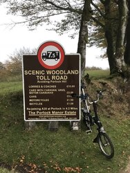
Yup, New Road aka Porlock Hill toll road. Well done. My photo was 2018.I thought the same initially, but I'm growing a little more (guardedly) confident. The Google image is from 2014, so there might've been time for the trees behind to thicken up a bit. Also the roadworks scar in the middle seems to match.
We should know soon!

It was built from scratch to provide an alternative to the A road, so was built at a pretty uniform gradient, which makes it a joy to cycle, even on a Brompton. The cycle toll is, from memory, one quid, and coming down, you don't really need to stop at the toll booth, just slow enough to toss your pound coin over as you go past.
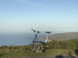
I agree with others who have commented that it's rare to able to start that near sea level and be able to go straight up to 400 m. This was the view from the top on that particular evening:

Over to you.
Last edited:
swansonj
Guru
I predict that if you do the climb first on the toll road, it will create an itch that will eventually force you to scratch it by doing it again up the A road.If you are right then that explains why it looked a bit familiar - I used Street View to go up and down that climb (comparing it to the steep A-road) only about a month ago. My younger sister has moved to Devon so I have been looking at routes for future post-pandemic Devon forum rides!
PS I hadn't noticed that there are 2 toll roads. I will Street View the other one too.
