livpoksoc
Guru
- Location
- Basingstoke
Just been out on a ride I plotted out using Ridewithgps, loaded to my edge 200 as a course.
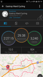
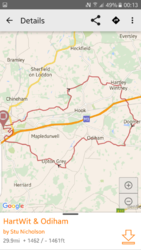
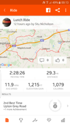
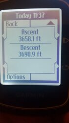
It's a simple 29 mile ride on country lanes. No huge climbs, some undulation but nothing major, yet when I review the ride there are some discrepancies between the devices/sites. Given that all the sites use Google Maps, I am unsure how this happens.
Ridewithgps = 1462ft
Strava = 1215ft
Garmin Connect = 924ft
Garmin Edge 200 device = 3658.1ft
Over a 30 mile route that's some big differences. Does anyone have an answer to this as I am not sure I can trust the Edge device, but even still Garmin's connect app hasn't taken the device at face value but still makes it 66% of both RWGPS and Strava.
Anyone got a clue why this may be?