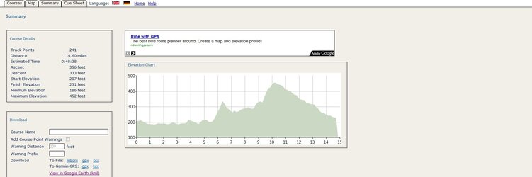
Any chance of a gradient profile?
I'm looking for an online tool to do gradient profiles from GPX files - do you know of one? I use Memory Map for plotting routes and it only does altitude and speed profiles.
It's the kind of tool I wouldn't mind trying to develop if there isn't a good one available. The problem would be getting access to the altitude data but there's probably some way of fishing it out of Google Maps.
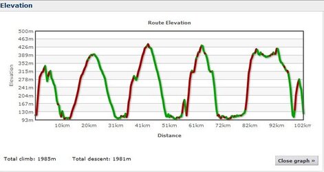
Is that a 12% straight out of the blocks?
Unfortunately, pretty much so, yes! The ride starts from near the Co-op in Hebden Bridge, and the hill is the Heptonstall Road which starts about 200 m down the A646 towards Todmorden.
I only live a few minutes from the start so I don't get a warm-up riding to the start and there is no warm-up
after the start before the hill! The event takes place the first weekend in October and it is always cold in the valley at that time of year at that time of day so it is literally staight from a very cold start to a pretty tough climb.
The first time, I did it with no warm-up and hardly made it up the hill and felt like throwing up when I got to the top. Now, I ride up and down the valley for 15 minutes or so first just to get my legs working. I also get up early to make sure that my breakfast is settled before I start riding!