CC Jodrell Bank Run Spring 2012 - SUNDAY 22nd April

Page may contain affiliate links. Please see terms for details.

potsy

Rambler
Location
My Armchair
Potsy - a good way of checking your download would be to upload it back to MapMyRide and zoom in to make sure that it follows the entire route properly. If it does, you are okay. When I did this for the flat century ride file, it was very obvious that alternate points had been discarded. If it doesn't look right, tell me what GPS you have and I'll look up what its limits are and work out a solution for you.
Cheers Col, I'll have a look later or tomorrow.
It's a Garmin 605 btw, I assume Fossy has just downloaded the route to his 705(?) as it is?

ps How have you found out the track point data? How many etc?
 

potsy

Rambler
Location
My Armchair
Guys I'll load into my garmin mapsource and double check it later.
:cheers:
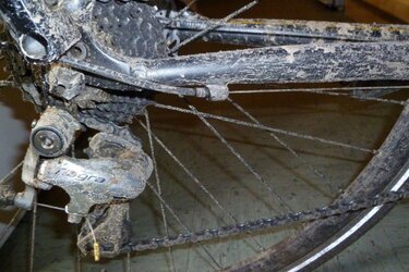
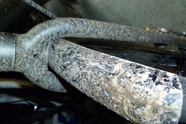
Btw, is there a cleanliness standard for the ride? Will I have to clean my bike for it? :tongue:
Dirt3.jpg Dirt1.jpg
 
OP
OP
fossyant

fossyant

Ride It Like You Stole It!
Location
South Manchester
BTW the Map my ride produced 10k track points - you used to have an opportunity to reduce that, but it's been buggered about with. Which mapping is everyone using ? - I usually just use Garmin Mapsource these days.

I no doubt the map would have loaded to the 705, but it would have fell over trying to 'navigate it'.
 

potsy

Rambler
Location
My Armchair
Getting more confused now (it doesn't take a lot) as I have downloaded both your links and tried them.
The original (10,000 tp's) takes an age to load but does eventually start navigating.
The one with less tp's loads much quicker but appears to have cut out nearly 8 miles of the route???
65 miles compared with 57.3???????

Help :surrender:

I think this was the problem on Colin's last ride, my Garmin was taking ages to load the route so I thought it was broken, would probably have started navigating if I'd given it a bit longer :unsure:
 
OP
OP
fossyant

fossyant

Ride It Like You Stole It!
Location
South Manchester
I shall re check !!

Right, exact same route -

Looks like Map my ride is inaccurate - just double checked uploading to my 705 using citynav 2012.4 NT maps.

Oh well 30 miles to lunch - we'll be in time for the breakfast menu !
 

ColinJ

Puzzle game procrastinator!
Cheers Col, I'll have a look later or tomorrow.
It's a Garmin 605 btw, I assume Fossy has just downloaded the route to his 705(?) as it is?

ps How have you found out the track point data? How many etc?
My Memory Map software has a properties dialog which tells me that it has 10,627 trackpoints.

There is a 'Reduce' button on that dialog which discards alternate trackpoints when clicked. That's a dumb way of doing the reduction because it keeps trackpoints where they are not needed (for example on a long stretch of nearly straight road) but discards them where they might be needed (for example a left turn followed by an immediate right or vice versa). It is a very easy thing to program so that's why they did it that way.

I clicked 'Reduce' 4 times to get the number of trackpoints down to 1,330. That still gave a pretty good approximation to the underlying roads but another reduction to 665 trackpoints was too much, given the dumb way in which it is done. I'm sure that the route could be represented quite nicely by (say) 250 trackpoints if trackpoints were carefully chosen to fit in with all the junctions and roundabouts and the spare points used to fill in long sections between those points.

I've looked up the spec. for the 605 and it apparently can store 21 tracks of upto 500 trackpoints each, so you should find that it choked on the 10,627 trackpoints of the unsimplified GPX file if you look at it closely.

I've just gone through the route and manually reduced it to 361 trackpoints but tried to make sure all the turns are still accurately marked. I'll upload it to MMR later and check it there because Memory Map's Landranger OS mapping isn't accurate for roads in towns and cities.
 

ColinJ

Puzzle game procrastinator!
Looks like it's time to ditch map my ride !
I usually use Bikely so I'll post my simplified file there as well as MMR, but I need to have something to eat first.

I clock the route at about 65 miles (105 km).

PS Potsy, Svendo and others have complained about problems with my route files on Bikely so I think this trackpoint limit has been catching people out.
 
Top Bottom