G-Zero
Guru
- Location
- Kirkcudbright, SW Scotland
Teething troubles ??
After this morning's trail ride, these are the figures that Cyclemeter ended up with and the figures pose several questions.
(RIDE TIME = 2.50.07) (STOPPED TIME = 13.08 Mins) (DISTANCE = 32.78 Miles)
(SPEED = 10.77) (AV.SPEED = 11.56) (FASTEST SPEED = 12.40)
(ASCENT = 1146FT) (DESCENT = 1078FT) (CALORIES = 4633)
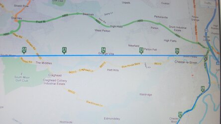
1) (Distance = 32.78) The route I rode is actually 4 miles longer than the distance above (Memorymap OS 1:50000) but on checking the route map there are a few locations shown as being 'straightlined', the worst between 20 and 27 miles (see pic), where the actual route is further to the north and not straight. This explains the missing miles, but is it likely to be a signal or GPS shadow problem ?. Phone is in a thin pocket at the top of my Camelbak hydration rucsac. Am I going to have to get a waterproof bar mount ?
2) (Fastest speed = 12.40) On a couple of downhill road sections my computer briefly showed speed in excess of 30mph and there are a couple of long downhills on the trail where I maintained in excess of 20mph for a good couple of miles.
3) (Average speed = 11.56) 37 miles in 3 hours should be a tad over 12mph average.
4) (Stopped time = 13.08) Stopped for a couple of gates and to allow cars to pass before crossing roads. I didn't time the stops, but a guessing a max of 2 or 3 minutes. Does the system have a minimum speed where it classes anything below that as a stop ie, crawling past loose dogs, crossing roads etc.
5) (Calories = 4633) Really ?
After this morning's trail ride, these are the figures that Cyclemeter ended up with and the figures pose several questions.
(RIDE TIME = 2.50.07) (STOPPED TIME = 13.08 Mins) (DISTANCE = 32.78 Miles)
(SPEED = 10.77) (AV.SPEED = 11.56) (FASTEST SPEED = 12.40)
(ASCENT = 1146FT) (DESCENT = 1078FT) (CALORIES = 4633)
1) (Distance = 32.78) The route I rode is actually 4 miles longer than the distance above (Memorymap OS 1:50000) but on checking the route map there are a few locations shown as being 'straightlined', the worst between 20 and 27 miles (see pic), where the actual route is further to the north and not straight. This explains the missing miles, but is it likely to be a signal or GPS shadow problem ?. Phone is in a thin pocket at the top of my Camelbak hydration rucsac. Am I going to have to get a waterproof bar mount ?
2) (Fastest speed = 12.40) On a couple of downhill road sections my computer briefly showed speed in excess of 30mph and there are a couple of long downhills on the trail where I maintained in excess of 20mph for a good couple of miles.
3) (Average speed = 11.56) 37 miles in 3 hours should be a tad over 12mph average.
4) (Stopped time = 13.08) Stopped for a couple of gates and to allow cars to pass before crossing roads. I didn't time the stops, but a guessing a max of 2 or 3 minutes. Does the system have a minimum speed where it classes anything below that as a stop ie, crawling past loose dogs, crossing roads etc.
5) (Calories = 4633) Really ?