Found this in google earth and thought it might be of some interest to people here.
1. Go to options and set terrain exaggeration to 3
2. Draw a path in google earth or download the .kml file from a website like ridewithgps
3. Open it in google earth, right click on the path in the sidebar and select show elevation profile
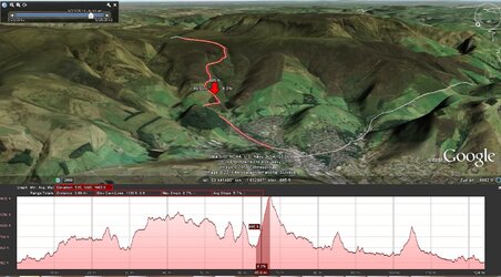
And then you get a very detailed idea of what it will be like. I found what looks like a cracking downhill near Glossop.
1. Go to options and set terrain exaggeration to 3
2. Draw a path in google earth or download the .kml file from a website like ridewithgps
3. Open it in google earth, right click on the path in the sidebar and select show elevation profile
And then you get a very detailed idea of what it will be like. I found what looks like a cracking downhill near Glossop.