alci4
Well-Known Member
- Location
- birmingham
hi folks had the edge 705 for crimbo and love it but would like to pick the brains of the more knowledgable (than me) on the forum please
firstly doing my daily commute which on the edge normally comes in at just under ten miles but today i set the data recording settings to every second thinking that it would be more accurate but today my commute came in at 7.6 miles and i got no idea why as the map shows exactly the same route as every other day
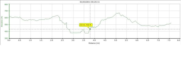
secondly looking at my elevation graph setting off from home my elevation is 620ft but arriving home 7.5 (or 10) miles later my elevation at home was 517ft. graph jpeg below.
Am i missing somthing that will explain this or is my edge faulty
thanks for any help
firstly doing my daily commute which on the edge normally comes in at just under ten miles but today i set the data recording settings to every second thinking that it would be more accurate but today my commute came in at 7.6 miles and i got no idea why as the map shows exactly the same route as every other day
secondly looking at my elevation graph setting off from home my elevation is 620ft but arriving home 7.5 (or 10) miles later my elevation at home was 517ft. graph jpeg below.
Am i missing somthing that will explain this or is my edge faulty
thanks for any help