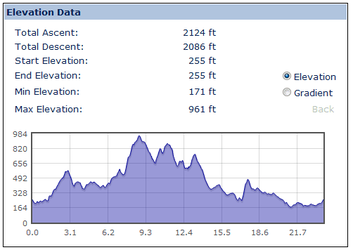
Easiest way to find out the height gain on my ride?

Page may contain affiliate links. Please see terms for details.

Globalti

Legendary Member
Short of sitting and laboriously counting contour lines and spot heights off the map, is there an easy way of computing the height gain over my ride? I've got an altimeter watch but don't think that can record for more than a couple of hours. Is there any online site or software that I don't actually need to download onto the laptop? It's a work laptop so we're not supposed to download any software without permission from the IT department.
 

cyberknight

As long as I breathe, I attack.
I used to use

http://bikehike.co.uk/index.php

Plot your route and it should tell you .
 

albion

Guru
As above but just buy the £20 Pulse Mini mentioned in the bargain thread.

6 month internet means you can even bypass the wifi or USB connection to a PC.

Endomono and Mytracks and probably dozens more do the same.
 

coffeejo

Ælfrēd
Location
West Somerset
I used to use

http://bikehike.co.uk/index.php

Plot your route and it should tell you .

Meep: scary stuff.

meep.png
 

albion

Guru
5 hours standard for the free Endomondo app. Certainly 10 , maybe even 12 hours underclocked and in flight mode.
 
5 hours standard for the free Endomondo app. Certainly 10 , maybe even 12 hours underclocked and in flight mode.


I might have to have a go at that. My TomTom One's battery only lasts about 3 hours, even with the screen switched off :sad:

Do you need some kind of handlebar mount for the Pulse Mini to make sure it can 'see' the satellites, or will it work from inside a pocket, or bag?
 
Just another site but I quite like ridewithgps :smile:
 

albion

Guru
5 hours is with the screen switched off. Not sure what screen on is like but its less than average in sunlight anyway. I've also a 4xAA USB supply if I decide to bike to places more unknown.
 

briantrumpet

Legendary Member
Location
Devon & Die
I used to use

http://bikehike.co.uk/index.php

Plot your route and it should tell you .
... though with the caveat that all the sites that use Googlemaps for working this out seem to underestimate (sometimes by a considerable margin) the amount of climbing, thanks to the low resolution of elevation data that Googlemaps uses. I think if you can use Google Earth, or a program like Mapyx Quo, you'll get much more accurate figures, if these things are important to you.
 

itchyrider

Aka Chris
Location
london N16
This one you dont need gps unit of any sort just use mapmyfitness draw your route and it tells you when you press the altitude or elevation.
 
OP
OP
Globalti

Globalti

Legendary Member
Map My Fitness is the same as Map My Ride. I got on OK with Bikehike because you don't need to join. The eventual distance figure was two miles less than my bike computer measured so that's close enough for me over 55 miles.
 

soulful dog

Veteran
Location
Glasgow
As above but just buy the £20 Pulse Mini mentioned in the bargain thread.

6 month internet means you can even bypass the wifi or USB connection to a PC.
Endomono and Mytracks and probably dozens more do the same.

At that price as long as you don't mind seeing how many miles you've done, how fast you're going etc during your ride, that's got to be worth considering instead of a bike computer is it not?
 

Hacienda71

Mancunian in self imposed exile in leafy Cheshire
Endomondo logs altitude and is web based, but you will need some form of gps type device to use it. A smart phone being the simplest.
 
Top Bottom