Distance planning

Page may contain affiliate links. Please see terms for details.

Enw.nigel

Well-Known Member
Location
Cardiff
Is there a website out there that is really good for route planning? I have used 'mapmyride.com' but sometimes find the route jumps to roads that I do not want to use. Seems to be a problem on a certain dual carriageway/overpass that I use. Doesn't matter how much I magnify the road system. Also used' cycle-route.com' which does not have this problem. Are there any others i should be looking at?
Many thanks
 
I use ridewithgps, all mapping sites I've found however do tend to use d/c's etc if you click too far apart but you can zoom in to rectify that, another thing you sometimes have to do at contraflow or one way street changes, is select the 'draw lines' button to override things. RWGPS also has an option for walking or cycling mode but at the moment it is limited to the US :sad:
 

calibanzwei

Well-Known Member
Location
Warrington
I use ridewithgps, all mapping sites I've found however do tend to use d/c's etc if you click too far apart but you can zoom in to rectify that, another thing you sometimes have to do at contraflow or one way street changes, is select the 'draw lines' button to override things. RWGPS also has an option for walking or cycling mode but at the moment it is limited to the US :sad:


+1

I've found that the cycle mode on RWGPS does work with the NCN/Trans Pennine trails, as I used it to map the distance/elevation for NCN62 to Southport.
 

gbb

Squire
Location
Peterborough
Ive had the same Nigel, the map not following dual carriageways. On the tool box, there's a button you can switch off and on 'follow roads' or something similar. Once off, you just click on the road in short stages, (manually round bends etc) it'll then follow wherever you tell it.

I did give up with mapmyride for a while and switched to Bikely, but that doesn't have some features that mpamyride does...so it's six and two threes.
 
OP
OP
Enw.nigel

Enw.nigel

Well-Known Member
Location
Cardiff
Interesting comparison. My 40.88 mile route from Sunday as measured on my Cateye V2c came out as 40.71 miles on cycle-route .com and 42.4 miles on ridewithgps.
Another question is there a simple way of finding out the % of any hills.
Thanks again.
 
OP
OP
Enw.nigel

Enw.nigel

Well-Known Member
Location
Cardiff
Thanks for that calibanzwei. Is there a way that it will work out the average gradient over a climb. I can get the cursor to follow the climb and for it to give me the percentage at that point but will it average the % over a given distance? Perhaps I am expecting too much!
 
Thanks for that calibanzwei. Is there a way that it will work out the average gradient over a climb. I can get the cursor to follow the climb and for it to give me the percentage at that point but will it average the % over a given distance? Perhaps I am expecting too much!

If you plot a route of the climb section alone and save it in the 'metrics' section it gives you the average % and max % gradients for that section/ climb.
 

calibanzwei

Well-Known Member
Location
Warrington
If you plot a route of the climb section alone and save it in the 'metrics' section it gives you the average % and max % gradients for that section/ climb.

...and thank you HLaB - didn't know that
biggrin.gif
 
OP
OP
Enw.nigel

Enw.nigel

Well-Known Member
Location
Cardiff
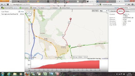
Hlab help me out here. When you say save in the 'metrics' section do you mean change the units on the top right of the screen from imperial to metric. If it is this I still cannot see the average gradient on the climb. I saved it separately as you suggested and can still get the different % at different points but no average. Where am I going wrong?
 
Hlab help me out here. When you say save in the 'metrics' section do you mean change the units on the top right of the screen from imperial to metric. If it is this I still cannot see the average gradient on the climb. I saved it separately as you suggested and can still get the different % at different points but no average. Where am I going wrong?

Once you save the route and view it there are three tabs/options on the right 'Overview', 'Metrics' and 'Photos' you just have to select the 'Metrics' (middle) one.

RWGPS.jpg
 
Top Bottom